In 1997, Morrisburg was amalgamated with the Village of Iroquois, Matilda and Williamsburg Townships into the Township of South Dundas, in the United Counties of Stormont, Dundas and Glengarry along the north shore of the St. Lawrence River. The county was named in 1792 to honor Henry Dundas, who was Lord Advocate for Scotland and Colonial Secretary at the time. Matilda and Williamsburgh were two of Upper Canada’s original eight Royal Townships.
On November 11, 1813, the Battle of Crysler’s Farm, at which a British force repelled an invading American army, took place near here. United Empire Loyalists settled in Dundas County creating West Williamsburg; it was part of the Williamsburg Canal project. Between 1843 and 1856, canals were built on the north side of the St. Lawrence River. West Williamsburg was renamed Morrisburg in 1851 in honor of Brockville politician, James Morris, who was the first Postmaster General of the United Provinces of Canada. By 1860, Morrisburg had a growing manufacturing base consisting of a gristmill, a carding mill and a fanning mill. The Grand Trunk Railroad reached Morrisburg in 1855. A hydroelectric power plant was built in 1901.
During the 1950s, portions of Morrisburg were relocated because of expected flooding which would occur with the St. Lawrence Seaway project. Over eighty homes were moved and the entire downtown business district was demolished and relocated in a shopping plaza. The Canadian National Railway line was moved about a kilometer north of its original location. Much of the former rail bed was used for reconstructing Highway 2. Buildings and other artifacts were moved and assembled to create Upper Canada Village, a tribute to the area’s pioneers.
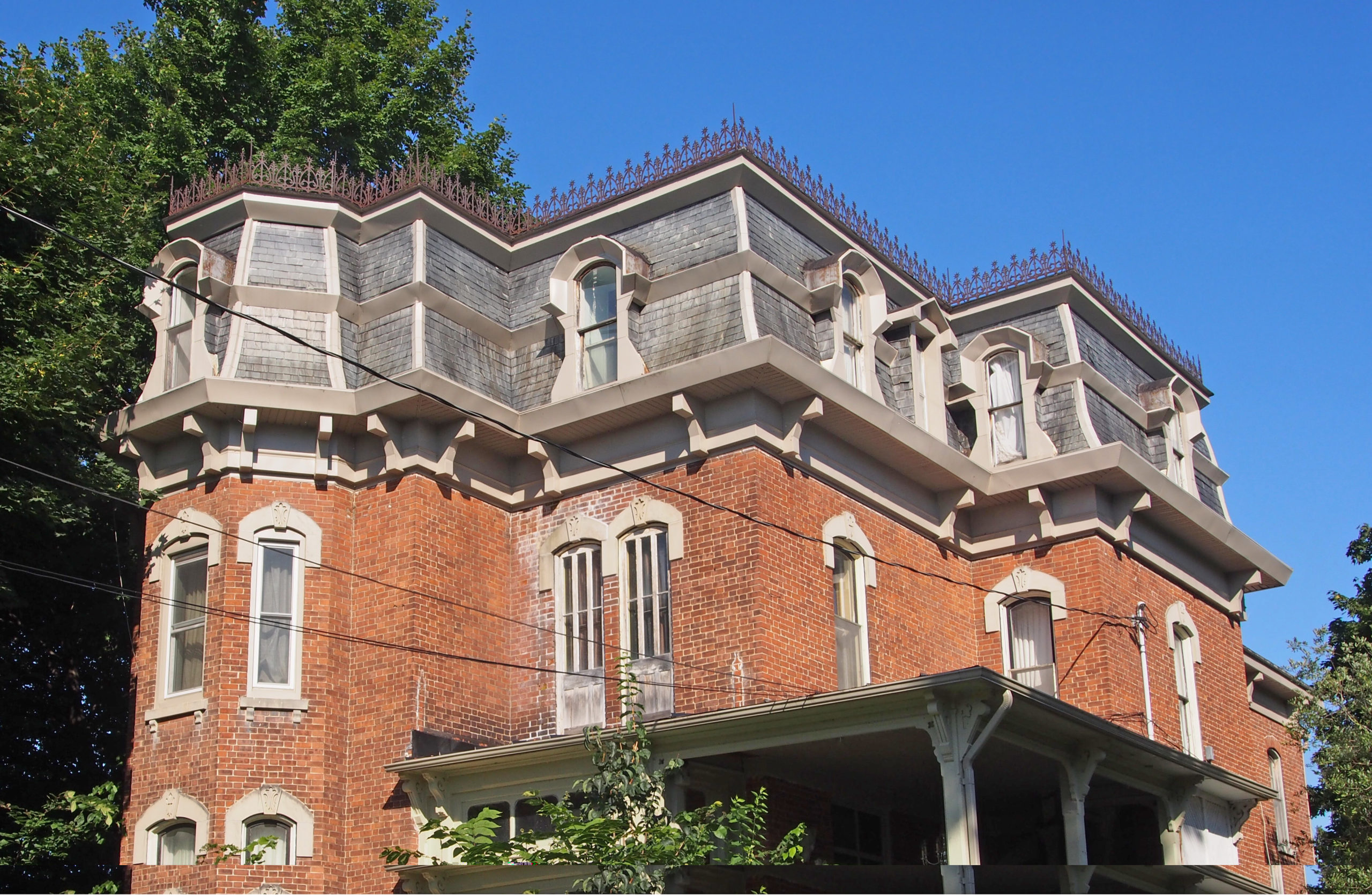
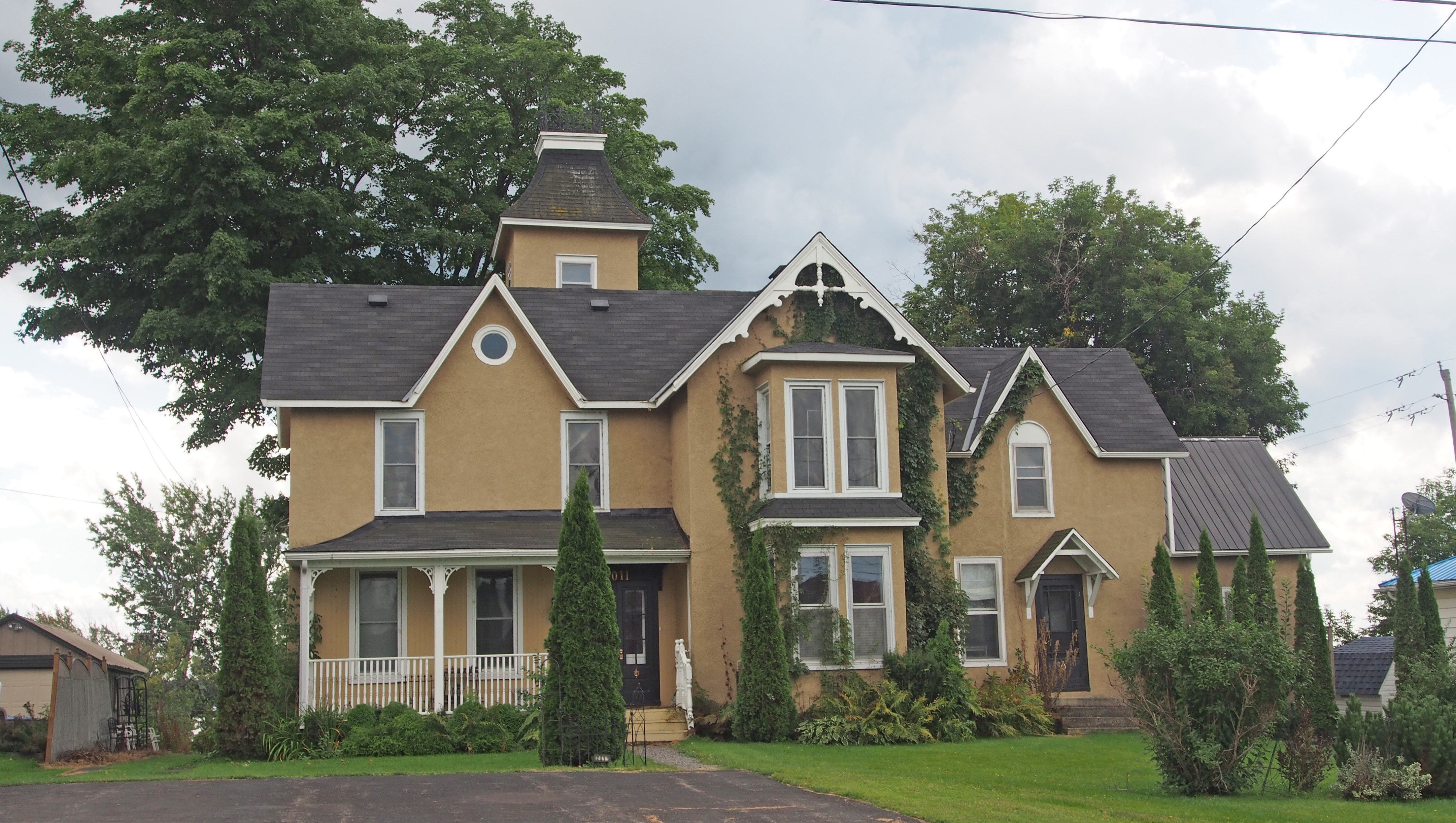
31 Lakeshore Drive – Second Empire style – projecting central tower, concave mansard roof, dormers; has eighteen stained glass windows, each with a different color scheme
19 St. Lawrence Street – Italianate Villa – built 1876 – wrought iron fence; corner tower with its tall, four-sided lantern contains four pairs of Italianate round headed windows; classic Italianate porch and front door
29 St. Lawrence Street – Second Empire – central tower directly above the front door topped with a belvedere; mansard roof with dormers
22 Lakeshore Drive – Second Empire – built 1879 – mansard roof, rounded dormers, heavy cornice brackets48 Lakeshore Drive – Italianate, paired cornice brackets, decorative porch and verandah supports; transom50 Lakeshore Drive – Victorian – two-story bay windows with iron cresting above, widow’s walk balcony on rooftop with iron cresting, dormers with finials; verandah with ornate capital detailing on the support posts with spindles under the corniceLakeshore Drive – Georgian style – hipped roof, balanced facade, bay windows36 First Street – Russell Manor Bed and Breakfast – Second Empire style, mansard roof, cornice brackets, patterned slate roof, bay window16 First Street – Gothic Revival – built 1870s – wide, bold barge boards, central pinnacle suspended beneath the peak ending in a knob-like pendant above the third floor window; intricate cut-out patterns adorning the gable ends24 High Street – Gothic Revival style – symmetrical organization, steeply pitched roof gables, tall twin window bays; dichromatic brickwork; transom windows52 High Street – Neo-colonial – gambrel roof
South Dundas is a municipality in eastern Ontario in the United Counties of Stormont, Dundas and Glengarry along the north shore of the St. Lawrence River. It is located about sixty miles/one hundred kilometers south of Ottawa. The township was created on January 1, 1998, by amalgamating the former townships of Matilda and Williamsburg with the villages of Iroquois and Morrisburg. (Morrisburg is big enough to be a separate book.) Mariatown is located in the township.
The McIntosh apple was discovered and cultivated in South Dundas near Williamsburg. John McIntosh moved to Upper Canada in 1796. In 1811 he acquired a farm in Dundela, and while clearing the land of second growth discovered several apple seedlings. He transplanted these, and one bore the superior fruit which became famous as the McIntosh Red apple. John’s son Allan established a nursery and promoted this new species extensively.
Morrisburg and Iroquois were partially flooded by the creation of the St. Lawrence Seaway in 1958. Unlike the Lost Villages of Cornwall and Osnabruck Townships, the two towns were relocated to higher ground in the same area.
An artificial lake, Lake Saint Lawrence, now extends from a hydroelectric dam at Cornwall to the control structure at Iroquois, and replaces the formerly narrow and turbulent section of river that was impassable to large vessels.
Cardinal
Edwardsburgh/Cardinal is a township in the United Counties of Leeds and Grenville of eastern Ontario. Edwardsburgh Township was surveyed in 1783. The Township of Edwardsburgh/Cardinal was formed on January 1, 2001, through the amalgamation of Edwardsburgh Township with the Village of Cardinal. It is a historical community with many old homes and buildings, including one-room school houses, grist mills, and churches. It is situated along the St. Lawrence River and extends back into rural hamlets. The South Nation River passes through the township. The township’s main population centers are Cardinal, Johnstown, and Spencerville.
Ten percent of the area’s water drains into the St. Lawrence, while ninety percent drains into the South Nation River. The flow of the South Nation River through this area is very sluggish with poor drainage, due to the fact there is little drop in elevation along the river; this leads to the formation of bogs and swamps, and also makes the area prone to seasonal flooding.
Up until the 18th century, the land was covered with thick, mature, mixed forests. The original forest was almost completely cleared throughout the years and the forest that stands today is mostly secondary growth over previously cleared land. The forests in the area presently contain numerous types of deciduous oak, birch, ash and maple trees. The common coniferous trees in the area include many types of pine and cedar as well as balsam fir and white spruce. In the darker, acidic soils around the bogs and swamps there are tamarack trees, as well as juniper and black spruce.
In 1673, the French, working with native tribes from the area, built a storehouse on Old Breeches River, now known as Johnstown Creek. This storehouse was used to hold supplies for upriver trading posts such as Fort Frontenac (now Kingston). In 1759, The French settlers built Fort de Levis on Chimney Island, in the St. Lawrence River just off of Johnstown, between it and Ogdensburg. The purpose of this fort was to protect the St. Lawrence River from the British. It was captured by Major-General Jeffrey Amherst in August 1760 during the Battle of the Thousand Islands. The island on which the fort once stood was permanently flooded during the construction of the St. Lawrence Seaway.
Johnstown
Before the construction of dams and later the Seaway, Johnstown was fronted by a calm section of the St. Lawrence River located between two rapids. By 1784, Loyalists were residing in the township and until 1790 the landing point and base camp for these settlers was at Johnstown.
Johnstown is part of the township of Edwardsburgh/Cardinal in the United Counties of Leeds and Grenville in eastern Ontario. It is located at the Canadian terminus of the Ogdensburg-Prescott International Bridge.
In 1792 John Graves Simcoe, the first Lieutenant Governor of Upper Canada, established himself in Johnstown which then became the district’s administrative seat. This led to the court of quarter sessions (the district’s government) alternating its meeting location between Johnstown and Cornwall, and to the construction of a courthouse and gaol. The courthouse was a log structure, which stood near the present site of the Prescott-Ogdensburg Bridge. By the late 1790s, the village was also home to a sawmill, gristmill, and an inn and tavern. Census records indicate by 1807, there were thirty-six houses and a general store. In 1808, the Seat of Justice was moved to Elizabethtown (now Brockville), as it was a more central location in the district.
New Wexford is located in Edwardsburgh/Cardinal Township, in the United Counties of Leeds and Grenville of eastern Ontario.
Prescott
Prescott is a small town located on the north shore of the Saint Lawrence River in the United Counties of Leeds and Grenville. Colonel Edward Jessup remained loyal to the British during the revolutionary war. He was granted 1,000 acres and in 1810 had building lots surveyed for the town which he named in honor of General Robert Prescott who had been Governor-in-Chief of Canada between 1797 and 1807.
Prescott was a strategic military site for the protection of the Canadian border against American and French invasions. Fort Wellington was built in 1812 to defend the St. Lawrence River and the town. Prescott is located at the head of the St. Lawrence rapids. Before the completion of the canals between here and Montreal in 1847, Prescott was the eastern terminus of Great Lakes navigation.
Established in 1810, it became a center for the forwarding, or shipping, trade and an important center in Montreal’s commercial system. One of the earliest forwarders at Prescott was Captain William Gilkison who began operations in 1811. The population of Upper Canada increased rapidly after 1820; the trade expanded and forwarding firms, including Henderson & Hooker, and Macpherson, Crane & Co., established ship building yards, wharves, and warehouses along the waterfront. The forwarding trade flourished before the building of railways and canals. The railway came in 1854.
During four days in November 1838, British troops and local militia defeated an invasion force of 300 American hunters and Canadian rebels. The Battle of the Windmill victory prevented the invasion force from capturing Fort Wellington in Prescott and cutting the St. Lawrence communications link, which would have left Upper Canada open to invasion.
By 1887, in addition to the fort, barracks, and military hospital, there were twenty-three hotels, twenty-four taverns, a distillery, two breweries, two foundries, two tanneries, two potters, a bank, a saw mill, a quarry, a brick factory, a shipyard, a grain elevator, and a farmers’ market building.
With a town of 3,000 people, smaller establishments and services were also present: a bowling alley, a theater, several newspapers, a telegraph office, bakeries, general merchants, doctors’ offices, a dentist, a library, a college, two schools, four churches, many docks and wharves with large storage buildings, and a ferry service to Ogdensburg, New York.
Maitland
Maitland is a small village in the United Counties of Leeds and Grenville. It is located along the St. Lawrence River about five kilometers east of the City of Brockville. Loyalists began to settle the area in the late 1700s and into the early 19th century by building homesteads, establishing businesses and opening small factories. During the early part of the century, Maitland was on the opposite end of a supply route running to Merrick’s Mills, which aided in its growth; the construction of the Welland Canal and other canal systems through the St. Lawrence allowed goods to be transported to and from the village. A wharf was used for collecting goods, and many mills were constructed.
One of Maitland’s most notable landmarks was constructed in 1828: the Longley Tower, which was originally built as a windmill along the St. Lawrence River. The tower had a brief life as a windmill, but it did not generate enough power to sustain anything for long; it was later converted into a distillery. Longley imported a steam engine from Europe, built a flour mill, and constructed a stone building out of which he ran a general store and post office. Major Charles Lemon constructed two mills, a foundry, and a blacksmith shop to serve the village.
Cardinal – Victorian – semi-circular spindle decoration on gable above two-storey rectangular bay windows; three-storey tower with iron cresting on top; decorative veranda support posts, open railing
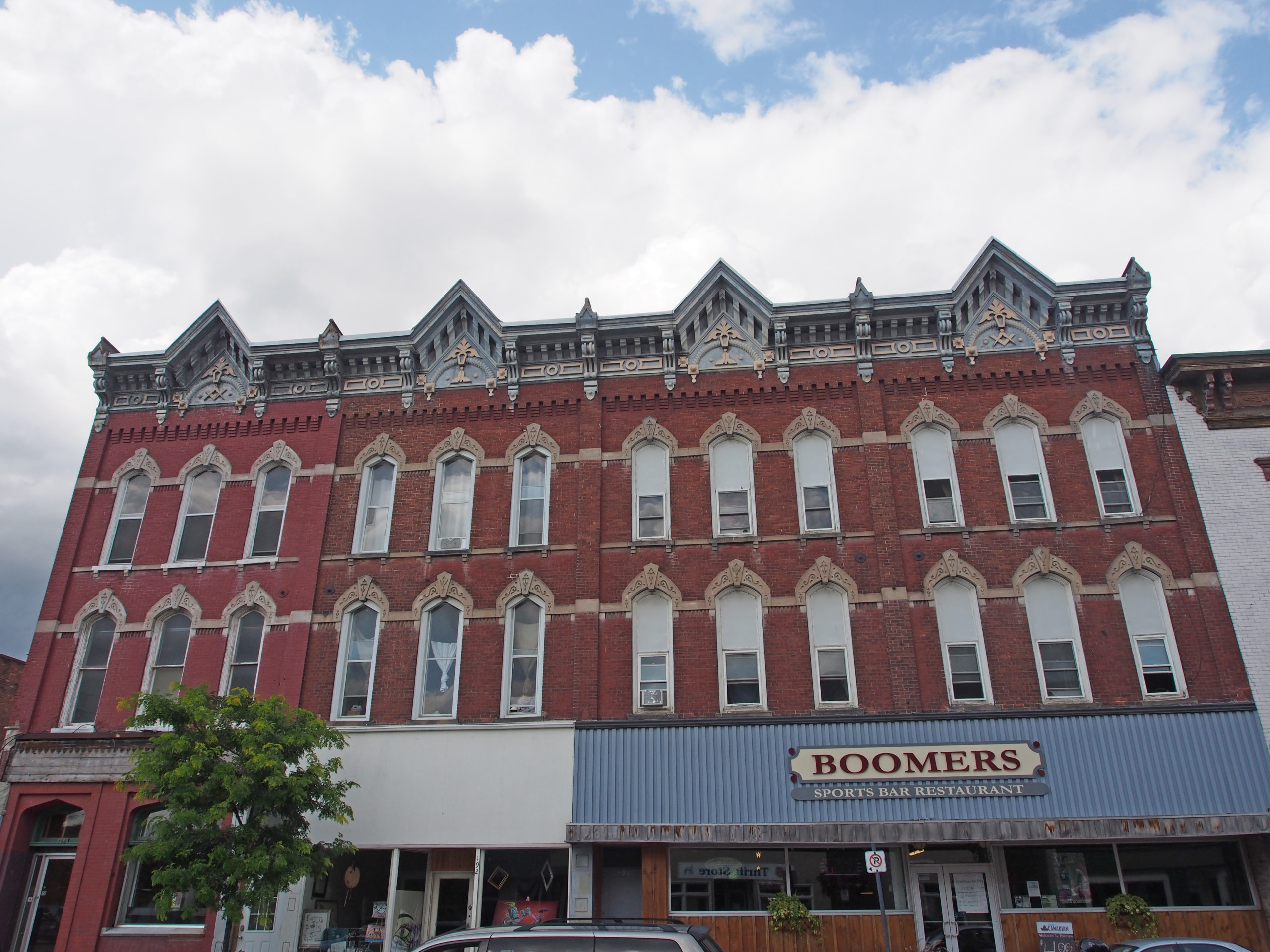
Mariatown – Gothic – gable roof, voussoirs with keystonesMariatown – 2½ stories, second floor balcony with open railing above rectangular bay window and open porchIroquois – Victorian – decorative veranda support posts, no railingCardinal – Gothic – stoneCardinal – 2062-2064 – Victorian style – voussoirs with keystonesPrescott – 186-198 King Street West – Masonic Block – 1879 – building is composed of four sections three stories high; arched windows with cornices and keystones decorated with linear designs; cornice brackets, beveled dentil molding; over the central bay of each section is a symbol of the Masonic OrderMaitland – Stone, dormer, sash windows – home of Dorothy Martha Dumbrille, novelist, poet, historian, author of ten books – During World War II she wrote a novel, All This Difference, which addressed the tensions between the French Canadian inhabitants and the early Scots living in Glengarry County. This house, her ancestral home, was the setting of a subsequent novel, Deep Doorways, published in 1947.
Cornwall is Ontario’s easternmost city, located on the Saint Lawrence River about one hundred kilometers southeast of Ottawa. It is named after the English Duchy of Cornwall.
In June 1784, disbanded Loyalist soldiers and their families settled at New Johnstown, the site of present day Cornwall. Native traders and French missionaries and explorers came here in the 17th and early 18th centuries. By 1805 Cornwall had a court house, a schoolhouse, two churches and many homes. The construction of the Cornwall Canal in 1834-42 accelerated its development. Mills and large factories were erected along the canal.
The Cornwall Canal, a series of locks which carried boats18.5 kilometers around the rapids, was used for over one hundred years. Power drawn from the canal attracted textile and paper mills. The textile industry played a major role in Cornwall’s economic and cultural development. This canal was one of eight canals that connected western Canada with the ocean by way of the Great Lakes and the St. Lawrence River. The Canal was an important shipping center until the completion of The St. Lawrence Seaway in 1959.
Eastern Ontario has always been a highway or corridor through which people moved, a corridor used by migration and conquest. Prior to European colonization, the Mohawks and Six Nations Iroquois settled and raided through the St. Lawrence valley. The French and British fought over the waterway and, after the American Revolution in 1812–14, it became a battleground between Americans and Canadians. Formally founded to be a new home for refugees, it remained a home for refugees and migrants for much of its history.
Slavery was ended in the colony of Upper Canada in stages, beginning in 1793 when importing slaves was banned, and culminating in 1819 when Upper Canada Attorney-General John Robinson declared all slaves in the colony to be freed, making Upper Canada the first place in the British Empire to unequivocally move towards abolition.
The aftermath of the American Revolution resulted in the formal division of Upper and Lower Canada (later Ontario and Quebec) to accommodate Loyalists fleeing persecution in the new United States, and distribution of land throughout Southern Ontario brought major change to Eastern Ontario.
The original 516 settlers arrived with minimal supplies and faced years of hard work and possible starvation. Upon their departure from military camps in Montreal, Pointe Claire, Saint Anne, and Lachine in the fall of 1784, Loyalists were given a tent, one month’s worth of food rations, clothes, and agricultural provisions by regiment commanders. They were promised one cow for every two families, an axe, and other necessary tools in the near future. For the next three years, bateaux (boat) crews delivered rations to the township, after which residents were left to fend for themselves.
Cornwall was unusually integrated for a town in Ontario. For hundreds of years, the local population has been characterized by a mix of economic migrants, refugees and opportunists. Mixing of different social classes and ethnic backgrounds was common even early in its history, due to the interdependence demanded by isolation and the lack of support or interference from authorities.
In the 1780s to1830s, a “Bee” was a social event that pooled local labor resources, and was often a festive occasion. These “Bees” drew on many different classes, backgrounds and ethnic and linguistic groups working together for survival. These were very common in Eastern Ontario generally, and especially so in the early villages of the St. Lawrence valley.
Cornwall was once home to a thriving cotton processing industry. Courtaulds Canada, Inc.’s rayon manufacturing mill operated until 1992. Domtar, a Quebec-based company, operated a paper mill in the city for nearly 100 years, ceasing operations in 2006. Cornwall’s industrial base has now shifted to a more diversified mix of manufacturing, automotive, high tech, food processing, distribution centers and call centers.
36 Fourth Street West – St. Columban’s Rectory – Second Empire domestic architecture with mansard roof and detailing; window hood, trim on gable, bay window, cornice brackets; open railing on porch and wraparound verandah
Â
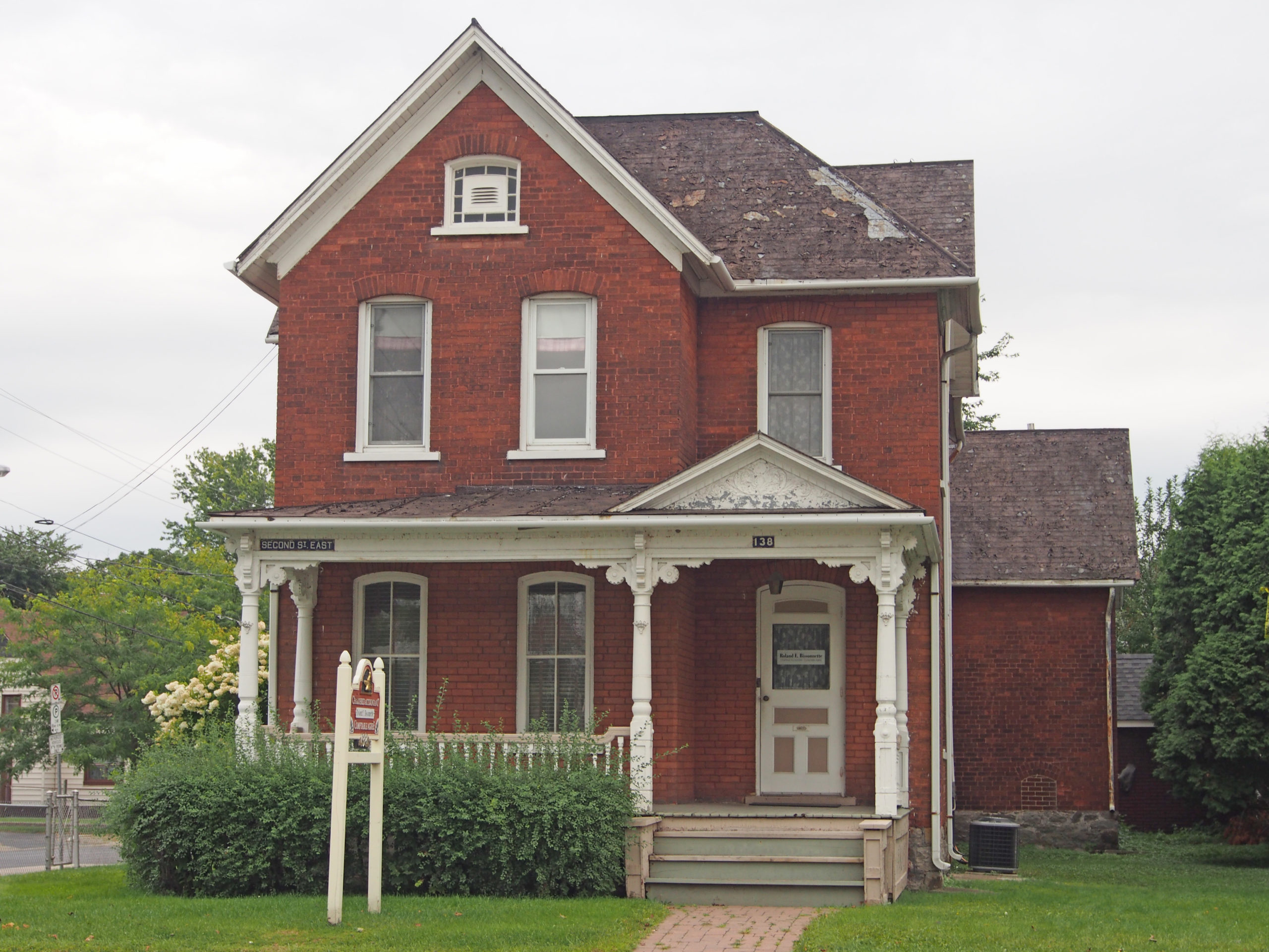
160 Water Street West – Wood House – 1840 – stone homestead – now Cornwall Community Museum220 Montreal Road – Bureau Office of the Diocese – arch over window with blind tympanum, open pediment above door300 Montreal Road – Italianate – hipped roof with dormer; pillars with Ionic capitals; pediment; quoining around windowsThird Street East – decorative gable on frontispiece, fish scale patterning, fretwork; second floor balcony237 Sydney Street – Gothic – rectangular bay window; enclosed porch with cornice brackets and pediment318 Augustus Street – Gothic Revival – wraparound verandah with cornice brackets, turned spindle supports, and open spindle railing101 Third Street West – Neo-colonial style – gambrel roof, dormer138 Second Street East – Gothic – decorative wood-turned veranda support posts, open railing, pediment with decorative tympanum
Kemptville is a community located in south eastern Ontario in the northernmost part of the United Counties of Leeds and Grenville and is about fifty-six kilometers south of Ottawa. Kemptville Creek begins southwest of the town, divides Kemptville, and flows four kilometers to empty into the Rideau River. Kemptville is composed of forests and farmland. The name Kemptville was adopted in 1829 as a tribute to Sir James Kempt, the Governor of British North America.
In 1812, Lyman Clothier bought one hundred acres of land from John Byce for the price of a yoke of oxen, and a flintlock rifle. Mr. Clothier had lived in the area since 1804 or 1805, and in 1812 he and his four sons built a saw mill, and two houses in what is now Kemptville. The mill was important for the settling of the community; in order to construct a crude dwelling, lumber was required. The mill provided lumber for settlers throughout Oxford Township.
The village was located on the Ottawa-Prescott Road and many travelers passed through the settlement. Â One of Mr. Clothier’s sons, Asa, opened his home to these travelers as a resting and meeting place. The “Clothier’s Hotel” was born. A grist mill was added in 1821 when the Clothiers placed some grinding stones in the lower part of their saw mill. Rather than taking their grain to a site on the St. Lawrence River, a daunting hike in the best of conditions, the settlers could now take it to this grist mill. A blacksmith’s shop was built and run by the Clothiers. A schoolhouse was built in 1823 and served the surrounding communities for many years. The first doctor arrived in the community in 1824. A weekly newspaper is published in Kemptville, called the Kemptville Advance, and has been published since 1855.
Elizabethtown-Kitley is a township in eastern Ontario in the United Counties of Leeds and Grenville. Its southern border lies along the St. Lawrence River and it extends north into many rural hamlets and villages. Also in the township are Addison, Forthton, and Newbliss.
Newbliss was settled mostly by Loyalists or immigrants from the British Isles who received their land here as grants from the Crown. One of the first businesses to operate here was Dack’s Tavern, built in 1817 and established as a tavern around the 1830s. The tavern had five rooms, three bed and horse stables, and also hosted Orange Lodge meetings. By the mid-1800s, the village began to flourish when roads improved in the area. By this time, the settlement consisted of two hotels, a blacksmith shop, a wagon shop, a general store, a post office, and its own schoolhouse. A cheese factory consisting of three buildings operated from Newbliss. The main building was later turned into the general store.
220-222 Prescott Street – de Pencier House – 1897- brick – Queen Anne style – tower, turret, iron cresting
216-218 Prescott Street – 1897 – Queen Anne style – towers, dormer
Â
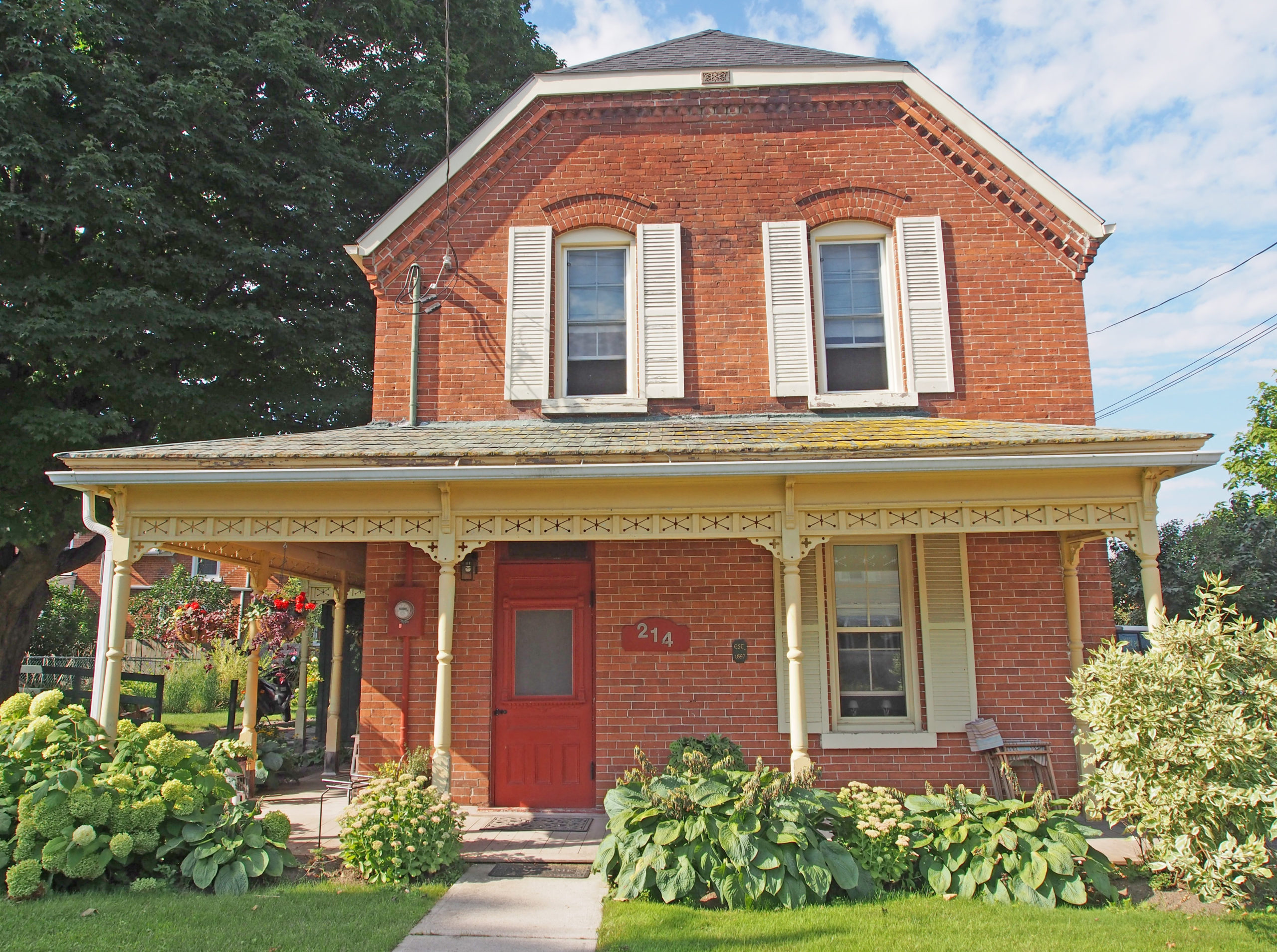
214 Prescott Street – 1897 – decorative brickwork under cornice; open wooden veranda with decorative railings and support postsOpen wooden verandas on both levels with decorative support posts and open railingsAddison – Italianate – hipped roof, cornice brackets, corner quoins, pedimentToledo – Gothic Revival – verge board trim on gables, painted corner quoins and voussoirs