Cobourg is a town in Southern Ontario ninety-five kilometers (59 miles) east
of Toronto and 62 kilometers (39 miles) east of Oshawa. It is located along
Highway 401. To the south, Cobourg borders Lake Ontario.
The settlements that make up today’s Cobourg
were founded by United Empire Loyalists in 1798. The Town was originally a
group of smaller villages such as Amherst and Hardscrabble, which were later
named Hamilton. In 1808 it became the district town for the Newcastle District.
It was renamed Cobourg in 1818, in recognition of the marriage of Princess
Charlotte Augusta of Wales to Prince Leopold of Saxe-Coburg-Saalfeld (who later
become King of Belgium).
By the 1830s Cobourg had become a regional
center, much due to its fine harbor on Lake Ontario. In 1835 the Upper Canada
Academy was established in Cobourg by Egerton Ryerson and the Wesleyan
Conference of Bishops. On July 1, 1837, Cobourg was officially incorporated as
a town. In 1841 the Upper Canada Academy’s name was changed to Victoria
College. In 1842 Victoria College was granted powers to confer degrees.
Cobourg retains its small-town atmosphere,
in part due to the downtown and surrounding residential area’s status as a
Heritage Conservation District. The downtown is a well-preserved example of a
traditional small-town main street. Victoria Hall, the town hall completed in
1860, is a National Historic Site of Canada. The oldest building in the town is
now open as the Sifton-Cook Heritage Centre and operated by the Cobourg Museum
Foundation.
Food processing is the largest
industry in Cobourg, and it is home to SABIC Innovative Plastics and Weetabix.
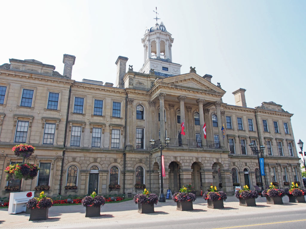
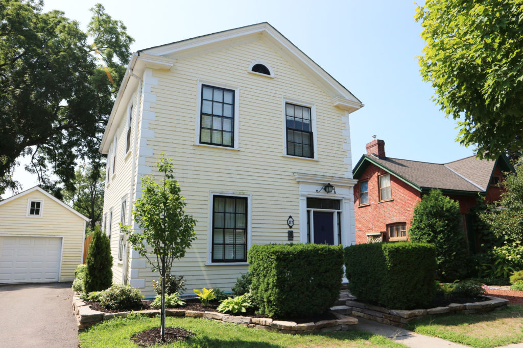
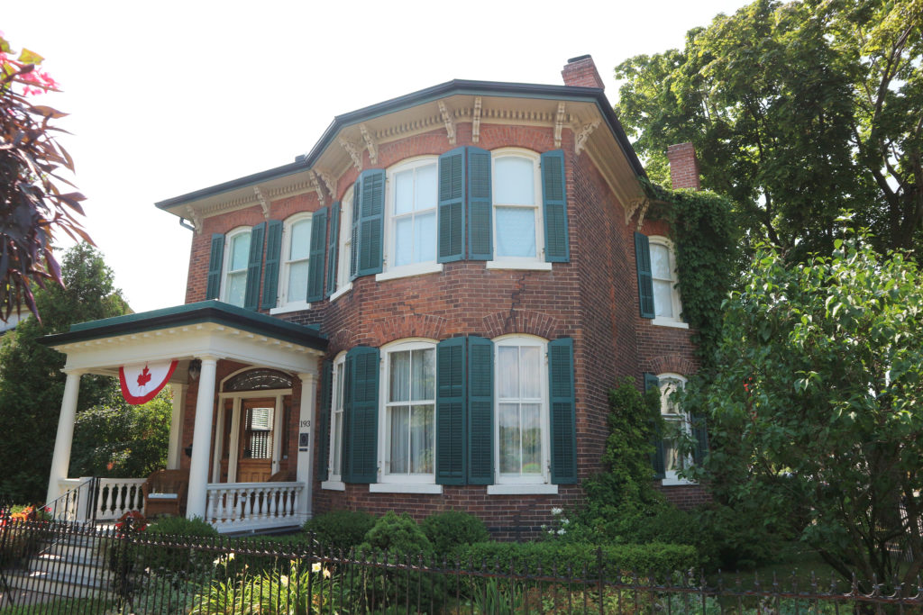
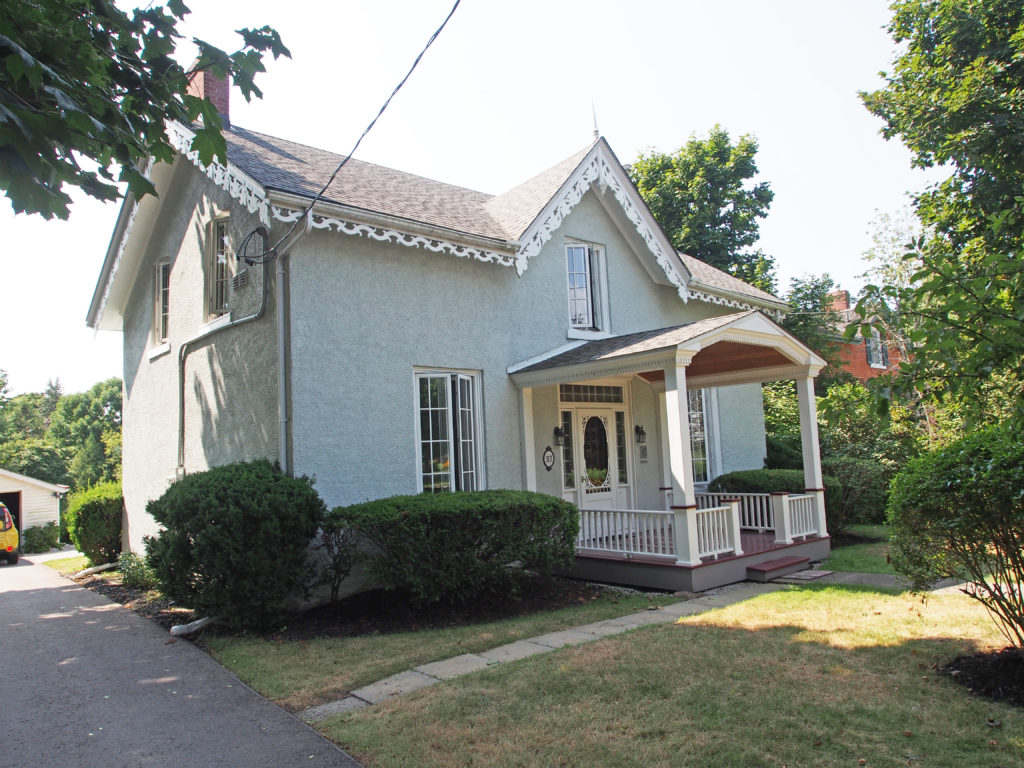
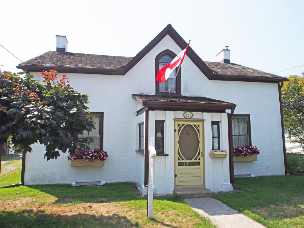
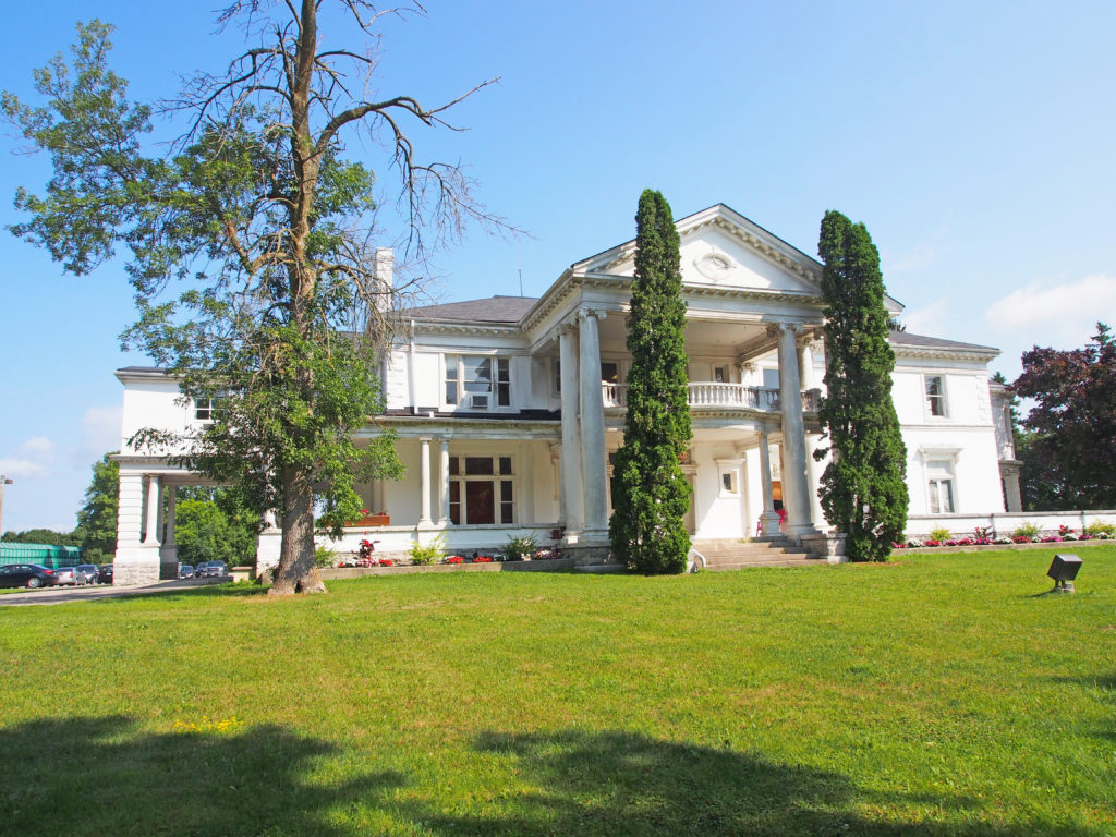
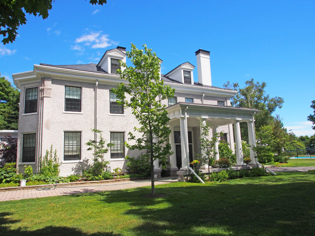
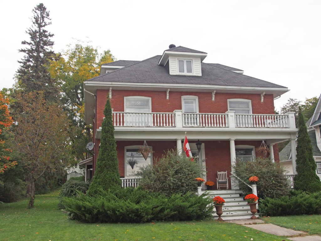
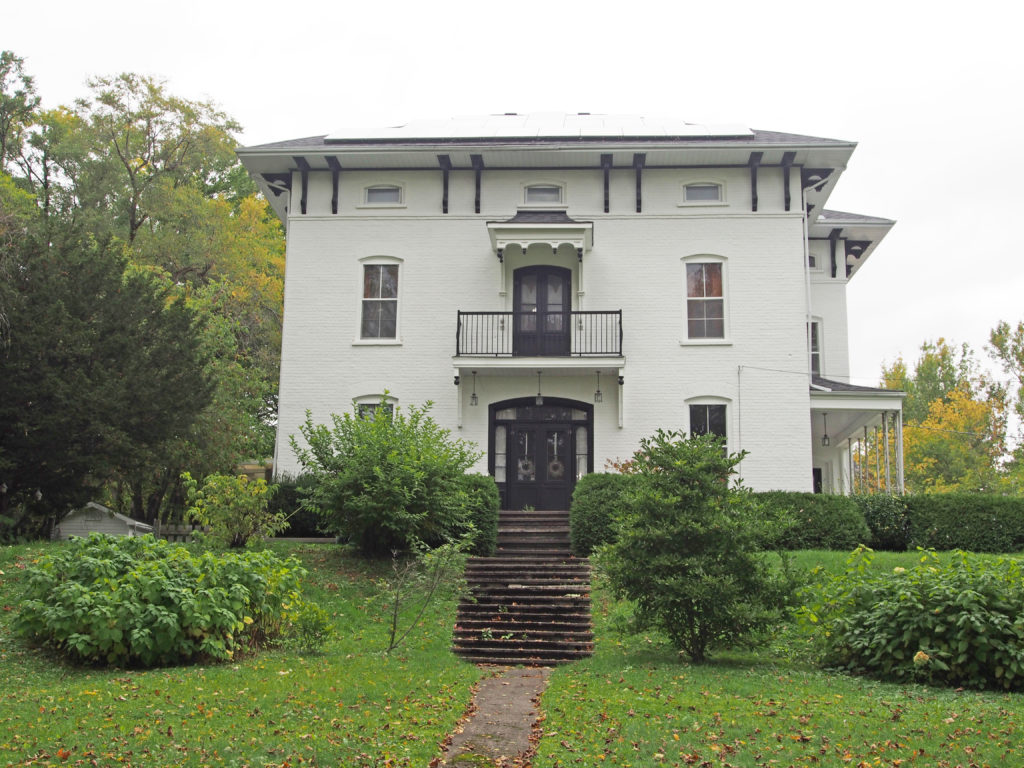
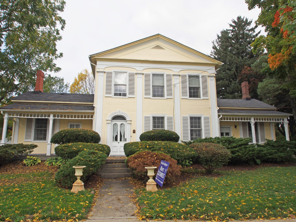
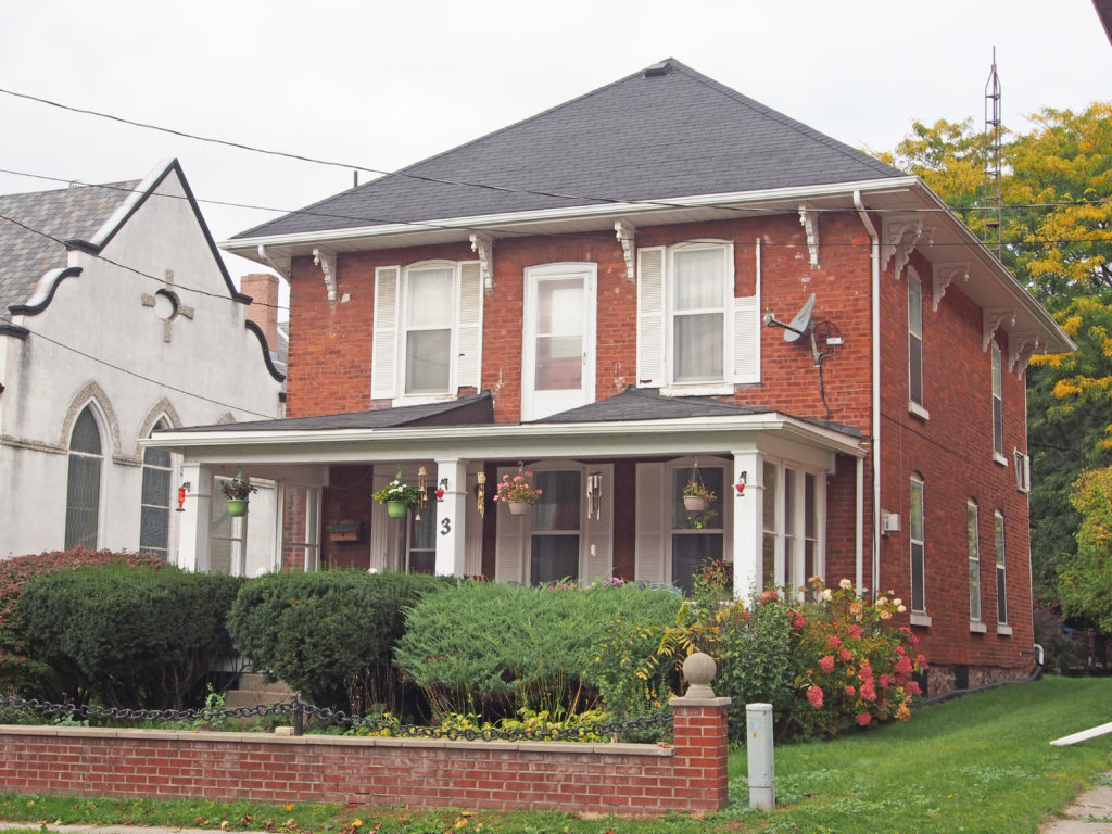
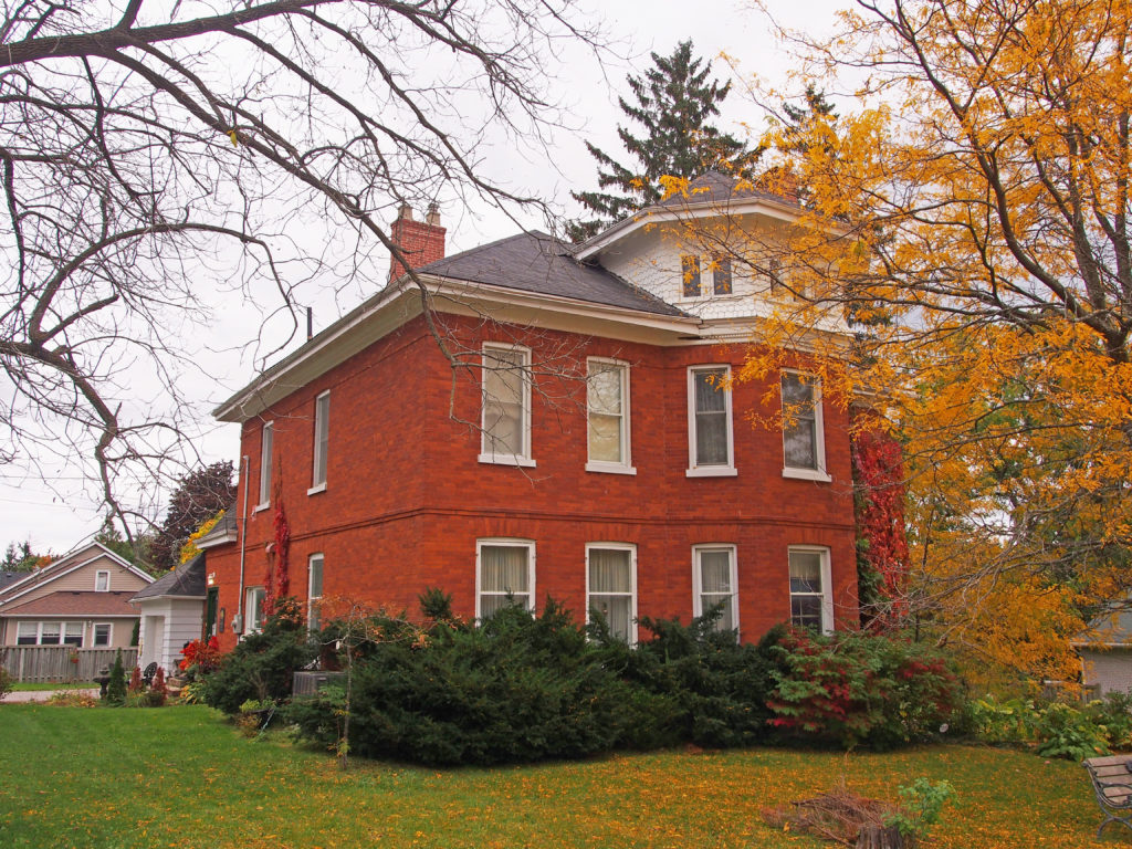
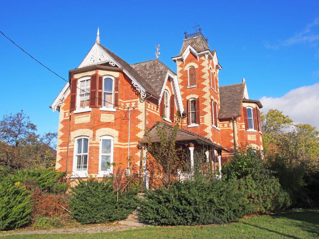
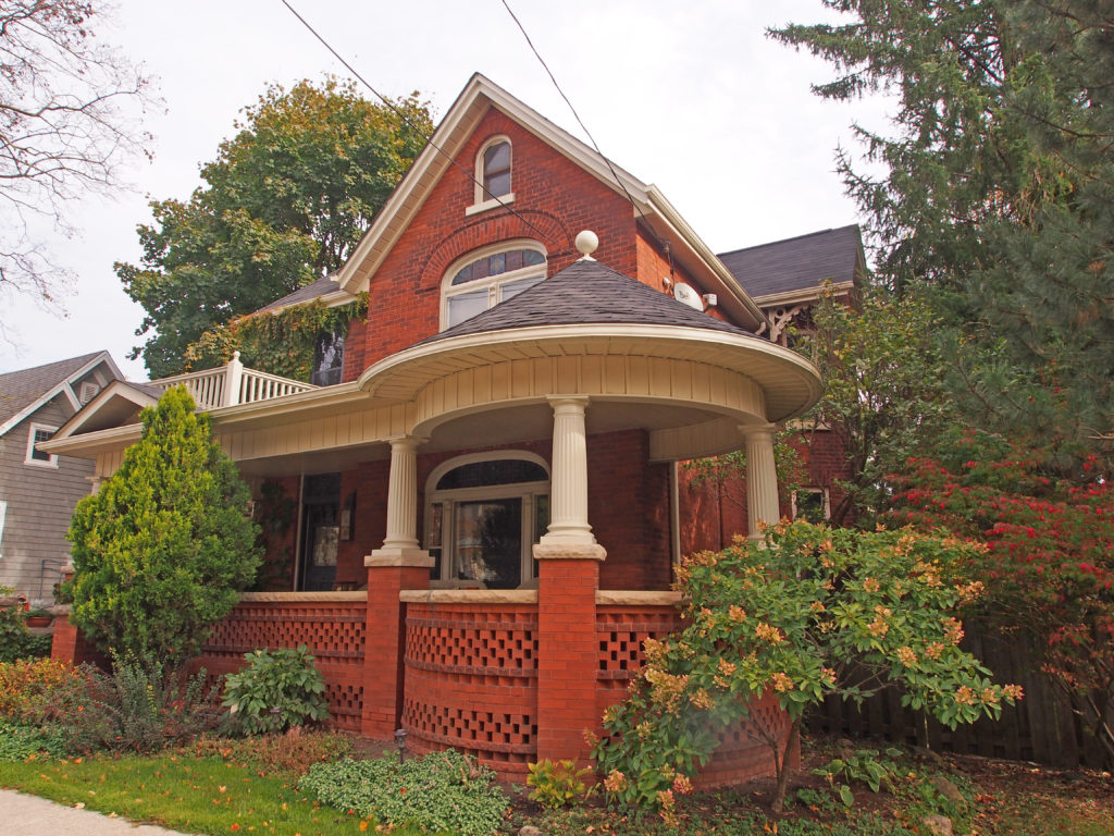
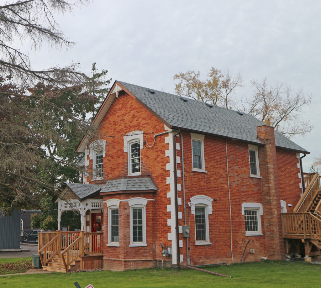
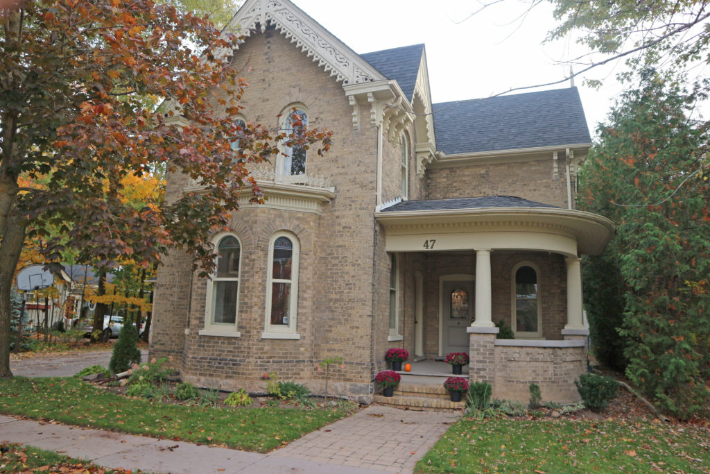
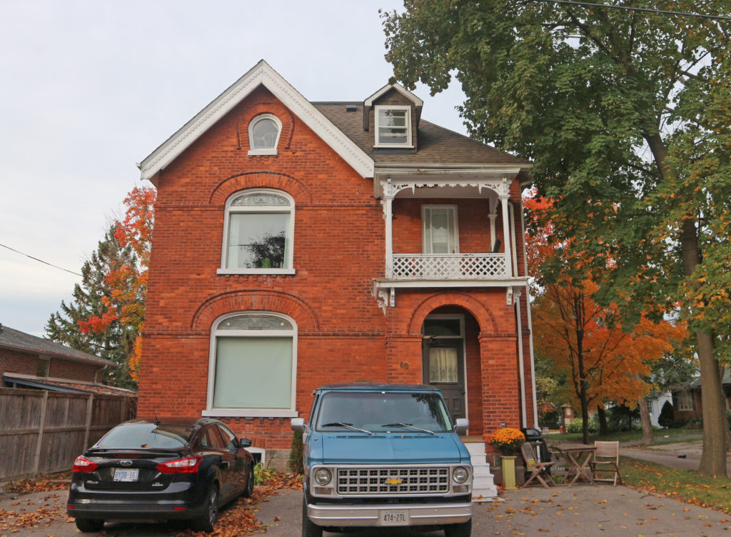
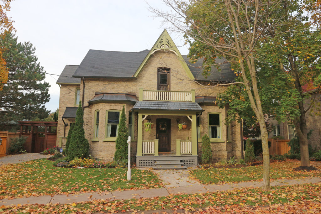
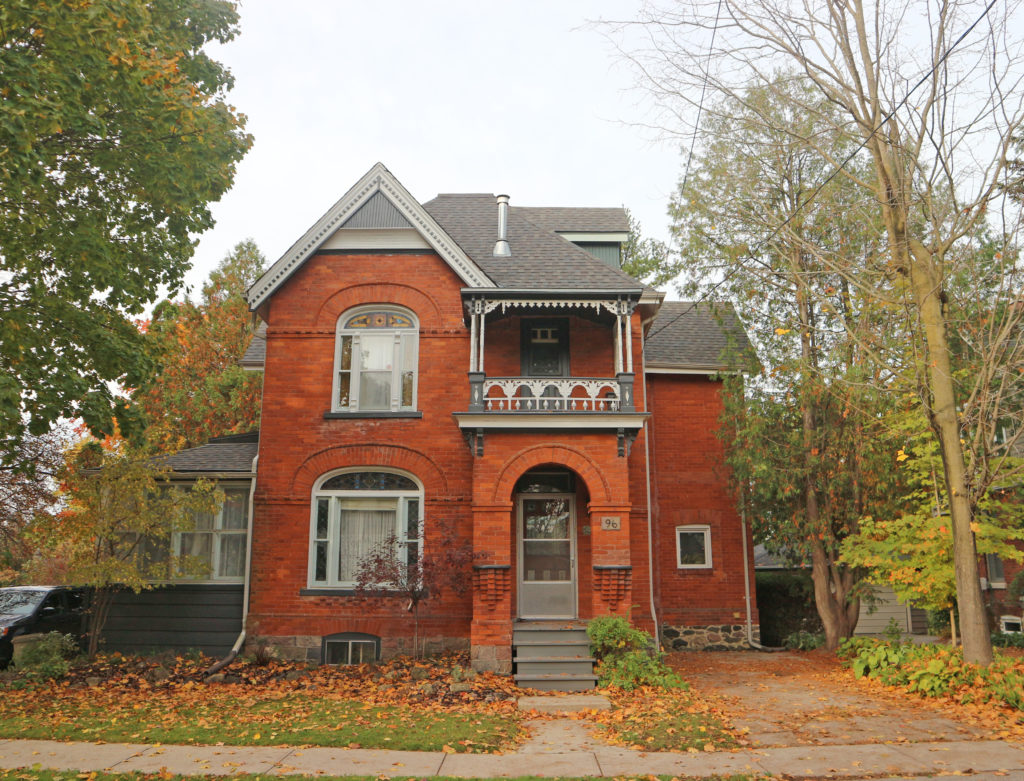
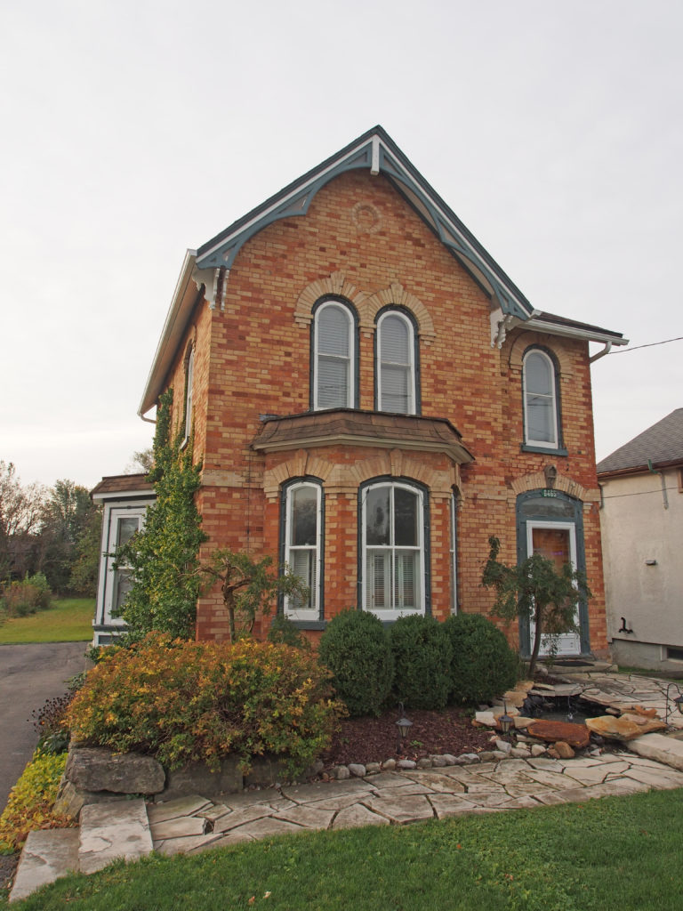
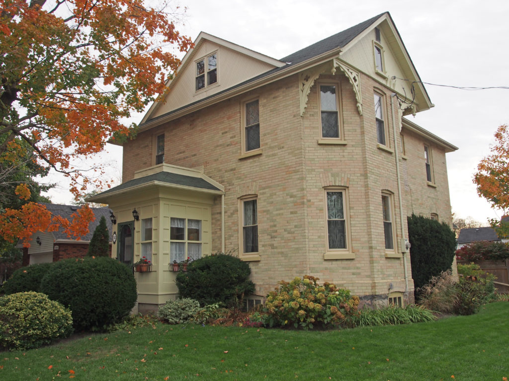
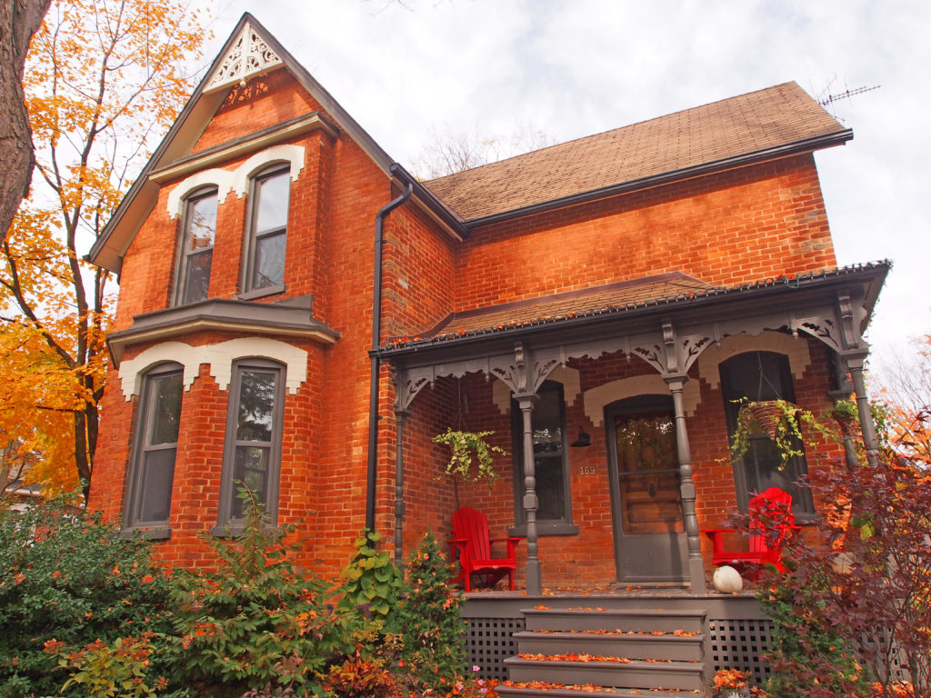
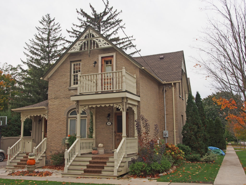
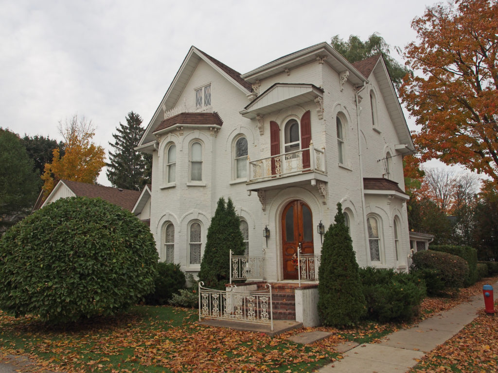
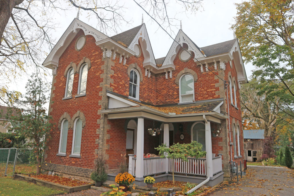
55 King Street West – Victoria Hall – 1860 – It is in the Palladian Neo-Classical architectural style with Corinthian capitals on the fluted columns and pilasters decorating the facade. The building is topped with a massive clock tower with Corinthian columns. On the first floor is a courtroom, and a concert hall on the second floor. Standing at the heart of the downtown is Victoria Hall, a building that now serves as the town hall, as well as home of the Art Gallery of Northumberland, the Cobourg Concert Hall, and an Old-Bailey-style courtroom that is now used as the Council chamber. Victoria Hall is a landmark known for its impressive stone work. Charles Thomas (1820-1867), an English-born master stone carver and building contractor, executed the fine stone carvings, including the bearded faced keystone over the main entrance into the building. Victoria Hall was officially opened in 1860 by the Prince of Wales, later to become King Edward VII of the United Kingdom.177 King Street West – c. 1848 – Greek revival style town house with exterior corner blocks of wood dressed to resemble stone, cornice return on gable, sidelights and transom, engaged columns193 King Street West – c. 1891 – cornice brackets, shutters295 King Street West – c. 1847-48 – This is a Vernacular Ontario Cottage and only cut stone house in Cobourg; it was built by Alexander Sutherland and was the home of the Delanty family for many years.317 King Street West – c. 1850 – 1½ story, center hall plan, wood house sheathed in stucco, verge board trim and finial327 King Street West – c. 1840s – 1½ story house with Gothic Revival elements – Birthplace and boyhood home of Father Francis P. Duffy, WWI Chaplain of the 69th New York Regiment, Rainbow Division, U.S. Army540 King Street East – Gothic – verge board trim, corner quoins, bay window, drip molds with keystones411 King Street East – Built in 1857 for Henry Mason, a director of Cobourg Railway. Architect was Kivas Tully. It is in the High Italianate architectural style with Corinthian capitals on the two story high columns, a second-floor porch with railing, dentil molding under the eaves, oriel window.390 King Street East – c. 1878 – Brookside Youth Centre – pediment with decorated tympanum above two-story veranda supported by Ionic pillars; dentil molding on cornice; lower level veranda has Doric pillars.214 King Street East – c. 1891 – Home of George Armour, son of Chief Justice of Canada (John Armour), from 1910 to 1930s. Queen Anne Style with irregular plan170 King Street East – c. 1840. This residence in the Georgian style was built by Joseph Townsend, and later owned by John Crease Boswell, Cobourg postmaster.160 King Street East – “New Hall”, 1913. English Cottage style of architecture. It was built by Senator Clive Pringle, whose wife was the daughter of Madame Albertini, proprietress of the Arlington Hotel.7 Fitzhugh Lane – Ravensworth, a waterfront mansion with four bedrooms and four bathrooms, built circa 1897 on Lake Ontario for a distinguished Union officer in the American Civil War. The Colonial Revival-style house sits on 3½ acres at the eastern edge of Cobourg. It is built to symmetrical Georgian proportions and embellished with Greek columns, an imposing portico and a large sun room with lake views. In the 19th century the town was known as resort for American steel magnates from Pittsburgh and other centers of the industrial United States. Among those barons traveling north to survey their iron mines near Marmora were members of Emma Shoenberger Fitzhugh’s family. She had married a military man thought to be the youngest general in the American Civil War. Many years after the war ended, Brigadier-General Charles L. Fitzhugh commissioned Ravensworth as a summer estate on 50 acres. Brigadier-General Fitzhugh looked to his roots in an old Virginia family and modeled the new summer getaway on an ancestral plantation house near Fairfax, Virginia.
The Township of Alnwick/Haldimand is located in central Ontario in
Northumberland County, situated between Lake Ontario and Rice Lake. It was
formed in 2001 by the merger of Alnwick Township in the north and Haldimand
Township in the south.
Alnwick Township was originally
surveyed in 1795 when twenty-four lots were laid out on the first concession.
It was named for Alnwick in Northumberland, England. The township’s first
residents were made up of United Empire Loyalists, attracted by large
unencumbered land grants, sometimes in the thousands of acres. In 1835, 3,600
acres of land along the first and second concessions were set aside as an
Indian settlement. Shortly after, the Indian Band from Grape Island was moved
into this settlement and a school and church were built at Alderville. The first
council meeting was held in 1845 at Alderville School. The Alnwick/Haldimand
Township building located in Grafton was built in 1858. Prior to its
construction, Township Council meetings were held at local taverns or the
residences of council members.
Haldimand Township was formed in
1791 and was named in honor of Sir Frederick Haldimand – a British general who
served as Governor-in-Chief of Canada between 1778 and 1796. By 1804, there
were 356 settlers in Haldimand Township making it the second most populous
township in the region after Hamilton Township to the West. The town hall was
constructed in 1860.
As part of provincial initiatives
in the late 1990s, the Government of Ontario pursued a policy of municipal
amalgamations to reduce waste and duplication. Alnwick Township and Haldimand
Township became a single Township of Alnwick/Haldimand on January 1, 2001.
Alnwick/Haldimand is part of the
Oak Ridges Moraine. Thirty-one square kilometers of the Cobourg Creek watershed
runs through the Township. The Creek supports a diverse ecosystem including
forests, meadows and wetlands. Numerous species inhabit the Creek including
brown trout, rainbow trout, scuplins and darters. Migratory Chinook Salmon
spawn in the creek and Atlantic Salmon are being stocked as part of a
provincial initiative to return these native fish to Lake Ontario. The
Ganaraska Forest is an 11,000-acre forest located in the Township. It is one of
the largest blocks of forested land in southern Ontario. The Millvalley Hills
Forest is a 297-hectare forest located within the Township. The dominant trees
species are red and white pine, and red and white oak. The township is rural
based with agriculture being the largest contributor to the economy. Grain,
cash crops, milk, livestock, vineyards and apple farming are all viable in the
area. Grafton is located in this township.
The first known settlers to Grafton were just before the turn of the 19th
century. These earliest settlers were all from the new United States of
America. Most were looking for new land and opportunities, a few were second
generation United Empire Loyalists born in loyalist settlements further east.
New settlers from the British Isles started arriving twenty years
later. These early Grafton settlers, as well as clearing agricultural land from
the forests, produced many fine political leaders. David Rogers was the first
to propose anti-slavery legislation for Upper Canada, and Henry Ruttan was the
Speaker of the Legislature. Likely the hamlet was named Grafton after John
Grover’s birth town of Grafton, Massachusetts. He initially arrived in Upper
Canada in 1798 and was in Grafton by 1804.
Bolton is a community in the town of Caledon, located in the Region of Peel about fifty kilometers northwest of Toronto. The downtown and area that historically defined the village is in a valley, through which the Humber River flows. The town was founded around 1822 when James Bolton helped build a flour mill for his relative George Bolton. It was established on the line of the Toronto, Grey and Bruce Railway with stages to and from Weston.
In the
Humber River valley, George Bolton, newly arrived from England, and his uncle,
James, an area pioneer from just after the completion of the 1819 survey, built
a grist mill at a bend in the river on land George had purchased from the
surveyor, William Chewett. This mill became the catalyst for several other
enterprises which became the seed of a hamlet. The village was strongly Reform
during the Mackenzie years and James Bolton had to seek refuge in the U.S.A.
after the failed rebellion of 1837. In 1842, his son James C. Bolton purchased
the mill site from his uncle and built a large flour mill at the site of the
current Humberlea Road, as well as a sawmill. The flour mill, in place until
1968, prospered under several prominent mill owners following Bolton including
John Guardhouse and Andrew McFall, both of whose homes still survive along King
Street East. The village continued to expand driven by water-powered industries
such as William Dick’s Agricultural Works.
While most evidence of the original mills and
other industries have disappeared, the nineteenth century residential fabric
remain largely intact and enough survives of the late nineteenth commercial
core to maintain the sense of the historic village. As it now stands, the area
is characterized by the polychromatic brickwork of the second half of the 19th
century in local brick with many of the finer homes incorporating a gabled ‘L’
plan with a veranda at the inside corner.
Sandhill
Ontario is about 9 miles east of Caledon.
Abraham Campbell’s father and six brothers took up one thousand acres in
Chingacousy about 1820, after having journeyed from the old family home in
Lincoln County by an ox-team. From Cooksville to their locations, the way led
over a road made through the bush with their own axes. Mr. Campbell spent his
life on the farm on which he was born when Chingacousy was the farthest
settlement north of the lake. A quarter of a century later Campbell’s Cross, on
the highway connecting north and south, was a scene of bustling life. There was
a tavern there with eighteen rooms. There were three stores in the village at
that time. As many as one hundred teams from the North Country would arrive
with grain in a single day. Part of the grain was bought by local merchants and
teamed by them to Port Credit for shipment by water. Some of the farmers hauled
their own grain all the way to the lake port.
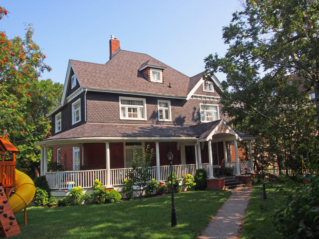
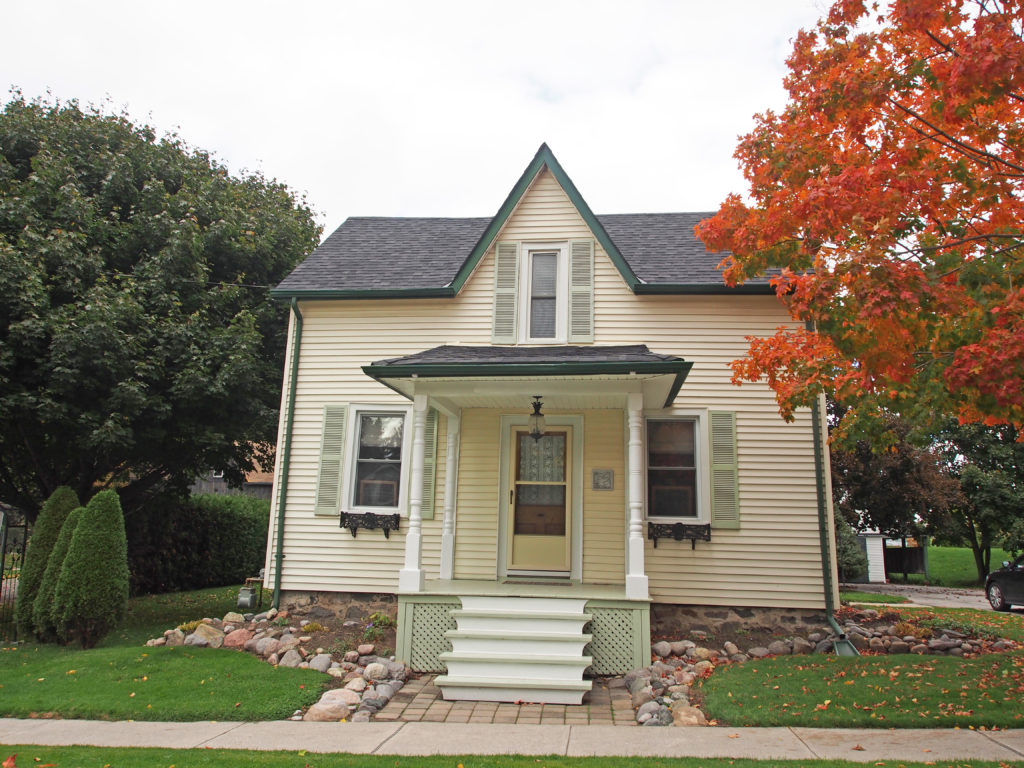
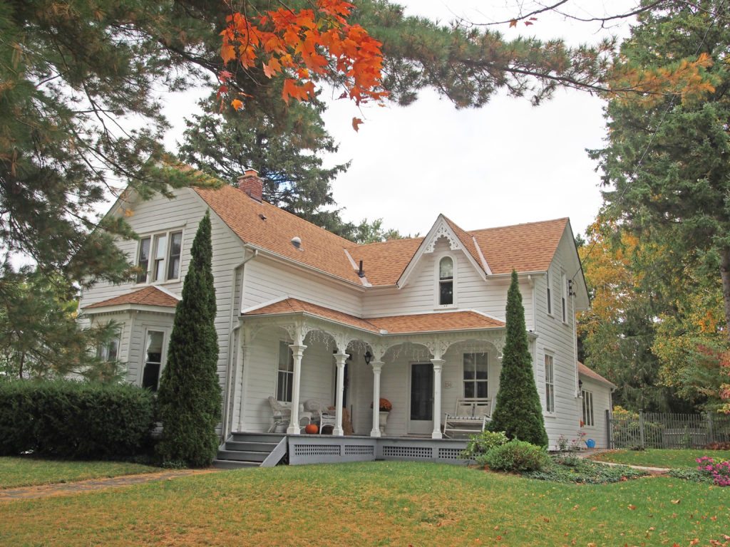
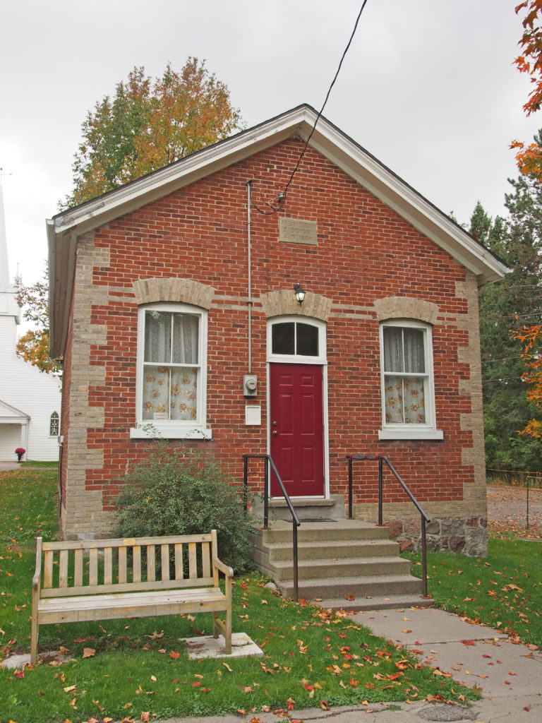
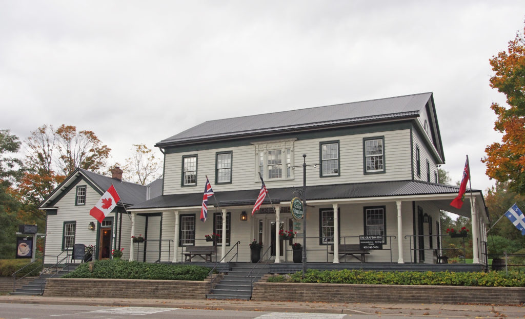
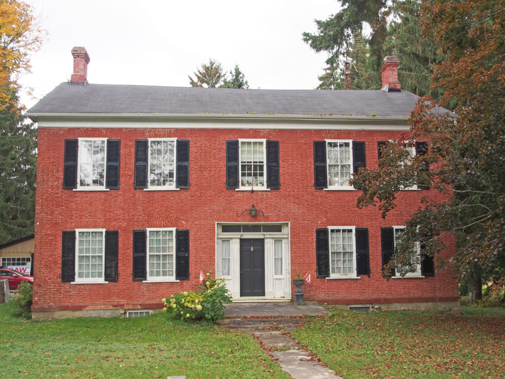
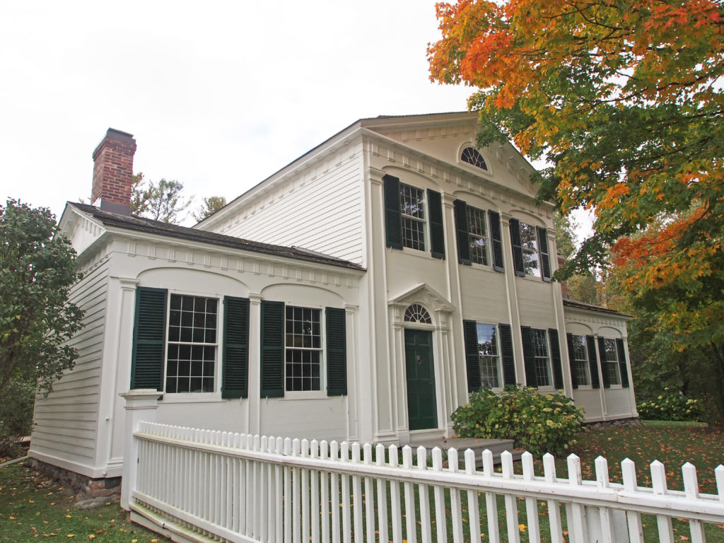
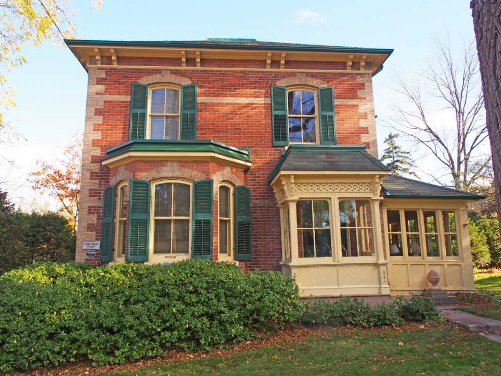
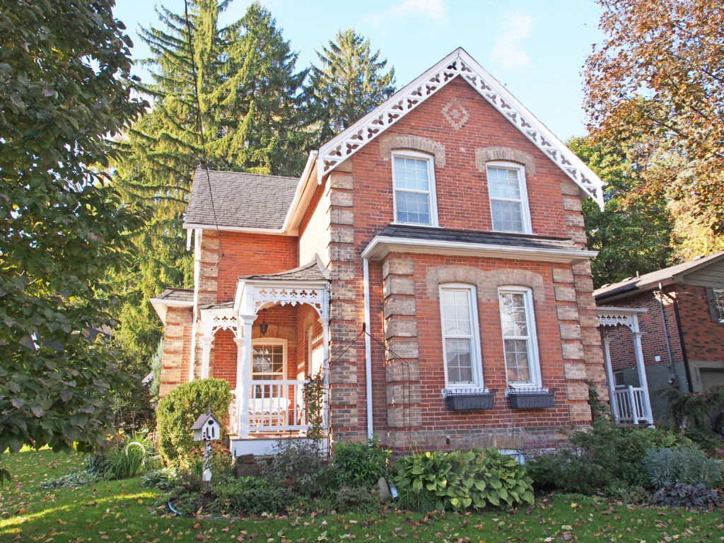
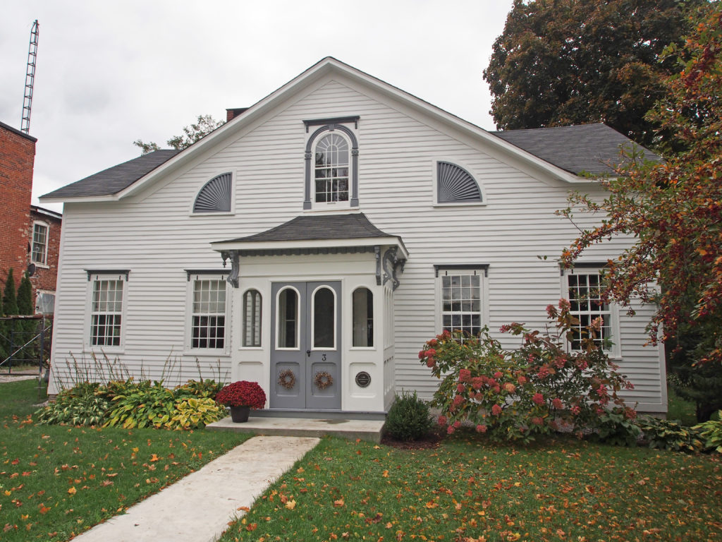
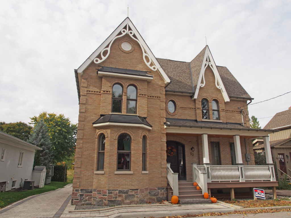
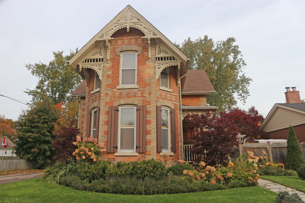
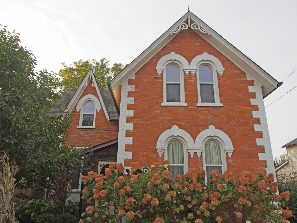
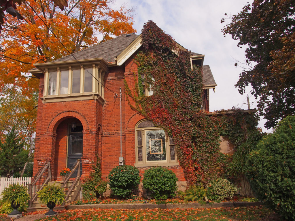
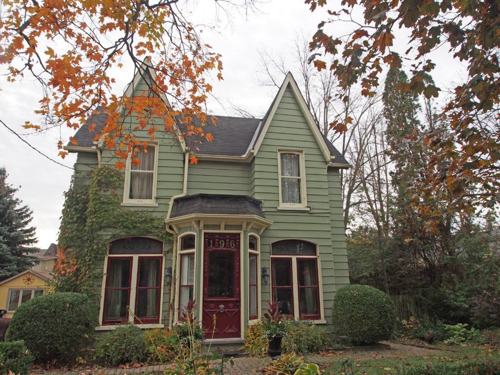
160 Old Danforth Road, Grafton – Old Foundry House – This house was originally a cabin built around the same time as the barn and was probably for the foundry manager. For a few years it was the rectory for St. Mary’s Church before the current rectory, on the hill above the church, was built.154 Old Danforth Road, Grafton – The Reuben Lawless House was built in 1870 and is mid-Victorian of the Italianate Vernacular, with “gingerbreadâ€. It has a stone/ rubble foundation and cedar siding and is of a balloon structure. The back “extension†was a woodshed/ summer kitchen built over the original well. In 1897 Thomas Lawless became the property owner and in 1900 Reuben Lawless Senior gained title. For years it was known as the Reuben Lawless House and stayed in the Lawless family until 1970.135 Old Danforth Road, Grafton – Old Presbyterian Sunday School was built in 1884. For many years it served as the Grafton Library. Architecturally it is notable for its patterned dichromatic brick work. There is a strong transom band, quoins and a foundation band topping a squared stone foundation, typically the work of Scottish masons.10830 County Road 2, Grafton – Grafton Village Inn was built in 1833 to replace a log building. The Neo-Classical building was restored in the early 1990s bringing it back to the early appearance that greeted travelers approaching from Kingston, York or Grafton Harbor. Its distinctive features include the front door surround with carved oak leaves and acorns, the second-floor Venetian window and the demi-lune windows at each gable end. The western wing was a later addition and at one time housed the telephone exchange.10715 Highway #2, Grafton – John and Mary Steele (nee Spalding) House is a handsome Georgian structure built by Thomas Spalding for his daughter Mary and her husband John Steele of Colborne. They moved here in 1843. The front door surround has several Neo-Classical features. Sections of the original brick are laid in Flemish bond. Over the years, deteriorating brick has been plastered over, painted and then stenciled to resemble brick.10568 County Road 2, Grafton – Barnum House (National Heritage Site of Canada) – The Barnum House was built between 1817 and 1819 by Eliakim Barnum, a United Empire Loyalist originally from Vermont. The house which stands just outside Grafton is the earliest example of Neo-Classical architecture in Canada. Barnum House was the first house museum to open in Ontario, restored and operated by the Architectural Conservancy of Ontario in 1940. In designing his house, Eliakim Barnum was influenced by American Architecture, popular in New England states at the beginning of the nineteenth century. This Neo-Classical style was intended to reproduce elements of classical Greek architecture. These include a central temple front with flanking wings, articulation of the facade with pilaster linked by elliptical arches, and extensive use of delicately scaled details. The Neo-Classical elements of the house’s exterior are echoed in the ornate woodwork of several interior rooms.25 Nancy Street, Bolton – Alice Goodfellow House – circa 1884 – This 1½ story Victorian Gothic home was built by George Watson for Alice Goodfellow using local red and yellow brick. The end gable patterning and the enclosed front porch are excellent examples of late nineteenth century urban architecture. Alice’s sister Margaret Smith lived next door. On Alice’s death in 1901, her brother-in-law Albion farmer James Goodfellow and his wife Marion retired here. It was in their family until the owner of 31 Nancy Street purchased it in 1999.31 Nancy Street – George Smith House – circa 1877 – This Italianate style home was built by George Watson for Margaret and George Smith. The red and yellow bricks were locally made and its exterior architectural features and beautiful enclosed porches are original. Smith, a sign painter and letterer, sat on the first village Council and was noted for his very realistic interior faux-wood graining. Erie Smith Schaefer inherited the house in 1933, living here with her husband Alex of ‘Smith & Schaefer’ Hardware. This dichromatic brick house is in the Italianate style. The orientation of the ‘L’ plan with the enclosed verandah along the south is distinctive. The bracketed eaves, segmentally arched windows and low medium pitch hipped roof are all typical of the Italianate.34 Temperance Street – Shore-Nease House – circa 1872 – This Victorian Gothic house was built by Henry Shore using red and yellow brick in a style typical of an urban village setting. The trillium patterned fretwork on the decorated wooden porch has been repeated on adjacent buildings. From 1892-1969, it served as office and surgery to Bolton doctors, including Dr. Lepper, Dr. A. Jackson, Dr. Graham and Dr. Taylor. The building is a fine example of a polychromatic brick ‘L’ plan residence featuring a diamond pattern at the gable of each section with accents of quoins and arches, and an ‘L’ form verandah formed at the inside corner between the two sections.12 King Street West – ‘The Castle’ – mid-1870s – A rare example of the Second Empire style with its mansard roof and square projecting bay, this house was built for Ann Roberts. Ownership passed to her son William L. Roberts in 1893 and from him to Margaret Jane Osburn in 1907. Olga and Wesley Strong and their son Charlie lived here until 1923 when Wes’s health failed. Charlie lived to 100 and was a great Bolton story teller. Mrs. Dickson owned the house in the 1930s and left it to her daughter Pearl who raised eight children here with her husband Lee Morrison.74 King Street East – Cabinet Maker’s House – circa 1846 – William Hughes, age 22, built this two-story, Neo-Classical style house. The saw mill down the street supplied the materials. It remains the earliest frame house standing in Bolton. Hughes, who specialized in cabinetry and chair making, lived in it with wife Jane and family until 1884. It then housed mill workers until Sarah Lundy and Harry Sheardown bought it in 1891, living in it for 43 years. Harry first worked in Dick’s Foundry, later owned a barber shop on Queen Street North and was considered one of Canada’s best all-round athletes.
Cramahe Township was established in 1792. Joseph Abbott
Keeler, son of the first settler of Cramahe Township, founded the village of
Colborne in 1815 when he opened the first store and post office. He had the
village surveyed, laid out the public square and donated the land.
Joseph Keeler (1770-1839) was the first
settler who landed on the shores of Cramahe Township with forty United Empire
Loyalist families from Rutland, Vermont. Keeler, his son Joseph Abbott Keeler
(1788-1855) and his grandson Joseph Keeler (1824-1881) were instrumental in
establishing the settlements at Lakeport, Colborne and Castleton.
A store established in Colborne in about
1819 by Joseph Keeler provided the nucleus around which a small community began
to develop. Within ten years, a distillery and a blacksmith’s shop had been
erected. Colborne was named after Lieutenant Governor Sir John Colborne. With
the establishment of a harbor nearby for the shipment of lumber and grain,
Colborne prospered. By 1846, it contained a foundry, a pottery, six stores,
three churches, tradesmen and artisans, and about four hundred residents. The
arrival of the Grand Trunk Railway in 1856, spurred further growth.
In 2001, Colborne and Cramahe Township were
amalgamated as part of municipal restructuring to form an expanded Township of
Cramahe.
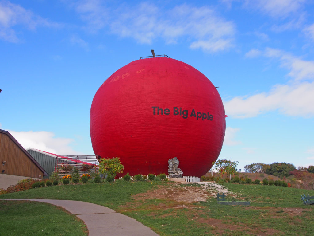
Colborne is the home of the Big Apple, a
tourist attraction located along Highway 401. The Big Apple is 10.7 meters (35
feet) tall and has a diameter of 11.6 meters (38 feet) – the largest apple in
the world. There is an observation deck on top of the apple, and adjacent to it
is a restaurant and a store to buy all your apple treats.
King
City is the largest community in King Township in York Region north of Toronto.
In 1836, a settlement styled Springhill was established in King.
With the arrival of the Ontario, Simcoe and Huron Railway in 1853, the settlement
began to expand. In 1890, the reeve of King Township James Whiting Crossley
incorporated King City by merging the hamlets of Springhill, Kinghorn, Laskay,
and Eversley. King City is characterized by rolling hills and clustered
temperate forests. Many lakes and ponds dot the area. Creeks and streams from
King City, the surrounding area, and as far west as Bolton and as far east as
Stouffville are the origin for the East Humber River.
The
King Township Museum in King
City is a local history museum for the township of King at 2920 King Road. The
museum consists
of a building which houses the majority of collections held. This building was
originally built in 1861 as the site of the Kinghorn School SS #23. It was
updated and expanded in 1958 and again in 1963, and purchased by the township
in 1978. The King Township Historical Society established the museum in 1979
and opened it in 1982.
The village of Nobleton is located in southwestern King Township and is surrounded by hills and forests. It was named after Joseph Noble and began as a settlement in about 1812. Most of the early settlers came from England, Scotland and Ireland. There are many horse farms here. The Humber River flows through the town. Nobleton was first settled in 1812, primarily based on its location midway between King City and Bolton on the east–west route, and Kleinburg and Schomberg on the north–south route. Taverns and hotels were built to serve travelers, and general stores and a post office were built to serve the fledgling businesses.
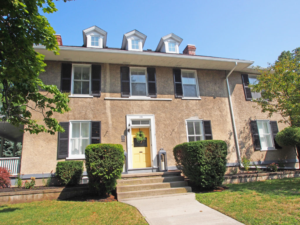
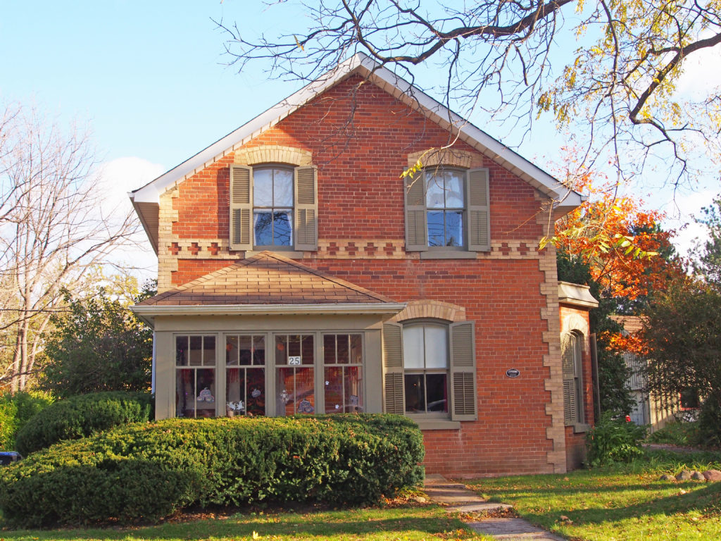
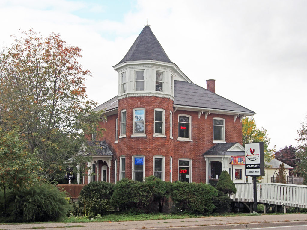
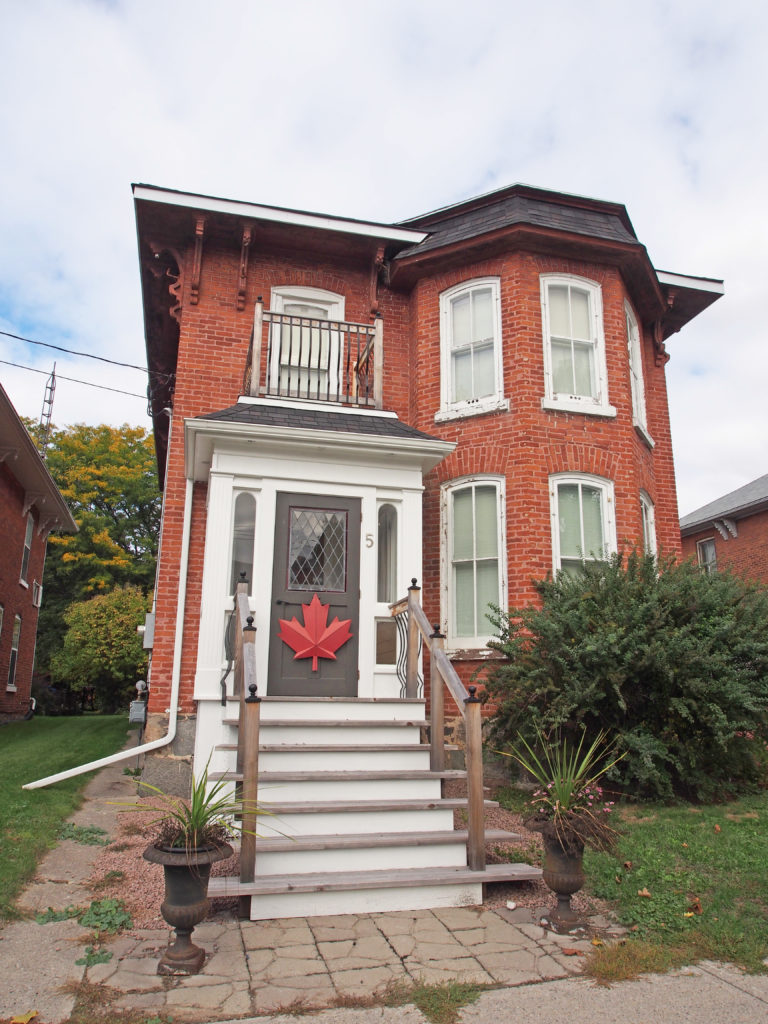
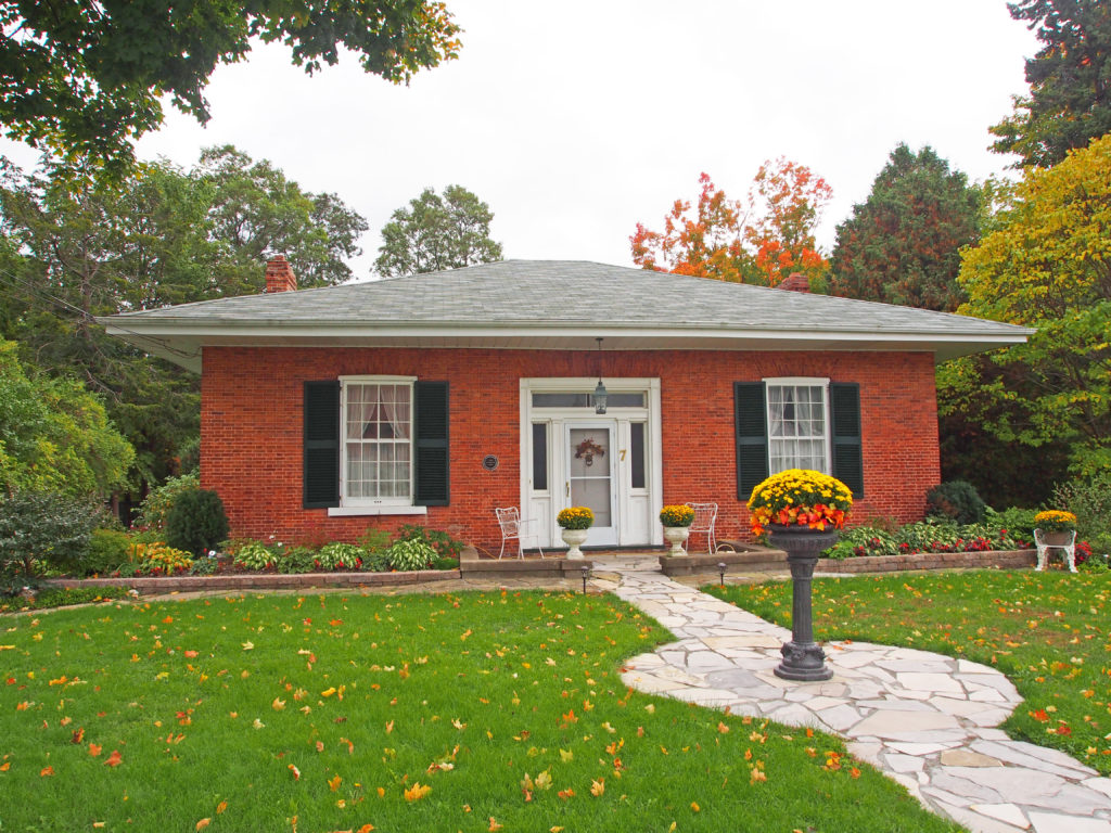
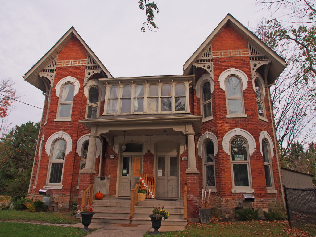
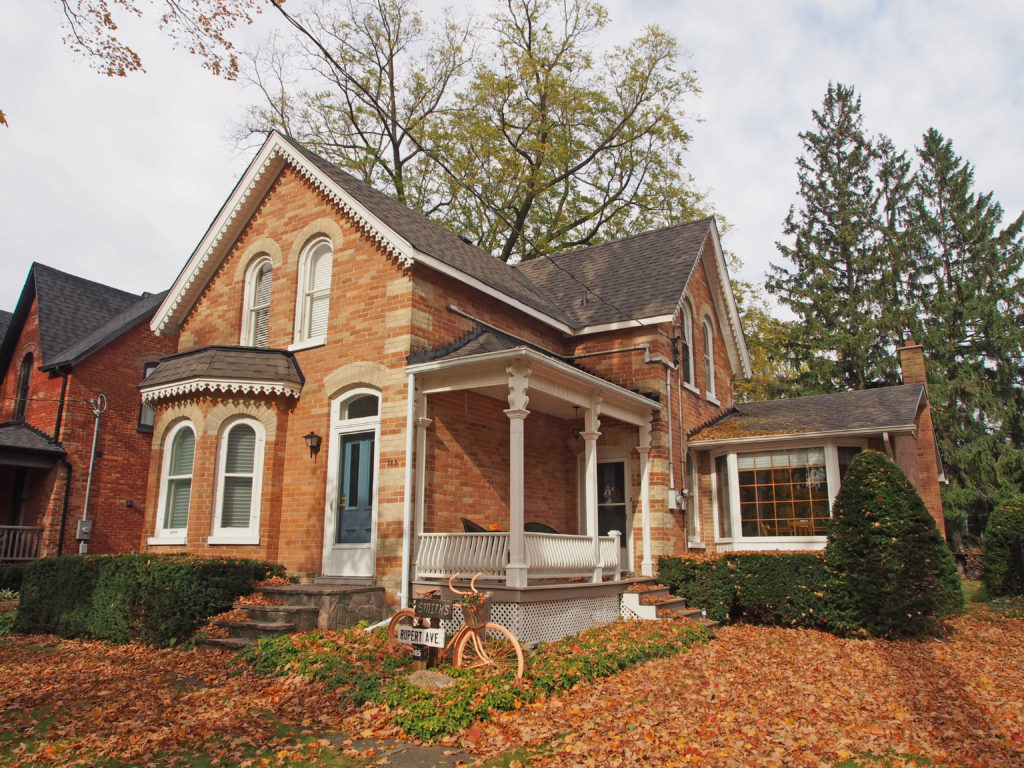
The Big Apple5 Toronto Street – three-story tower, cornice brackets65 King Street East – dormers, two-story open verandahKing Street East – paired cornice brackets, second floor balcony, sidelights and transom on front entrance9 Church Street East – In 1820, Joseph Abbott Keeler built this beautiful Neo-Classical house.5 Church Street East – two-story tower-like bay, second floor balcony3 Church Street East – hipped roof, cornice brackets8 Victory Street – During the reign of Queen Anne (1702-1714) an architectural style was born and it enjoyed a revival, particularly in the New World, in the latter part of the 19th century. 8 Victory Lane (as it was then known) is a fine example of this style of architecture. It is characterized by fine brickwork in warm, soft finished tones, terracotta panels and crisply painted white woodwork.3 King Street West – c. 1820 – Reputed to be among the oldest dwellings in Colborne, this was the home of Scottish immigrant John Steele and his wife Mary Spalding from 1831-1843. There is reason to believe the house predates 1820. Steele, a founder of Queen’s University held many other posts such as magistrate, newspaper editor, Board of Education trustee, member of literacy and agricultural societies etc. In 1843, the Steeles moved to Grafton and sold 3 King Street West to Cuthbert Cumming, a Hudson’s Bay trader. He sold it in 1858 to the Scougale family, local dry goods merchants, whose business was in the building next door. The Thorntons, part of the Scougale family, lived here for nine years of the Scougale clan’s 101-year occupancy.7 King Street West – c. 1830 – In 1846, Cuthbert Cumming and his wife Jane McMurray, acquired a portion of this two-acre property, and the balance in 1852. Cumming was born in Scotland and after working in the Canadian west and Quebec, he retired as a Chief Trader for the Hudson Bay Company. He remained in Colborne for many years, listed in the census records as “a gentleman†until his demise in 1870. The front elevation of this classic Regency Cottage with its low profile and deep roof overhang hides a secret. There are actually five levels, including a stone basement that housed the kitchen and servants in the mid-19th century.6012 King Road, Nobleton – Hambly House – c. 1884 – It was originally built of logs but was rebuilt after a fire at the corner of Highway 27 and King Road.
On January 1, 1971, the Village of Stouffville amalgamated with Whitchurch Township and was designated a community within the larger town of Whitchurch–Stouffville, a municipality in the Greater Toronto Area, about fifty kilometers north of downtown Toronto. It is more than two hundred and six square kilometers in size, and located in the mid-eastern area of the Regional Municipality of York on the ecologically-sensitive Oak Ridges Moraine and the Rouge River watershed. Its motto since 1993 is “country close to the city”.
Stouffville is the primary urban area within the town of Whitchurch–Stouffville. It is centered at the intersection of Main Street, Mill Street and Market Street. Stouffville was founded in 1804 by Abraham Stouffer who built a sawmill and grist-mill on the banks of Duffin’s Creek in the 1820s.
Urban Stouffville stretches from
the York-Durham Line to Highway 48 and is about 2.7 kilometers wide with
development north and south of Main Street. Stouffville is bounded by farmland
and a golf course. Uxbridge lies to the east.
Stouffville
Station was built in 1871 by Toronto and Nipissing Railway connecting Stouffville and
Uxbridge with Toronto. The line’s north-eastern terminus at Coboconk,
Ontario on Balsam Lake in the Kawarthas was completed in 1872. In 1877, a
second track was built from Stouffville north to Jackson’s Point on Lake
Simcoe. These connections were to provide a reliable and efficient means of
transporting timber harvested and milled in these regions. Stouffville
Junction serviced thirty trains per day. The railway became the Grand Trunk
Railway in 1884, and Canadian National Railways took over the line in 1914. Stouffville
Station was demolished in 1980s and replaced by current GO station.
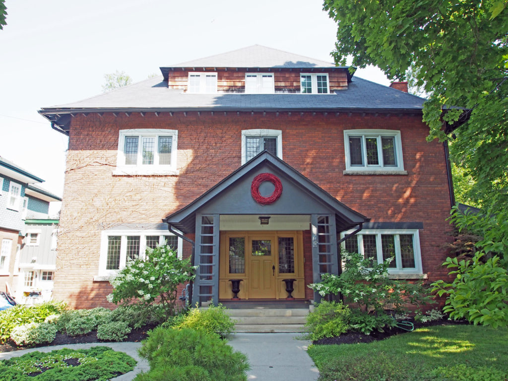
28 Mill Street – Neo-Colonial – gambrel roof52 Mill Street – Late Victorian Hybrid – verge board trim on gablesO’Brien Avenue – rounded verandah36 O’Brien Avenue – twin 2½-storey tower-like bays22 Church Street – c. 1880-1885 – Late Victorian Hybrid – built for Lucinda and R.J. Daley, a shoe merchant – corner quoins, bay window47 Church Street – c. 1890 – Late Victorian Hybrid with Italianate features, verge board trim and finial on gables, bay window, rounded verandah added in late 1920s – built by farmer William Mason for himself and wife Margaret Rae60 Church Street – c. 1891 – Romanesque Revival – long known as the David Stouffer house – he was a village historian and grandson of the founder of Stouffville, Abraham Stouffer – corbelled brick string courses around voussoirs, stained glass window transoms, second floor balcony72 Church Street – c. 1893 – Late Victorian Hybrid with Romanesque Revival and Italianate details – corbelled brick string courses around voussoirs, stained glass window transoms and sidelights, double story porch, dormer, decorative woodwork on brackets, gingerbread and porches80 Church Street – c. 1889 – 1½ story Gothic Revival – built for Isaac Broadway (a drugstore owner) and his wife 96 Church Street – c. 1890 – Romanesque/Queen Anne – built by Nathan Forsyth as his residence, local master builder – corbelled brick string course, balcony over verandah25 Duchess Street – c. 1885 – Late Victorian Hybrid with Queen Anne details – built for John and Thomas Casely -decorative brick, carved wooden fascia and porch, corner quoins, voussoirs, wooden post with capitals on ornately decorated porch for main entrance
Stouffville is the primary urban area within the town of Whitchurch–Stouffville. It
is centered at the intersection of Main Street, Mill Street and Market Street.
In 1805-06 Abraham Stouffer (1780-1851), a Pennsylvania Mennonite,
bought four hundred acres of land in the area and built a saw and grist mill on
Duffin’s Creek and a settlement grew up around it. In 1832 a post office named
Stouffville was established. By 1864, with a population of about seven hundred,
there were several prosperous industries including carriage works, harness
works, and the mills of Edward Wheler, a prominent merchant. The construction
of the Toronto and Nipissing Railway was completed in 1871 and growing
agricultural prosperity stimulated the community’s growth.
A large number of the early settlers of present-day
Whitchurch-Stouffville were members of the Historic Peace Churches: Brethren in
Christ (Tunkers), Mennonites, and Quakers. They were attracted to settle in
Upper Canada by Lieutenant Governor John Graves Simcoe with the offer of military
exemption (1793). The peace teachings of the Christian tradition greatly shaped
their faith and caused them to wrestle with what it means to be people of God’s
peace, especially during times of conflict and war. As pioneers of
conscientious objection in Canada, their commitment to the work of peace and
reconciliation continues to stand witness in this community and around the
world.
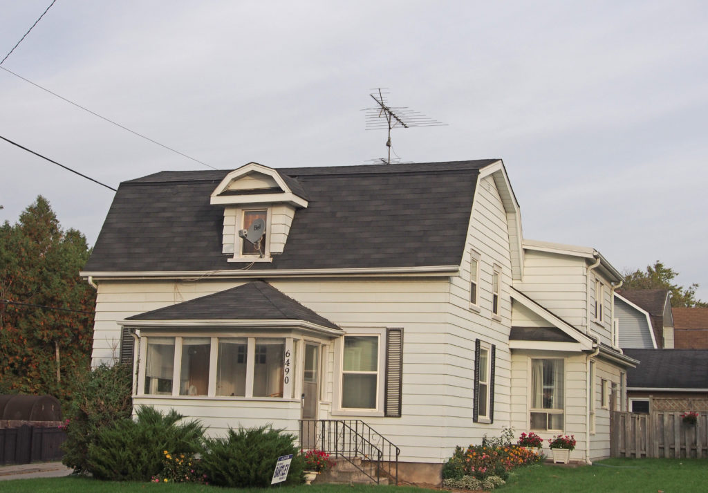
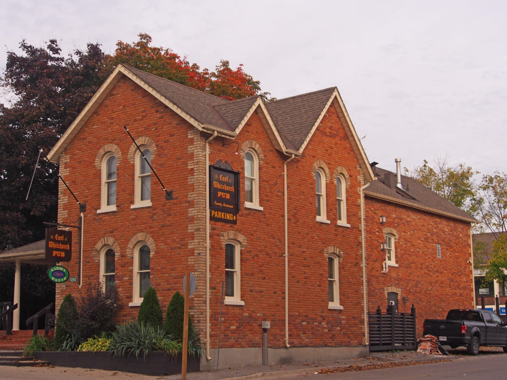
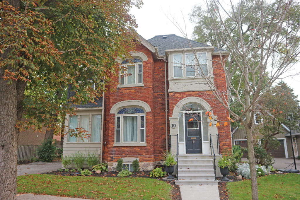
6731 Main Street – Late Victorian Hybrid – corner quoins, finials and trim on gables, voussoirs and keystones over windows6490 Main Street – Neo-Colonial – gambrel roof, dormer6465 Main Street – bay window6204 Main Street – The Earl of Whitchurch Pub – corner quoinsMain Street – Second Empire style – mansard roof, dormers with window hoods6128-6130 Main Street – two-story towers flanking the entrance, fretwork, dichromatic brickwork, contrasting voussoirs with keystones and drip molds over windows6139 Main Street – verge board trim on dormer, cobblestone veranda and pillars242 Rupert Avenue – c. 1892 – fretwork, bay window169 Rupert Avenue – Late Victorian Hybrid – bay window, contrasting window voussoirs, trim on peak of gable185 Rupert Avenue – Late Victorian Hybrid – quoins, bay windowRupert Avenue – Romanesque – window with sidelights and transom52 William Street – c. 1892 – verge board trim on gable, second floor balcony196 Second Street – steeply-pitched gables, transoms on lower level windows30 Albert Street – Italianate Villa – 1884 – It has a rare original semi-circular wood door.19 Albert Street – c. 1896 – Romanesque/Queen Anne – built for Joseph A. Todd, owner of the Todd block; he was a dealer in grain, flour, feed, coal, wood, seeds, potatoes, pork, corn, beans, felt roofing, salt in barrels, bulk lime, cement, plaster, fire brick, tile, wood, etc. He operated grain elevators at the train station and had his office in the corner store of the block on Main Street between Edward and Albert Streets.6 Albert Street – Built in 1878 for Jacob Raymer, a miller – Late Victorian hybrid with Italianate features