The City of Thunder Bay has three histories. The twin cities of Fort William and Port Arthur were amalgamated in 1970. Thunder Bay’s past is linked with the parallel but separate pasts of the two cities.
Port Arthur was a city in Northern Ontario which amalgamated with Fort William and the townships of Neebing and McIntyre to form the city of Thunder Bay in January 1970.
With Confederation in 1867, Simon James Dawson was employed to construct a road and route from Thunder Bay on Lake Superior to the Red River Colony. The depot on the lake, where supplies were landed and stored acquired its first name in May 1870. It was named Prince Arthur’s Landing in honor of Prince Arthur, son of Queen Victoria who was serving with his regiment in Montreal.
Prospering from the CPR railway construction boom of 1882–1885, Port Arthur was incorporated as a town in March 1884, one year after acquiring its new name. The CPR erected Thunder Bay’s and western Canada’s first terminal grain elevator on the bay in 1883. The end of CPR construction along the north shore of Lake Superior and the CPR’s decision to centralize its operations along the lower Kaministiquia River brought an end to Port Arthur’s prosperity. Silver mining had been the mainstay of the economy for most of the 1870s. The silver mining boom of the 1880s came to an end with the passage by the U.S. Congress of the McKinley Tariff in October 1890. The town was in dire economic straits until 1897–1899 when the entrepreneurs William Mackenzie and Donald Mann acquired the Ontario and Rainy River Railway and the Port Arthur, Duluth and Western Railway, and chose Port Arthur as the Lake Superior headquarters for the Canadian Northern Railway. Port Arthur thrived as a trans-shipment and grain handling port for the CNR after the railway line was opened to Winnipeg in December 1901.
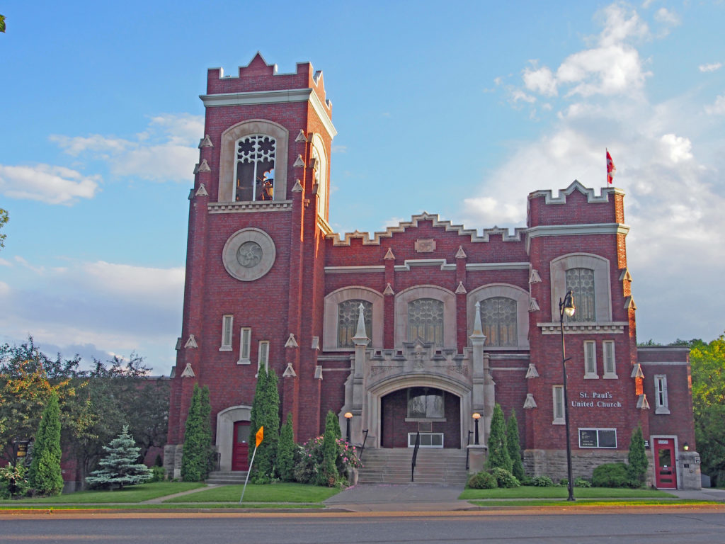
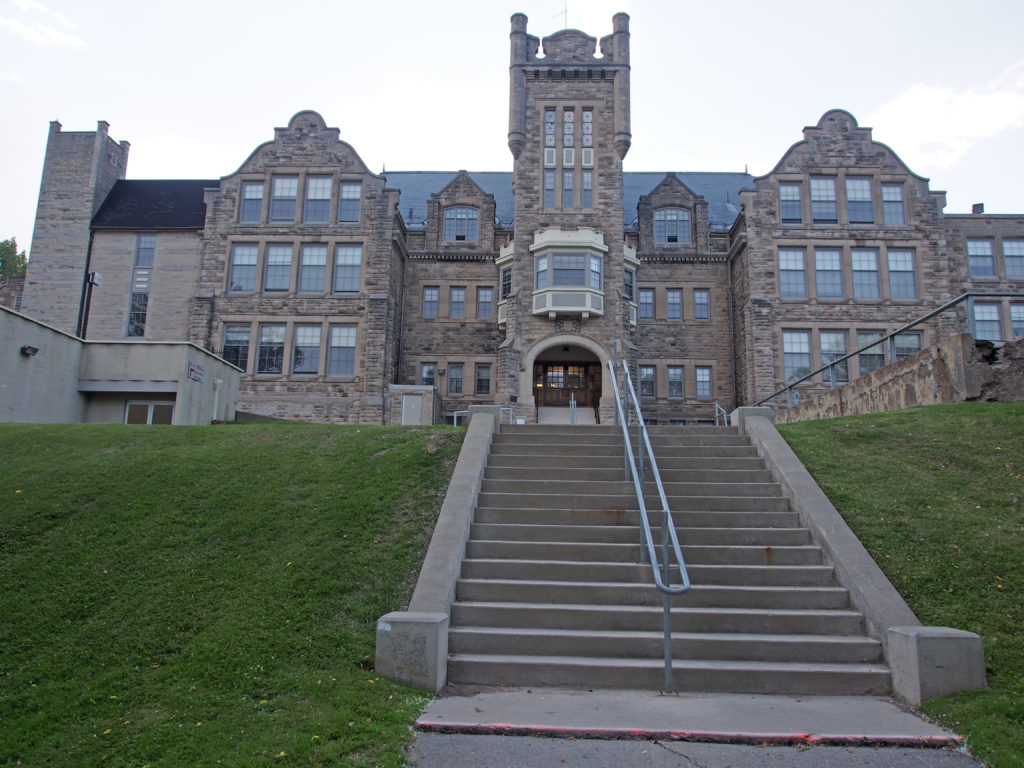
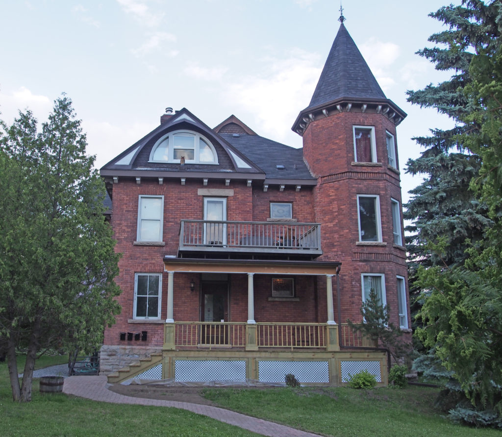
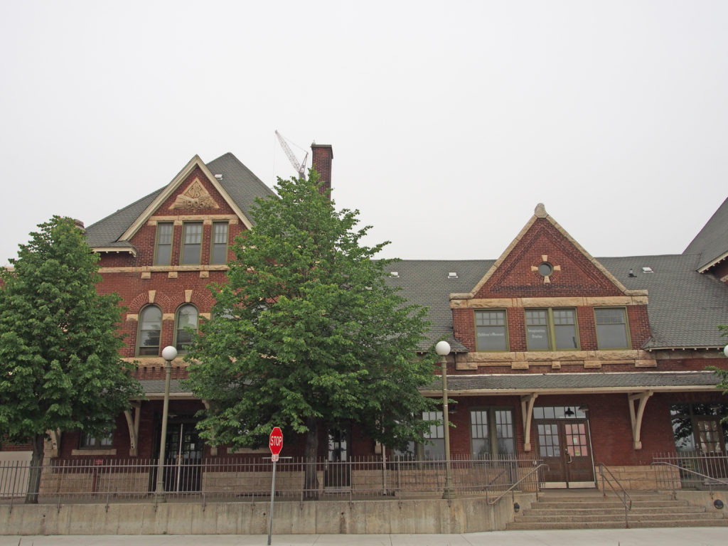
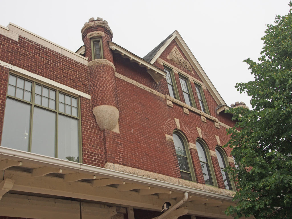
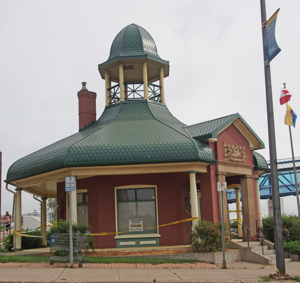
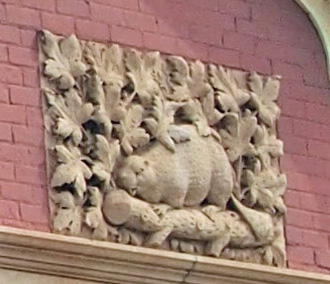
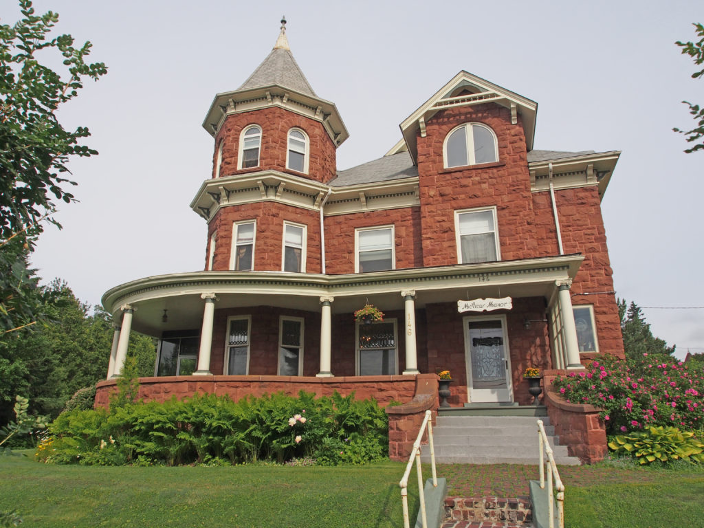
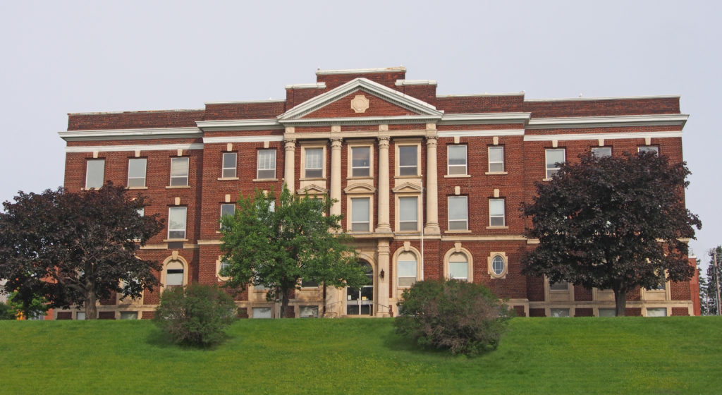
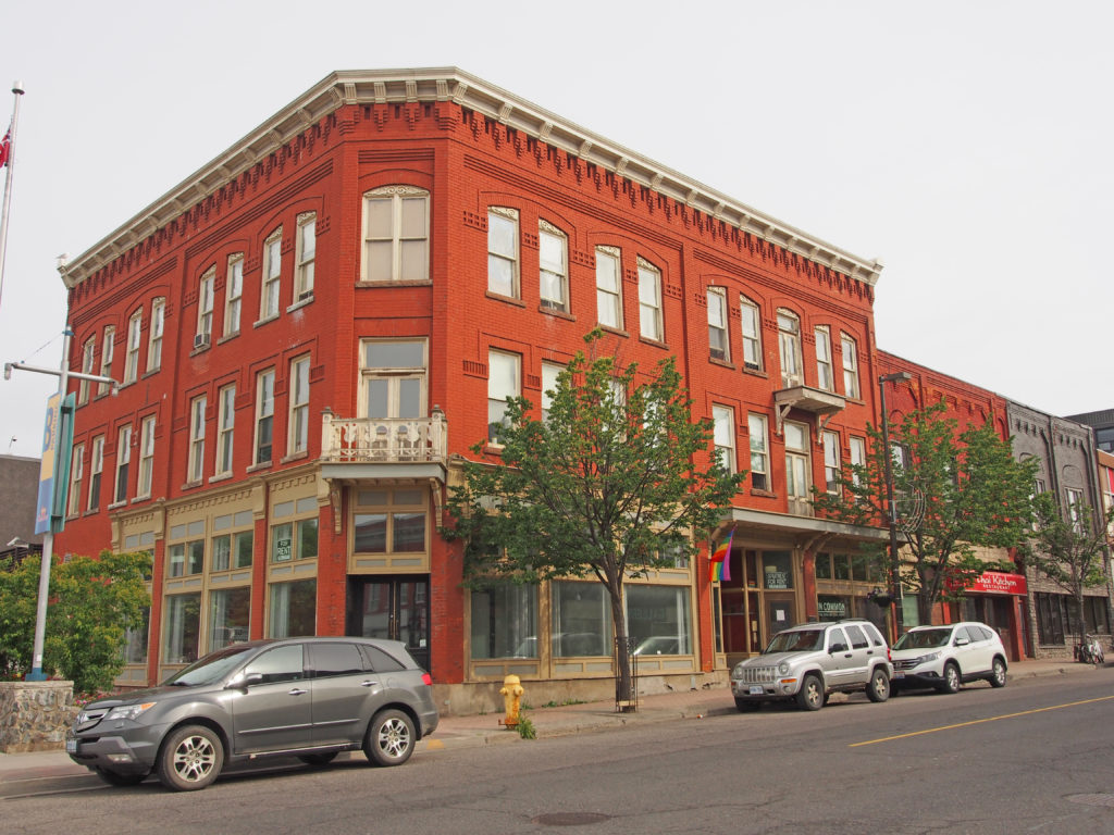
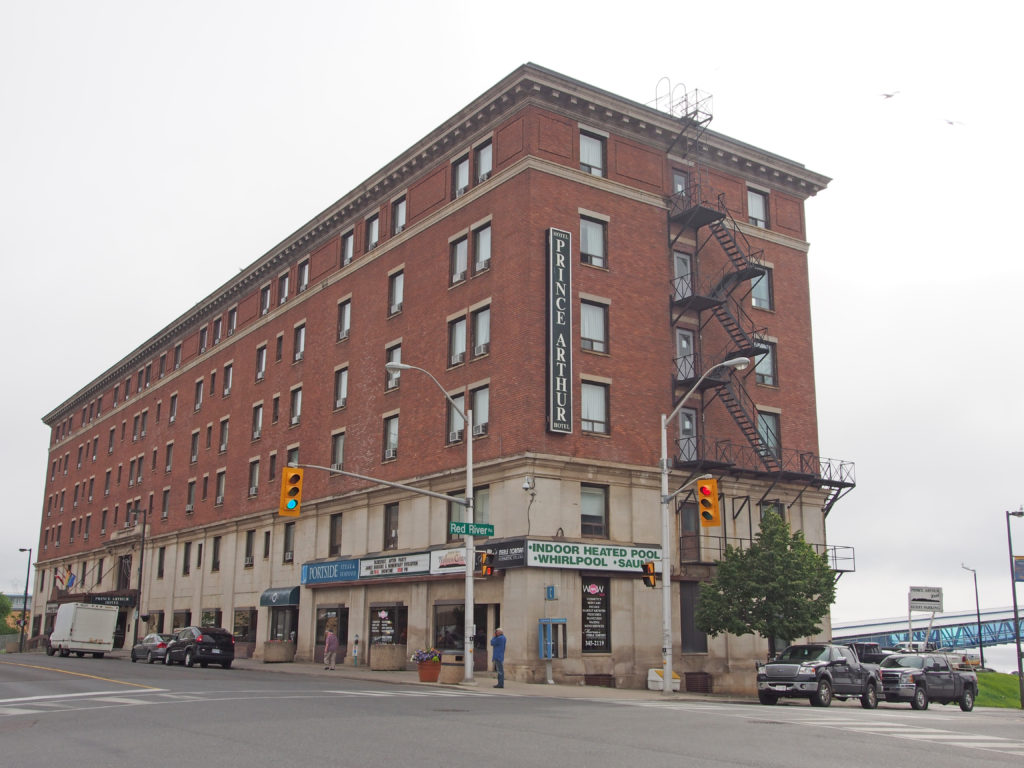
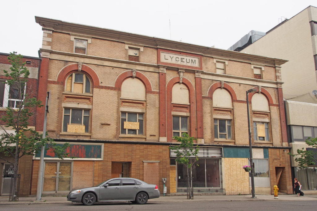
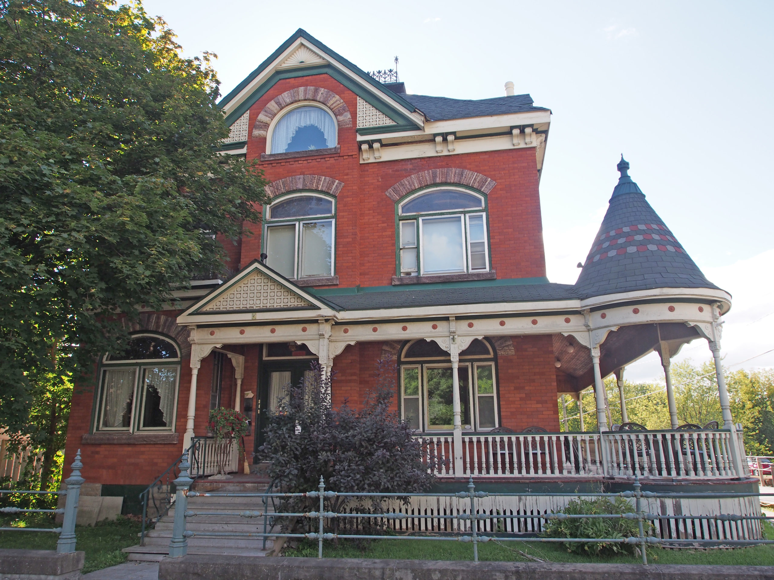
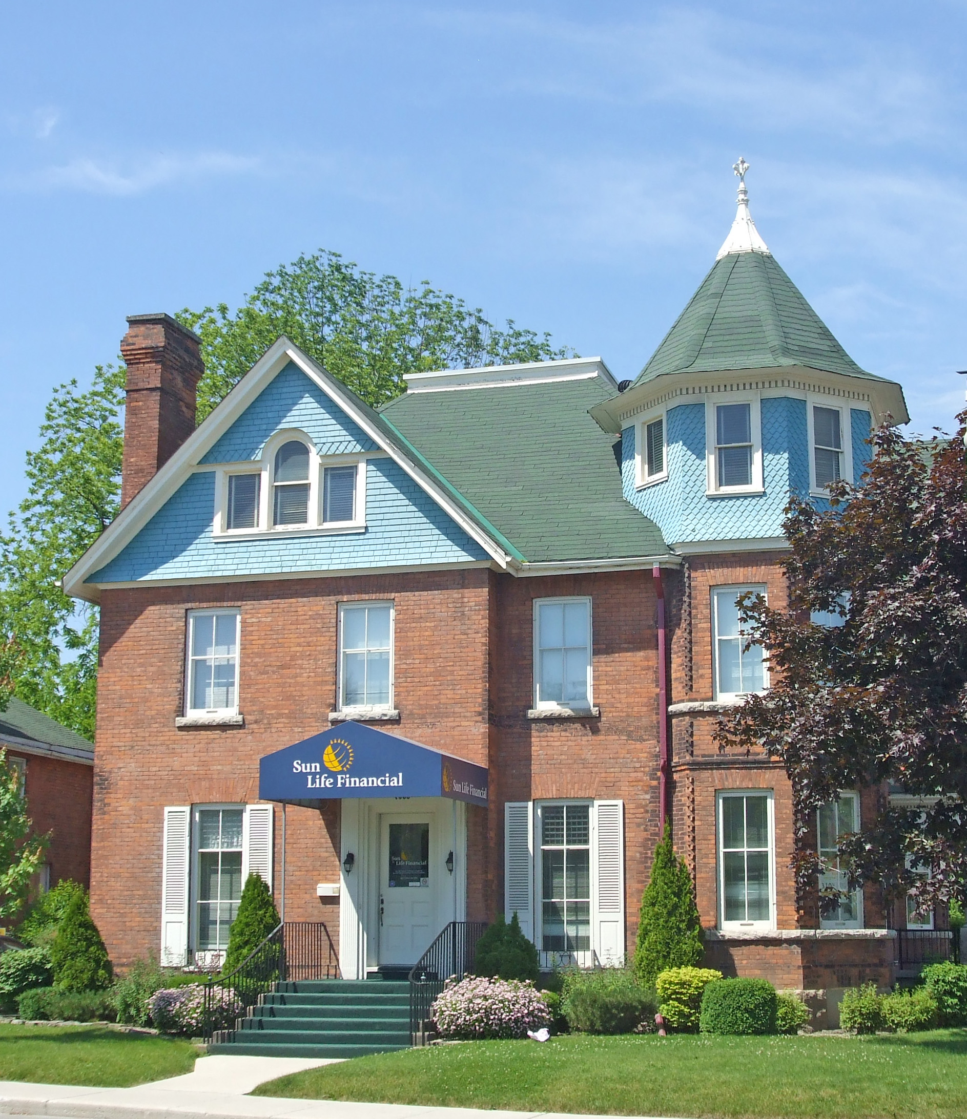
349 Waverley Street – St. Paul’s United Church was built in 1914 in mixed styles of Georgian (stone window surrounds) and Late Gothic Revival (double towers, buttresses, and geometrical tracery). The facade appears complicated because of the two different towers, the arched entrance portico with balcony above, the elaborate tracery, and the crenelations on the roof lines. Constructed of local red brick, white Bedford limestone is used for accent. A wide segmental arch with molding frames the covered entry; the doors are placed to the right and left, in the base of the towers. Above the arch there are spandrels filled with floral relief ornament. The piers to either side of the arch conclude with tall pointed finials. The north wall above the balcony has three large segmental arched windows with stone surrounds. Shallow stepped buttresses in brick with triangular capstones separate the windows. The honeycomb window tracery is applied to the windows rather than the structure. A date stone, 1913, is located above the window. – Book 1401 Red River Road – Port Arthur Collegiate Institute was constructed in 1909 of Simpson Island stone in the Queen Anne style. Due to decreasing enrollment, the school was closed in 2007. Lakehead University purchased the building and it is now the Bora Laskin Faculty of Law. Originally symmetrical, the school has a four-story central tower flanked by two three-story wings. The curved step-gables of the wings repeat the curved crenelations atop the tower. Rounded battlements project from the topmost corners of the tower and oriel windows from the second level. The entrance is on the first floor of the tower and reached through a round arch. Both the tower and the wings have buttresses at the corners. – Book 1Red River Road – Queen Anne style with a three-story tower with string courses between the windows; there are cornice brackets below the octagonal roof, and along the rest of the roof line; there is a second floor balcony above the veranda. – Book 19 Water Street North – The Canadian National Railway Station was constructed in 1906 in the Chateauesque style. Brick is used on a symmetrical plan with Tyndall limestone used in the foundation and for decorative elements. The solid symmetrical arrangement of the masses and windows, combined with the Scottish Baronial style (the most noticeable characteristic of which is the bartizan, an overhanging corner turret), very high pitched roofs, multiple dormer windows, and crenelated turrets qualify this building as being a prime example of the “Railroad Gothic style†developed by the railway companies at the beginning of the twentieth century and is uniquely Canadian. The plan of this brick building with pitch-faced limestone trim consists of a long, low, gabled central section. The large square end towers have centrally hipped roofs. The towers each have a central gable with three square-headed windows under one lintel course, with a string course, supported by stone corbels, at the windowsill level. Above the windows there is a triangular tablet bearing a wheat sheaf, the letters CNR and the date 1905, in relief. The second story contains a triplet of round-headed windows with stone imposts and keystones; at the windowsill level there is a string course supported by a brick corbel table. The second story of the central section consists of a parapeted gable with a bull’s eye window below it. There is a frame canopy over the first story across the full length of the east wall; it is supported on frame brackets that rest on stone corbels. All the corners of the building have quoining. There is a tall brick chimney on the east slope of the roof over the central section. – Book 29 Water Street North end – The tower corners have bartizans with loophole windows, and stone bottoms and battlements.170 Red River Road – The Pagoda Visitor Centre was constructed in 1909. It was built specifically to capture the attention of visitors to Port Arthur. It is an eclectic mixture of Roman, Greek (the peristyle formed by the columns surrounding the outside of the building which support the roof and is characteristic of basic elements of western architecture), Indian Islamic (mushroom or umbrella-shaped roof) and Scandinavian architecture. The cupola on top of the roof was originally designed so that bands could play to welcome visitors. Above the entrance is a large carved stone panel with a beaver and maple leaves. – Thunder Bay Book 2170 Red River Road – Above the entrance is a large carved stone panel with a beaver and maple leaves.146 Court Street North – McVicar Manor Bed and Breakfast is a 1906 Edwardian red brick home with three spacious rooms. It has a three-story turret, and a two-and-a-half tower-like bay, cornice brackets, Ionic pillars supporting a wraparound veranda. – Book 2277 Camelot Street – The District Court House was constructed in 1924 in the Classical Revival style. The building is symmetrical and is constructed of structural steel with brick walls. The imposing exterior of the building includes the Classical pediment above the main entrance which is supported by four Corinthian columns. The white Tyndall limestone used for the columns, sills and the window casement rim contains visible fossils. – Book 238-40 Cumberland Street South at the corner of Lincoln – The former Ottawa House hotel is a distinctive three-story business block constructed of red brick in 1888. There is a wooden cornice at the roof line, decorative brick brackets which visually extend the cornice, and rectangular areas of patterned brickwork between the windows. Splayed brick forms an arch between the pairs of windows and the single window on the third-floor windows, and there are brick voussoirs above the second-story windows. There is a second-floor balcony above the corner entrance. The hotel was advertised as having fifty rooms, baths, a steam furnace, and electric light. – Book 217 Cumberland Street North – The Prince Arthur Hotel was built in 1911. The rooms were well heated and lighted; each one had hot and cold running water. The cost of a room for the night was as low as one dollar. Most early visitors to the Lakehead arrived by steamship or by rail, and disembarked at the stations near the Prince Arthur. The hotel was constructed of brick and stone and had a marble staircase. Six stories high, the building has prominent lintels above all upper floor windows, impressive massing, and decorative brick work on the top story. There are slightly projecting pilasters on the stone portion of the building and a cut stone string-course between the fifth and sixth stories. The original lake side entrance had formal terraced gardens and lawns that cascaded down to the Canadian Pacific Railway Station. The hotel was expanded in 1912 and again in 1920. A dining room, barbershop, newsstand, washrooms, writing room, balcony and extra wings were added. – Book 212-22 Cumberland Street North – The Lyceum Theatre was built in 1909 to accommodate traveling shows and then later it was a movie theatre; now it is several offices and stores. Some of the significant architectural features are keystones with bearded faces, segmented semi-circular windows, and a large stone panel in the center of the facade with the name LYCEUM in large letters. The building is steel framed with brick facing and stone trim. – Book 2
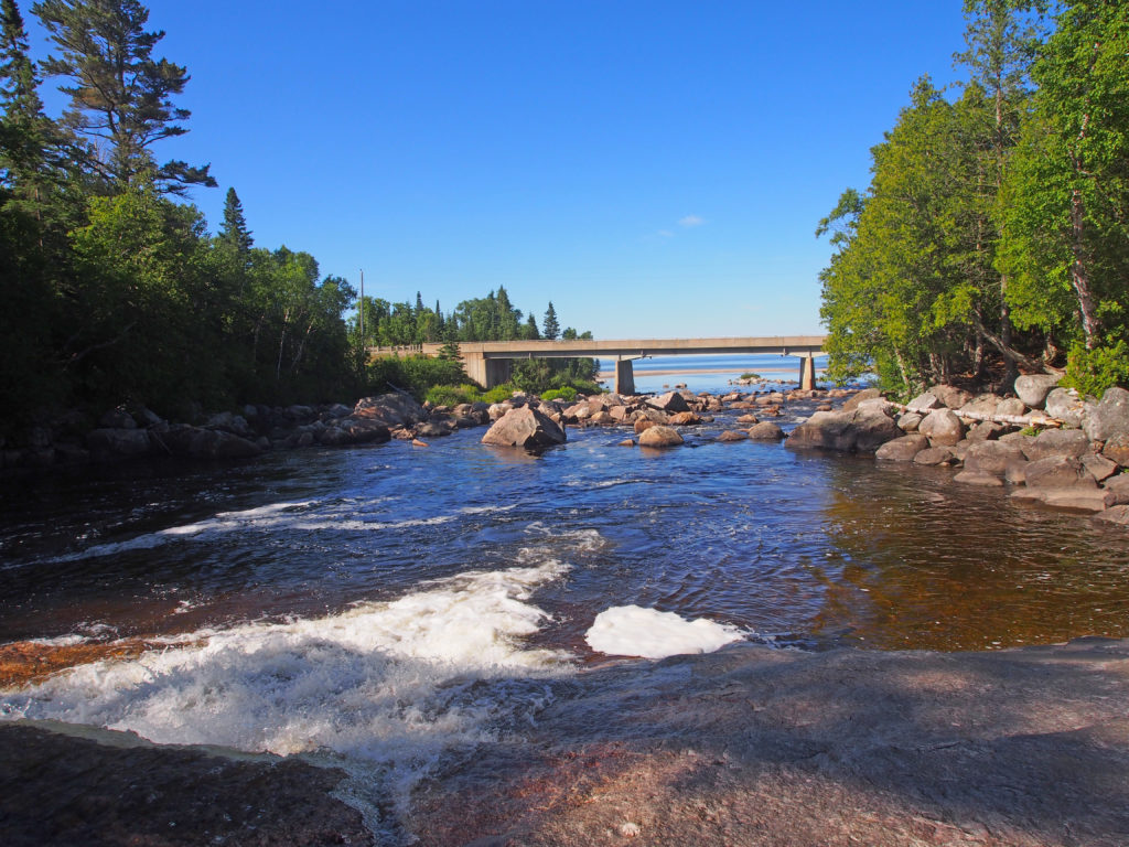
Lake Superior is the largest freshwater lake in the world by surface area, and the third largest in volume. If the coast of Lake Superior was unraveled into a highway, it would extend 2,939 kilometers (1826 miles). The deepest spot is 406 meters (1,322 feet). Lake Superior presented many challenges to shipping. As interest in the resources of the north grew, investors wanted a more reliable form of transportation and the Algoma Central Railway was built. It was intended to bring iron ore and pulp logs from Wawa and Hearst to the mills of Sault Ste. Marie. With the completion of the railroad in 1914, loggers, tourists and artists traveled to places that had been difficult to reach.
Before Lake Superior Provincial Park was created, a group of artists came to paint pictures of Canada. J.E.H. MacDonald found a multi-channeled falls which he painted showing the foam, the reflections, the colors and the magic. These artists were experimenting with new techniques that showed the ruggedness and beauty of the land. Each fall between 1918 and 1922, members of the Group of Seven painted the newly accessible landscape of the Algoma region as the railway was built. They lived in a rented boxcar and traveled up and down the railway in a three-wheeled handcart called a velocipede. A canoe took them to locations away from the track. The bold new style of painting used vibrant colors.
The Agawa River Valley formed a natural pathway through the wilderness; a section of the railway follows the route through the Agawa Canyon.
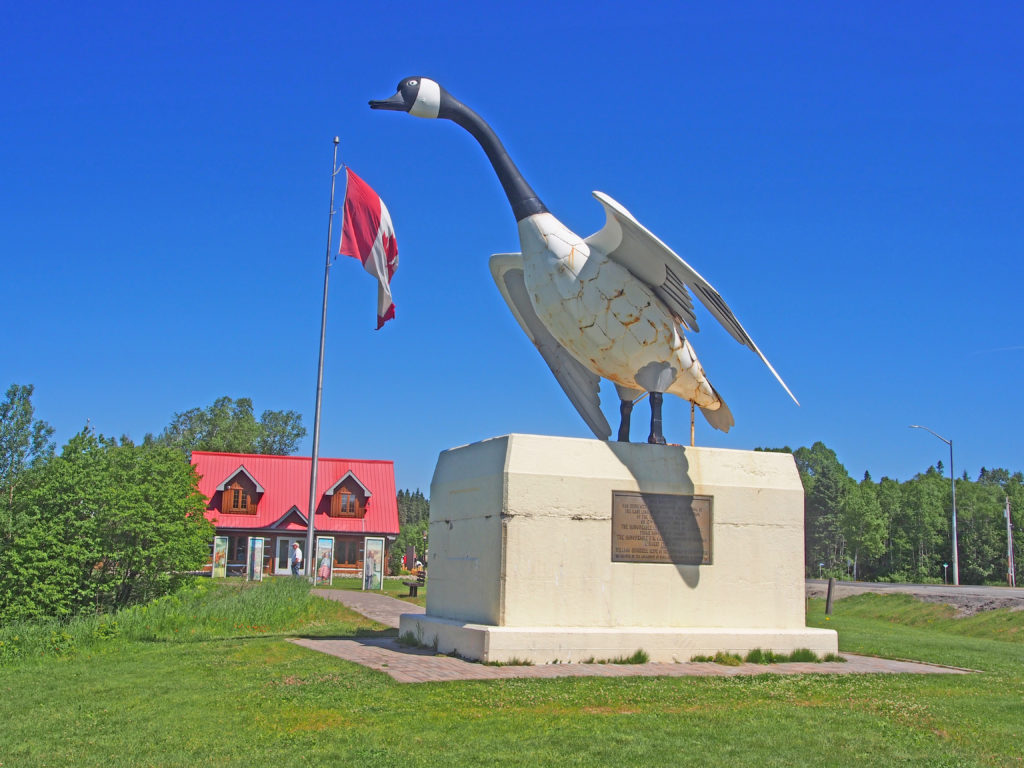
When the first Europeans traveled to the Wawa region in the late 1600s, they were introduced to a rugged landscape occupied by the Ojibway people. Wawa means clear water. Somewhere along the way wawa may have been mistranslated to wild goose instead of wewe which means snow goose. The wild goose story stuck and thus was born Wawa’s legendary Wawa Goose.
Kenora is a small city situated on the Lake of the Woods in Northwestern Ontario, close to the Manitoba border. It is about two hundred kilometers (124 miles) east of Winnipeg. Kenora’s future site was in the territory of the Ojibway when the first European, Jacques de Novon, sighted Lake of the Woods in 1688. Pierre La Verendrye established a French trading post, Fort St. Charles, to the south of present-day Kenora near the current Canada/United States border in 1732, and France maintained the post until 1763 when it lost the territory to the British in the Seven Years’ War. In 1836 the Hudson’s Bay Company established a post on Old Fort Island, and in 1861, the Company opened a post on the mainland at Kenora’s current location.
In 1878, the company surveyed lots for the permanent settlement of Rat Portage (“portage to the country of the muskrat”) — the community kept that name until 1905, when it was renamed Kenora. Gold and the railroad were both important in the community’s early history: gold was first discovered in the area in 1850, and by 1893, twenty mines were operating within 24 kilometers (15 miles) of the town. The first Canadian ocean-to-ocean train passed through in 1886 on the Canadian Pacific Railway. A highway was built through Kenora in 1932, becoming part of Canada’s first coast-to-coast highway in 1943, and then part of the Trans-Canada Highway. In 1967, the year of the Canadian Centennial, Kenora erected a sculpture known as Husky the Muskie. It has become the town’s mascot and one of its most recognizable features.
A dramatic bank robbery took place in Kenora on May 10, 1973. An unknown man entered the Canadian Imperial Bank of Commerce heavily armed. After robbing the bank, the robber was preparing to enter a city vehicle driven by undercover police officer Don Milliard. A sniper positioned across the street shot the robber causing the explosives he was carrying to detonate and kill the robber. Most of the windows on the shops on the main street were shattered as a result of the blast.
Dryden is the second-largest city in the Kenora District of Northwestern Ontario. It is located on Wabigoon Lake. The Dryden area is part of the Ojibway nation, which covers a large area from Lake Huron in the east to Lake of the Woods and beyond. The Ojibway are nomadic with groups from family to village size moving over the land with the seasons and the availability of game or the necessities of life. The settlement was founded as an agricultural community by John Dryden, Ontario’s Minister of Agriculture in 1895. While his train was stopped at what was then known as Barclay Tank to re-water, he noticed clover growing and decided to found an experimental farm the following year. The farm’s success brought settlers from other areas and the community came to be known as New Prospect. Pulp and paper came to the town in 1910. Today, its main industries are agriculture, tourism and mining. The town was the site of the March 10, 1989 crash of Air Ontario Flight 1363 which killed twenty-four people. Dryden is known by people passing by as the home of “Max the Moose”, Dryden’s 5.6 meters (18 foot) high mascot on the Trans-Canada Highway.
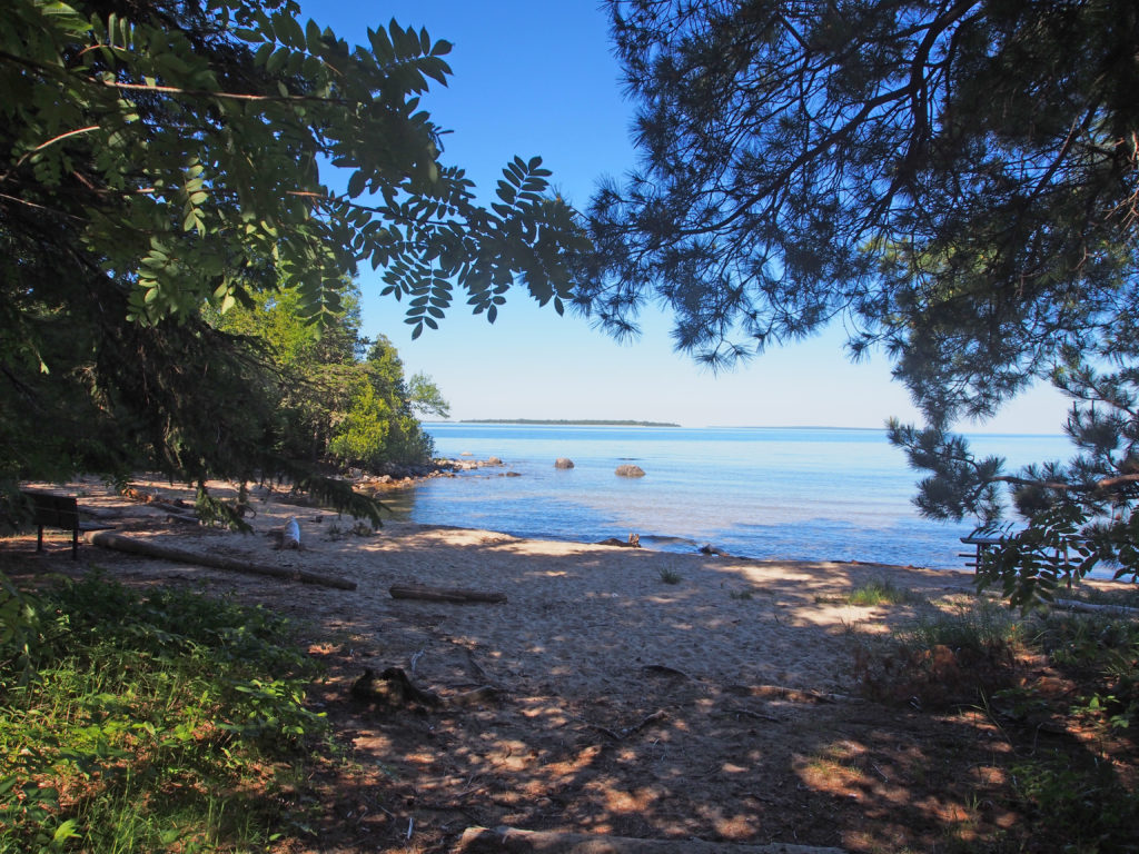
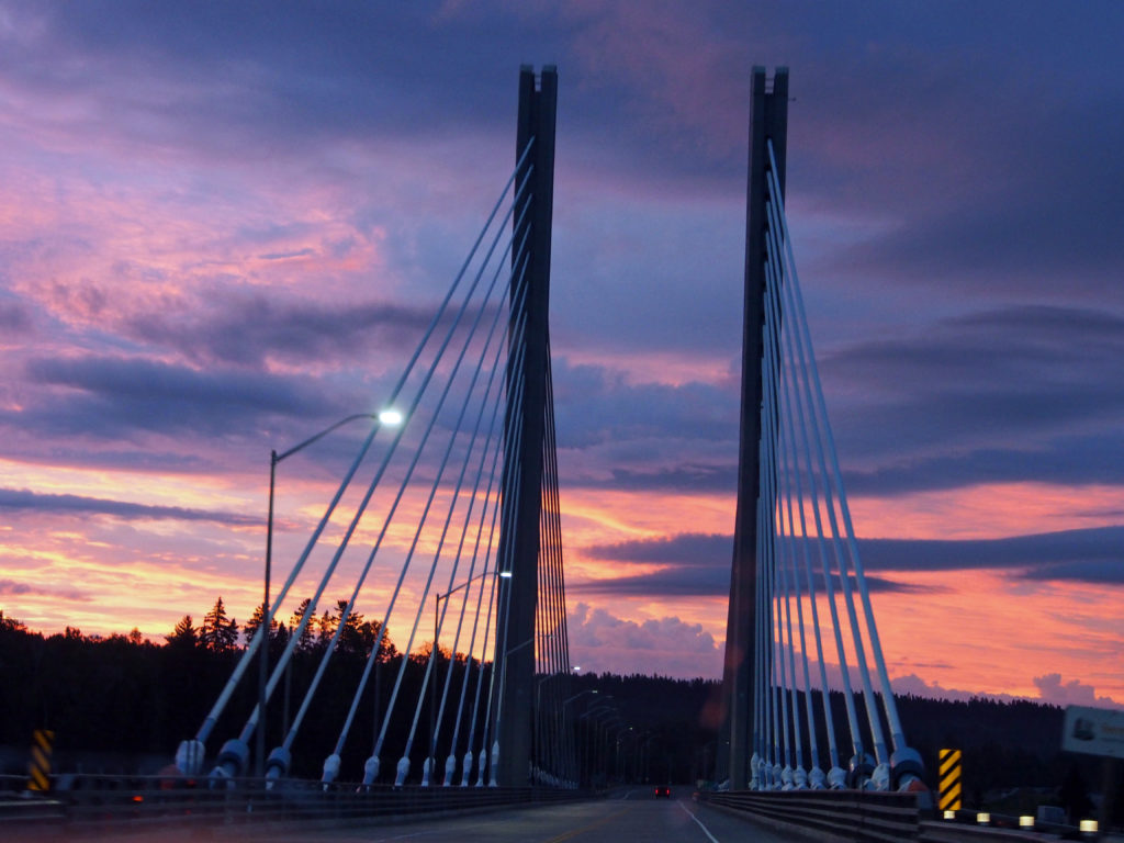
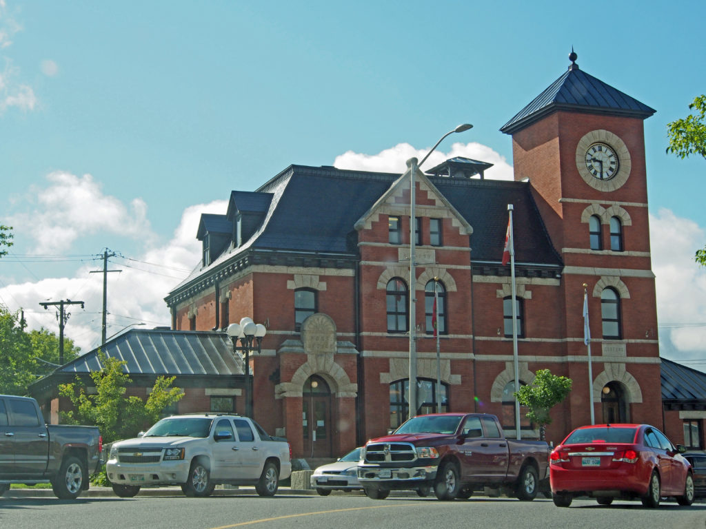
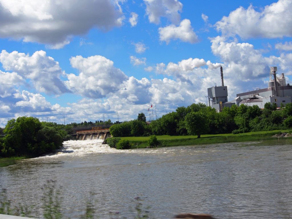
Lake SuperiorLake SuperiorTo the Ojibway, this river of fine white sand was known as Pinguisibi. Here in the shelter of the Lizard Islands, the waters are warmer and shallower. The sand beaches of Katherine Cove are a great place for relaxing and having a picnic.The famous Wawa Goose gazes out over the Trans-Canada Highway as it carries traffic through the Magpie River Valley. The Magpie River travels about one hundred and thirty kilometers over a number of scenic waterfalls (Steephill Falls, Magpie High Falls, and Silver Falls) until it merges with the Michipicoten River half a kilometer from its mouth on Lake Superior.Nipigon Bridge at sunsetKenora Post Office – A.D. 1898 – Second Empire style – mansard roof with dormers, dichromatic brickwork, banding, three-story clock towerDryden
Smiths Falls is a town in Eastern Ontario located fourteen miles east of Perth. The Rideau Canal waterway passes through the town, with four separate locks in three locations and a combined lift of over fifteen meters (fifty feet). The city is named after Thomas Smyth, a United Empire Loyalist who in 1786 was granted 400 acres here. In 1846, there were fifty dwellings, two grist mills (one with four run of stones), two sawmills, one carding and fulling mill, seven stores, six groceries, one axe factory, six blacksmiths, two wheelwrights, one cabinet maker, one chair-maker, three carpenters, one gunsmith, eleven shoemakers, seven tailors, one tinsmith and two taverns.
At the time of construction of the Rideau Canal a small settlement had been established around a mill operated by Abel Russell Ward, who had bought Smyth’s land. Colonel By ordered the removal of Ward’s mill to make way for the canal. The disruption of industry caused by the building of the canal was only temporary, and Smiths Falls grew rapidly following construction.
The Rideau Canal area is home to a variety of ecosystems. The land along the Rideau that was once logged is now home to deep-rooted deciduous and coniferous forests that have been maturing for over one hundred years. Where the landscape flattens, there are cedar/hardwood swamps, bogs and cattail marshes which support the healthy wildlife population.
110 Elmsley Street North – 2½-storey tower-like bay with pediment and fretwork; dormer16 Maple Avenue – Victorian Cottage style – c. late 1890s – double bay windows, high gables decorated with detailed wood trim and finials, fretwork, voussoirs and keystones, dichromatic brickwork and banding; upper exterior porch; elegant entrance40 William Street – Victorian – iron cresting around balcony above bay window; turned veranda roof supports with decorative capitals and spindlesRussell Street East corner of Market Street – Trinity United Church – 1886 – Queen Anne style – three non-symmetrical towers, various shaped windows, rose window, beveled dentil molding84 Lombard Street – Gothic – finials and trim on gables, corner quoins, voussoirs with keystones, second floor balcony; bay window with cornice brackets; turned spindle roof supports for veranda78 Brockville Street at corner of Lombard Street – built by Ogle Carss, an early mayor of the town – 1895 – Queen Anne Revival style – irregular outline, broad gables, multi-sloped roofs, a belvedere, a tower, ornamental cast iron railings on the roof; long, graceful wraparound verandah; stone voussoirs over semi-circular windows with transoms102 Brockville Street – Italianate – steeply pitched hip roof with dormer; cornice brackets, voussoirs; turned veranda roof supports with decorative capitals, open railing; pedimentBascule Bridge – located west of the Detached Locks – a rolling-lift railway bridge built in 1914, now in a permanently raised position – it works like a seesaw – on one end a hinged counter weight drops causing the other end to rise – it was the solution to the point where the railway and canal intersected
Sault Ste. Marie is a city on the St. Marys River close to the US-Canada border. To the south, across the river, is the United States and the city of Sault Ste. Marie, Michigan. These two communities were one city until a treaty after the War of 1812 established the border between Canada and the United States in this area at the St. Mary’s River. Today the two cities are joined by the International Bridge. Shipping traffic in the Great Lakes system bypasses the Saint Mary’s Rapids via the American Soo Locks, the world’s busiest canal in terms of tonnage that passes through it, while smaller recreational and tour boats use the Canadian Sault Ste. Marie Canal.
Before there was a Soo Locks, or even houses and stores, the place we call “the Sault†was a land covered by trees. The people living in this place called themselves “Anishinabeg,†which means “The People.†They were Woodland Indians whose homes, clothing, food and tools were all made from the plants and animals they found in the woods and water around them. Where the Soo Locks are today, the river that we now call the St. Marys had huge rocks scattered across it.
French colonists referred to the rapids on the river as Les Saults de Ste. Marie and the village name was derived from that. The rapids and cascades of the St. Mary’s River descend more than twenty feet from the level of Lake Superior to the level of the lower lakes.
Each spring several large canoes paddled by men from the Montreal area called voyageurs came to the Sault from Montreal. With the voyageurs, came traders from the large fur companies of Montreal and tons of goods to be traded for the furs that the Chippewas had trapped during the winter. Among the trade goods were guns, metal knives and traps, pots and pans, blankets, beads and cotton material. Beaver furs were used to make fashionable men’s hats in Europe.
420 Queen Street East – Ministry of the Attorney General Court House was completed in 1922 in the Beaux Arts Classical style. It shows fine workmanship, good material and attention to details. The imposing, symmetrical, three-storey structure is built of orange-brown stone and brick. It is set back from the street on an elevated site and approached by a circular driveway. Its temple front facade consists of Ionic columns supporting a brick pediment.
3-7 Queen Street East – Built at the turn of the century, the Barnes Block combines a Gothic corner turret with a late Victorian Italianate north façade. A mortar and pestle which rise from the truncated roof are a reminder that the building was originally built as a drug store.
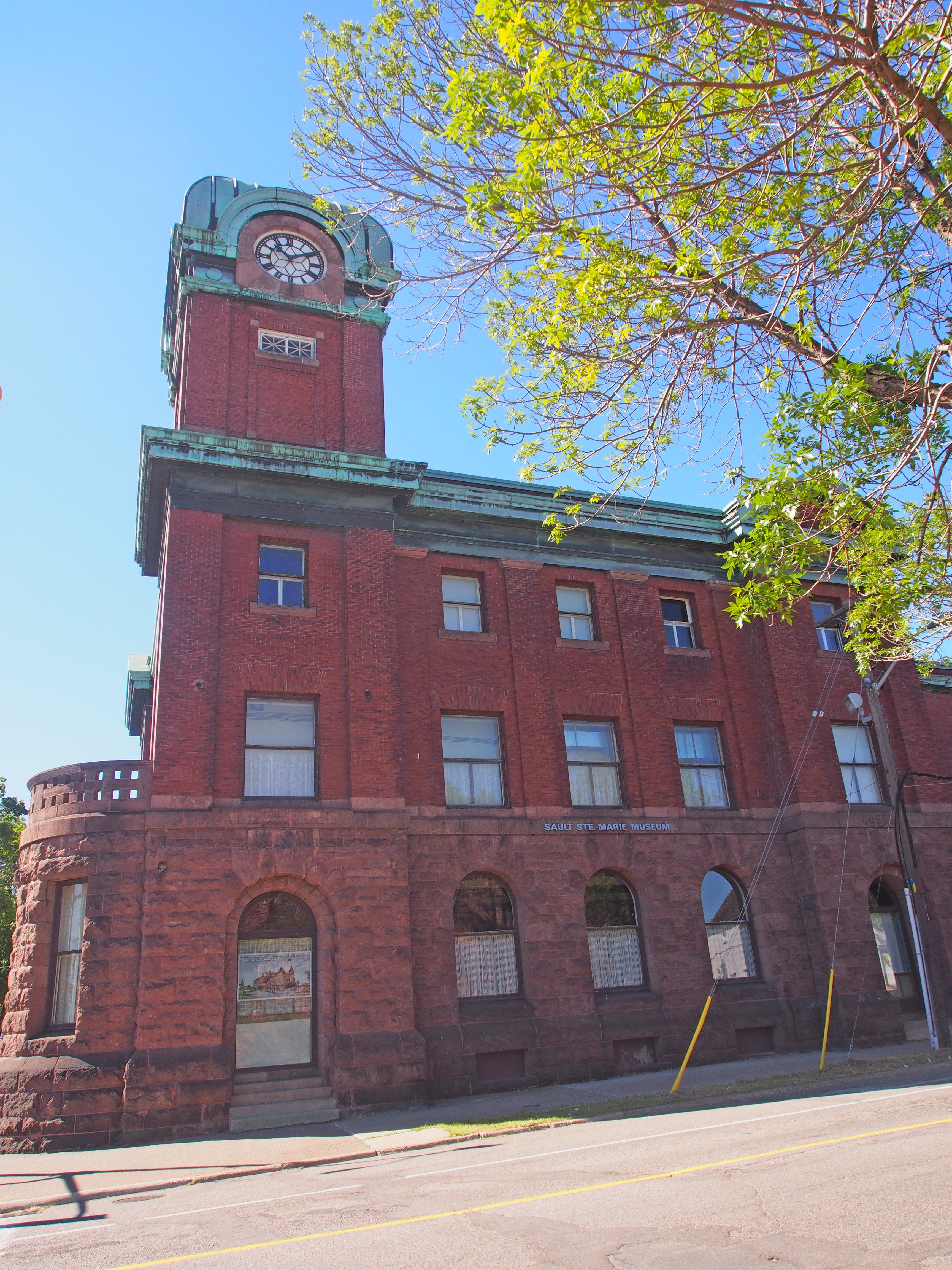
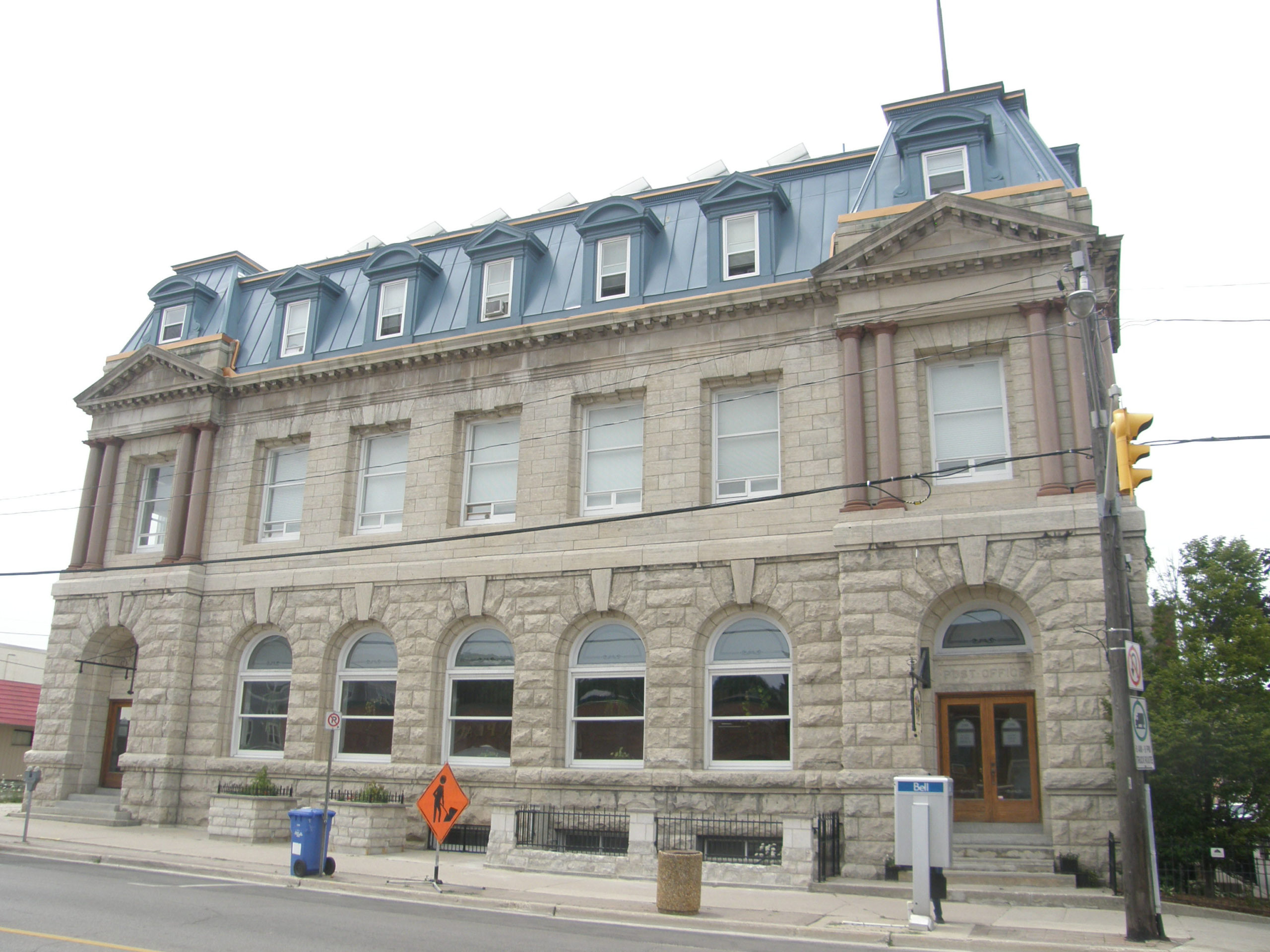
690 Queen Street East/107 East Street – Sault Ste. Marie Museum – The Old Post Office is an imposing three storey red brick and stone building featuring a clock tower. It is prominently located in downtown Sault Ste. Marie at the intersection of Queen Street East and East Street. Built between 1902 and 1906 as a federal building, it was purchased in 1982 by the City for use as the Sault Ste. Marie Museum. It is a fine example of turn of the century Federal architecture in Ontario, combining Victorian classicism with excellent workmanship. Exterior elements include classical pediments, pilasters and cornices, Romanesque stone arches with Italianate detailing and decorative features. Inside there is an oak staircase, an exquisite three-story light well and skylight, and a plated glass floor.
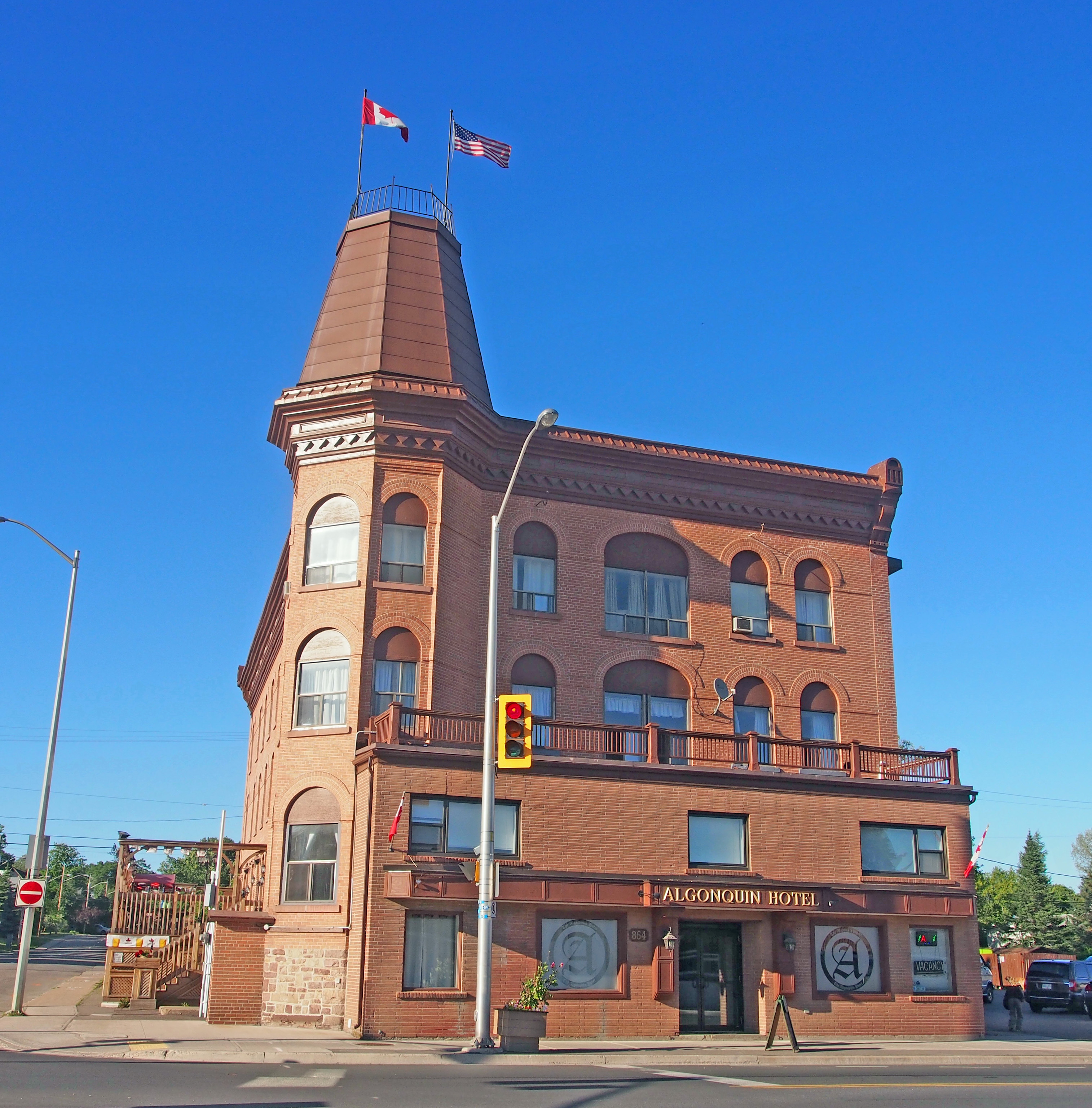
864 Queen Street East – Built in 1888, the Algonquin Hotel is a four-storey brick structure located in close proximity to the north shore of the St. Marys River on the northwest corner of Queen Street East and Pim Street. The Algonquin is the sole survivor of the large hotels built close to the turn of the twentieth century to cater to a rapidly expanding industrial center. These hotels were clustered around Sault Ste. Marie’s docks to serve arriving settlers and workers. The hotel is a good example of Victorian commercial architecture. Key elements that reflect the architectural style are the use of brick masonry, including the masonry arches over the windows, the truncated tent roof which caps the southwest polygonal corner of the hotel, the painted metal cornice on the Queen Street and Pim Street facades, and the chevron molding on the Queen Street and Pim Street cornices.
831 Queen Street East – The Ermatinger Old Stone House is a two-storey stone structure built on the north bank of the St. Mary’s River near the rapids in Sault Ste. Marie. The house provides a link to Sault Ste. Marie’s role in the fur trade and to one of its earliest settlers. Charles Oakes Ermatinger, a member of a prominent Montreal family who joined the Northwest Company and married Charlotte Katawabeda, the daughter of the Paramount Chief of the Ojibway, built the house in 1812-1814 of local red sandstone in a style characteristic of vernacular Georgian architecture but employed Quebec construction techniques. The house quickly became the center of government in the northwest part of the province and of the business and social life of the district. It later served as the first courthouse, a post office and a hotel. The house served as the headquarters of Sir Garnet Wolseley in 1870 when the expedition he commanded stopped at Sault Ste. Marie enroute to quell the Red River Rebellion and to establish Canadian sovereignty over Manitoba and the Northwest Territories.
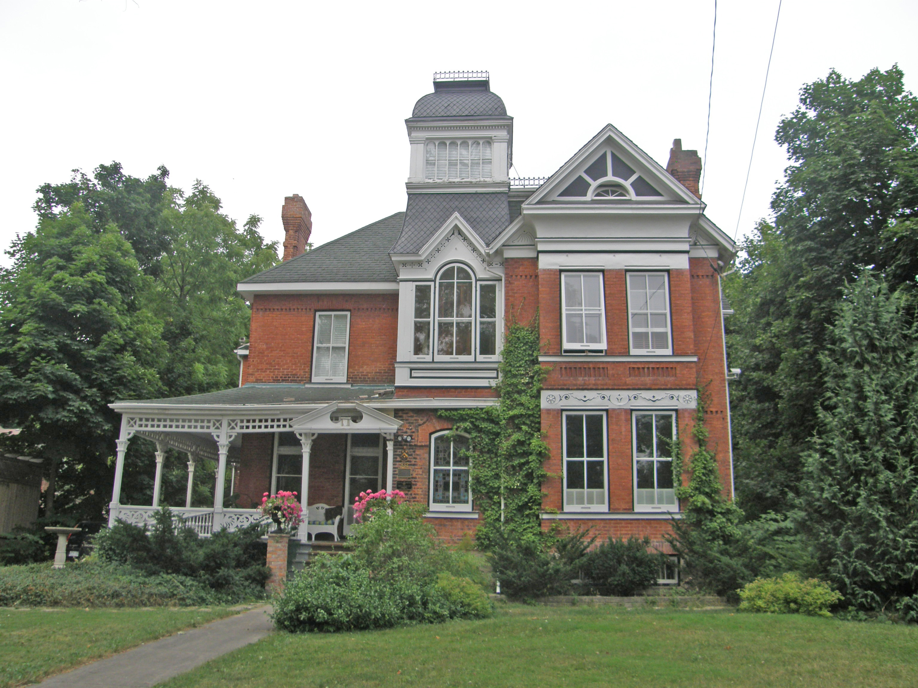
115 Upton Road – Built in 1902 as a family residence, the asymmetrical composition, turret and the variety and complexity of detail seen in the spindle work, porch supports and gable ends are typical of the Queen Anne style. It is a substantial, gracious and elegant framed dwelling on the west side of Upton Road in the east end of the older residential core. Edward L. Stewart, Manager of the International Lumber Company was the original owner and hired Thomas McKissock to begin construction in 1902. The plan is cruciform shaped with the head forming the main east elevation. The main facade and the wraparound veranda are the most prominent features of the house. The classical style veranda was originally accessed by two sets of identical steps at each end emphasized by a classical pediment. There are cornice brackets on the hexagonal turret below the cone-shaped roof.
Built in 1889, 34-36 Herrick Street is a yellow brick residence located on a quiet dead end street in the east end of the older residential core of Sault Ste. Marie. This house is an early example of Second Empire style architecture. The south elevation of the main house faces the street and was built in a symmetrical fashion. It is heightened by a projecting central frontispiece that continues up into a mansard roof which was originally sheathed with cedar shingles. Around the turn of the century, a demising wall was constructed through the middle of the house and the front porch was rebuilt to accommodate separate front entrances for two semi-detached units.
Owen Sound is located on the southern shores of Georgian Bay in a valley below the sheer rock cliffs of the Niagara Escarpment. The city is located at the mouths of the Pottawatomi and Sydenham Rivers. It has tree-lined streets, many parks, and tree-covered hillsides and ravines.
In 1814-1818, the first Admiralty Survey of Lake Ontario and the coastal waters of Georgian Bay was undertaken by Captain William Fitzwilliam Owen, Royal Naval Officer, surveyor, land-owner, politician, author and justice of the peace. He named the bay and the future site of Owen Sound after his family. His successor, Admiral Henry Wolsey Bayfield, completed the first survey of lakes Erie, Huron, and Superior in 1817-1825. The work of these officers rendered great service to Canada by increasing the safety of navigation.
The city was first known as Sydenham when it was settled in 1840 by Charles Rankin. Prior to his arrival, the area was inhabited by the Ojibway people. In 1851 the name was changed to Owen Sound. For much of its history, it was a major port city known as the “Chicago of the North.”
Owen Sound Bay is a valley in the Niagara Escarpment formed by rivers that cut through the escarpment limestone. The valley begins where the Sydenham River cuts down through the escarpment at Inglis Falls and extends out through the bay beyond Bayview Point for a total distance of 16 kilometers.
As the Niagara Escarpment winds its way across southern Ontario, it is interrupted by many deep valleys carved out by the erosive forces of water and ice. Like Colpoys Bay to the north, Owen Sound Bay is a drowned valley partially hidden under Georgian Bay. Other escarpment valleys like the Dundas Valley are buried under glacial sediments, while the Beaver and Bighead Valleys are occupied by rivers.
Today the Niagara Escarpment continues to slowly erode back from its present position.
John Harrison, born in Staffordshire England, emigrated to Canada at the age of six with his widowed father, three sisters and three brothers. It was 1830 and they settled in Puslinch Township near Guelph. Eighteen years later, John and two brothers, William and Robert, arrived in the Village of Sydenham (now Owen Sound). They acquired the mill dam site on the Sydenham River and operated waterpower grist, woolen and saw mills. In 1866, John moved his sawmill to the Pottawatomi River and established the steam powered Owen Sound Saw Mills. He prospered and expanded the saw and planning mills and the range of products offered. In 1861 he married Emma Hart and they raised their family of six children in a white roughcast house beside his mills. In 1875-76 they purchased the land now known as Harrison Park. The mill operation included horses. When the mills were slack in depressed times, John sent the men to work and exercise the teams on this land. They built roads, bridges, paths and buildings, gradually bringing his vision for the parkland to life. John and his family and employees transformed this land and created Harrison Pleasure Grounds where everyone was welcome. Between 1909-1911 while John’s eldest son Frederick served as Mayor of Owen Sound, the parkland was transferred to the town for half the value of the land as long as it remained a public park forever.
The park today includes picnic facilities, basketball courts, heated twin swimming pools, canoe and paddle boat rentals for use on the river, a bird sanctuary, a mini-putt golf course, playground, campsites, cycling and walking trails, and the black history cairn and Freedom Trail.
1000 First Avenue West – Queen Anne Revival style, built in 1893-94 – turret, Palladian window – Owen Sound Book 1Edwardian style – Owen Sound Book 1 #629 – Gothic Revival, corner quoins – Owen Sound Book 1 932 3rd Avenue West – Former U.S. Consulate – 1890 – Vernacular example with Italianate influence, tower – Owen Sound Book 1Tudor Revival – Owen Sound Book 2Old Post Office – 1907 – Beaux Arts style featuring harmony and balance; positioning of windows, Ionic columns, pediments project vertical and horizontal symmetry; shapes and materials echo across all three floors in pleasing proportions; varied texture of stone graduates from rough and solid rock face limestone to slightly inset and smoother stone above, providing a lighter feel the higher the building climbs; window sills are continuous cut stone, walls are lined with brick; a brick vault was constructed on each of the first and second floors; mansard roof with dormers; voussoirs and keystones over windows and doors on first floor – Owen Sound Book 2
Owen Sound is located on the southern shores of Georgian Bay in a valley below the sheer rock cliffs of the Niagara Escarpment. The city is located at the mouths of the Pottawatomi and Sydenham Rivers. It has tree-lined streets, many parks, and tree-covered hillsides and ravines.
This area of the upper Great Lakes was first surveyed in 1815 by William Fitzwilliam Owen and Lieutenant Henry W. Bayfield. The inlet was named “Owen’s Sound†in honor of the explorer’s older brother, Admiral Sir Edward Owen.
The city was first known as Sydenham when it was settled in 1840 by Charles Rankin. Prior to his arrival, the area was inhabited by the Ojibway people. In 1857 the name was changed to Owen Sound. For much of its history, it was a major port city known as the “Chicago of the North.â€
The Old Mail Road was the first into the County, running from Barrie to Meaford. The Toronto-Sydenham Road (Highway 10) was constructed in 1848. In 1868 the first telegraphy system was established connecting the County with Toronto.
The Tom Thomson Memorial Art Gallery is located in Owen Sound. Tom Thomson was born in 1877 and grew up in a home that appreciated literature and music. He worked as an engraver. In 1912, he sketched in Algonquin Park and canoed the Spanish River. The result was a full size canvas, Northern Lake. He returned each year to Algonquin Park where he supported himself as a ranger and guide as he continued to paint, producing masterpieces such as Autumn Foliage, The West Wind, and Northern River.
William Avery “Billy†Bishop was born in Owen Sound in 1894. Given a .22 rifle one Christmas, Billy was offered 25 cents for every squirrel he shot. “One bullet – one shot†became Billy’s motto. Bishop flew planes in the First World War. Courage and marksmanship made him one of the war’s greatest fighter pilots.
Norman Bethune was born in 1890 in Gravenhurst. From childhood he dreamed of becoming a doctor like his paternal grandfather, one of the founders of the University of Toronto’s Medical School. The family moved to Owen Sound where Norman finished high school. In 1914, one year short of finishing his medical training, he left for France as a stretcher bearer, Navy surgeon, and as a senior medical officer in the new Royal Canadian Air Force. After returning home to Canada, he was appointed to the McGill University teaching staff where, as a thoracic surgeon he invented new surgical instruments. He supported a universal health insurance plan for Canadians. While in Spain during the Spanish Civil War, he organized a mobile blood transfusion service, the first of its kind. In 1938, Bethune went to China to work in Mao Tse-Tung’s 8th route army, performing surgical operations in field hospitals. He cut his hand and it became infected and led to his death in 1939. The Gravenhust home where he was born has been restored as the Bethune Memorial Home.
Agnes Campbell Macphail was born in 1890 in Grey County. In 1921, she became the first woman to be elected to the Canadian parliament. She was later elected to the Ontario Legislature where she was responsible for the province’s first equal pay legislation.
#948 – Edwardian style with 2½ storey tower-like bay, pediment above verandah
932 3rd Avenue West – Former U.S. Consulate – 1890 – Vernacular example with Italianate influence, tower
948 3rd Avenue West – Billy Bishop Home and Museum – built 1884 – Queen Anne Revival style, asymmetrical proportions, a variety of window shapes and decorative millwork – While not overly extravagant, the Bishop family home is a relatively large estate. The Bishops wished to show their stability while being careful not to flaunt their wealth and thus the lavish details were kept to a minimum. Mrs. Bishop received a sizable inheritance from her family which helped fund the construction of the house, while Mr. Bishop worked from home as a lawyer.
261 9th Street West – Victorian style
Victorian style – dichromatic brickwork, banding
Victorian style – banding, verge board trim on gables, fretwork, dichromatic brickwork
The grain elevators caught in the golden glow of sunset
Goderich is located on the eastern shore of Lake Huron. The town was laid out in 1828. The unique layout of Goderich’s core encompasses eight primary streets radiating from an octagon bounded by eight business blocks. This civic square, with a park at its center, is popularly known as “The Squareâ€. Four streets intersecting at right angles – Victoria, Nelson, Waterloo and Elgin – form the outer edges of the core with the octagon in the center.
The Square reflects a vision of a town center of classical design and elegance. From the 1840s to the 1890s, the growth of Goderich centered around the development of the Market Square. For nearly 100 years the original Huron County Courthouse, an Italianate brick building of imposing scale and elegance, stood in the center of The Square. The current courthouse replaced the original which was destroyed by fire in 1954.This fast growing town was the center of a prosperous agricultural region. The Sifto Salt Mines are located under Lake Huron.
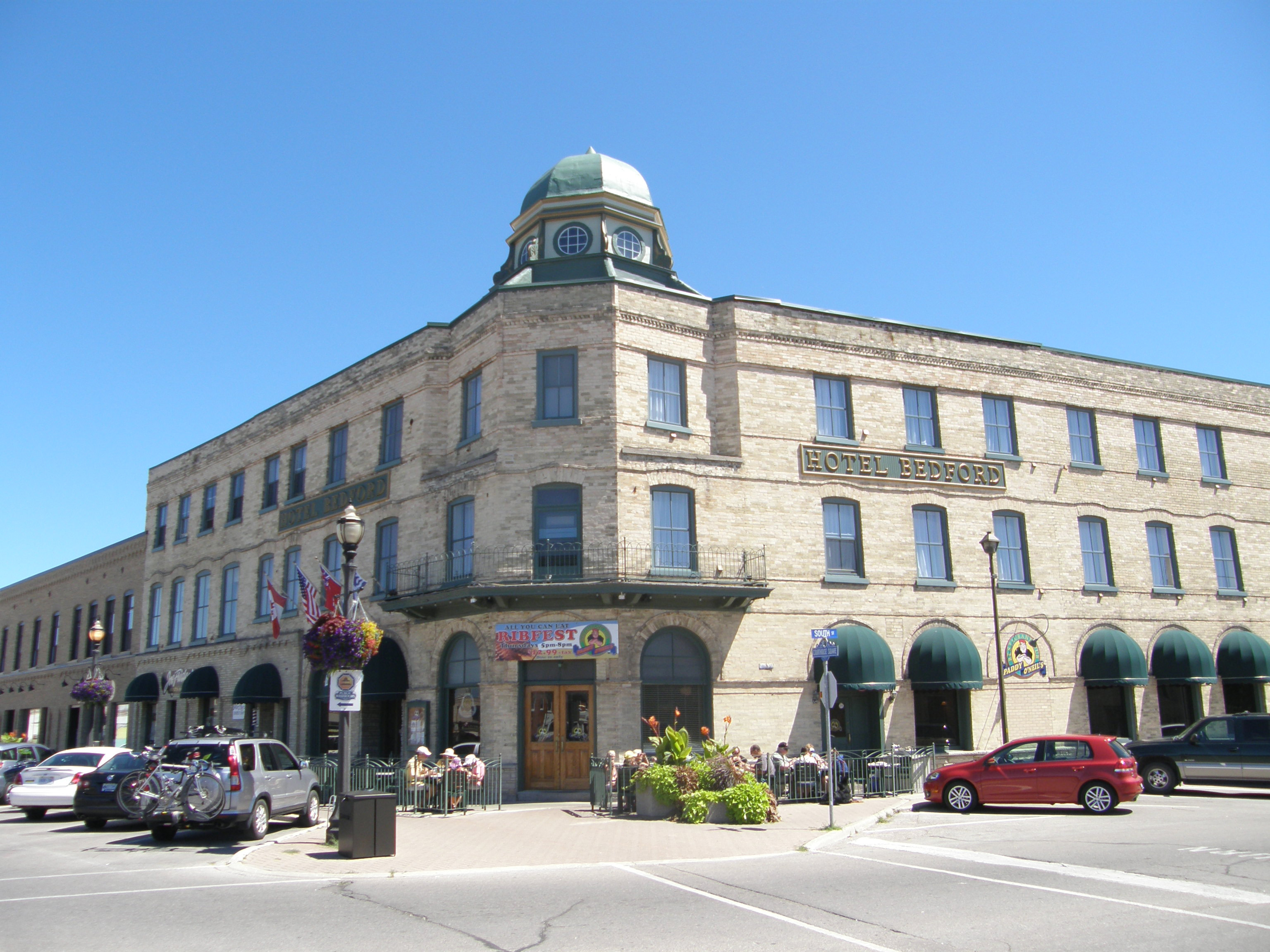
92 The Square – Hotel Bedford – 1896 – three-storey hotel with thirty-five rooms – Romanesque arches on the ground floor and restrained Italianate decorative elements such as the large cupola and projecting balustrade above the entrance.
Huron County Court House – After the tornado with no trees left
Sifto Salt Mine
52 Montreal Street – Goderich Public Library was opened in 1903 as a Carnegie library. It is in the Romanesque Revival style with the large round tower, the round-headed windows, and the irregular roof.
65 Montreal Street – The “Garrow House†was built around 1850 and was the residence of James Thompson Garrow who later became Supreme Court Judge and local Judge of the Canadian Exchequer Court. It is in the Italianate style with unusual bracketing, a two-storey veranda, large front windows and two end chimneys, a central Palladian window and decorative stone lintels and keystones.
57 West Street – Port of Goderich Municipal Offices in 2007 – It was built in 1890 of stone in the Romanesque style with massive gables. The building was designed by Thomas Fuller, one of Canada’s leading early architects. The rusticated stone coursing and wall capping add to its monumental appearance.
20 Wellington Street South – The “Strachan House†was built by Adam McVicar, builder of the lighthouse, in 1880. A schooner brought 40,000 bricks to Goderich to construct this mansion for Donald Strachan, a prominent businessman. The Second Empire house features a mansard roof of patterned slate, and a tower crowned with iron cresting, and intricately molded window headings.
1 Beach Street – Canadian Pacific Railway station – The station is built of red brick with limestone foundation. It has a hipped roof over the central portion with a cross-gable and lunette trackside. Restored slate tiles top the conical roof of the round waiting room. The station house was opened for service in 1907. Passenger service ended in 1956, and mixed train service in 1961. One of the last CPR trains stopped on the bridge on August 3, 1988 and blew its whistle for a final time.
5 Cobourg Street (the MacDonald House) was the office of the Bank of Upper Canada from 1859-63 and the home of its manager “Stout Macâ€. It was built in 1858 in the Georgian style with balanced façade; transom and sidelights are around the front entrance
85 Essex Street – “The Judges House†is a white brick High Victorian structure with a Gothic Revival flavor with Tudor Revival or Italianate features built in 1877. It derives its elegance from the symmetry of the three-bay façade. The symmetry is further emphasized by the square bay windows on the first floor as well as the central porch under the central dormer. The delicacy of the wooden barge boards and rails over the bay windows add pleasing touches.
135 Essex Street Рc. 1880 Рlakefront cottage in the Picturesque style Рdistinguishing features include the prominent pyramidal roof, which extends over the main fa̤ade verandah and the glazed sun-chamfered wood columns with decorative brackets.
56 Wellesley Street – Gothic Revival, bay window
82 Wellesley Street – erected in 1888, the Tom House is an Italianate structure built for Mr. John Elgin Tom, a public school inspector for West Huron. The most notable features include iron cresting on the roof peak, decorative brackets and fascia boards under the soffits, decorative fretwork around the center gable, metal roofing tiles, brick chimneys, and the square bay on the west side.
203 Lighthouse Street – The Wellesley or Wilson House was built by William Bennett Rich, a former Grenadier Guard who later served on Town Council. The house was built around 1845 and combines Georgian and Neo-classical influences. Mr. Rich had several outstanding homes built in town as wedding presents for his many daughters. It has a hipped roof, shutters on the windows, and a verandah with open railing
126 North Street, the Baechler House, was built in 1882 for druggist James Wilson, but it was in the Baechler family for 60 years. The tower with curved glass windows and the deep verandah wrapping around the building are typical of the Queen Anne style.
53 North Street was built in the Queen Anne style by George Acheson about 1905. Features include the pleasing proportions of the three-storey tower, frontispiece with gable, deep veranda with Doric pillars, and pediment with decorated tympanum
38 St. Vincent Street, the Johnson House, was built in 1863 for Hugh Johnston who married one of the six daughters of William Bennett Rich. It is vernacular Georgian in its massing and proportions but with Regency influences in the French doors, a Classical verandah and windows, and Italianate cornice brackets.
Widow’s walk on rooftop, 2½-storey frontispiece with semi-circular window in gable, one-storey wing with flat roof
92 St. George’s Crescent, McDermott’s Castle, begun in 1862 in an attempt to replicate the owner’s Irish castle, sat empty until 1904. A new owner added the third floor and finished the roof and tower which contained an elevator run by water from a cistern on its roof. Tower to the right has corbels on the corners and a parapet.
103 St. George’s Crescent, the Donnelly House, was built about 1880 for Horace Horton, a local businessman, mayor and MP. Second Empire style has both convex and concave mansard roof lines with round-topped dormers, elaborate keystones, a 3½-storey tower, corner quoins, and a second floor semi-circular balcony.
150 St. George’s Crescent was built for Joseph Williams, importer of fine timber which was much used in this home. Italianate – hipped roof, chipped gable with verge board trim, second floor balconies above entrance and side bay windows, corner quoins, prominent keystones above windows
28 Nelson Street West – built around 1870 – The bracketed trim beneath the eaves and the disposition and shape of the windows are Italianate in style. It has a hipped roof, frontispiece, keystones and drip molds.
80 Hamilton Street – “Thyme on 21†is a restaurant in a Victorian heritage house built in the late 1870s with iron cresting on the porch and roof peak; scroll work on the bay window and the porch is unique to this community.
#181 – Italianate – hipped roof, 2½-storey tower-like bay with verge board trim on gable with diamond-shaped window; paired cornice brackets, fretwork, decorative veranda entrance with stenciling
Erin is a picturesque town in Wellington County about eighty kilometers northwest of Toronto. Erin is an amalgamated town, composed of the former Villages of Erin and Hillsburgh, and the hamlets of Ballinafad, Brisbane, Cedar Valley, Crewson’s Corners, Ospringe, and Orton, as well as the former Township of Erin. There are rolling countryside, meandering rivers, small settlement areas and quaint village settings.
The village of Erin is located on the west branch of the Credit River which is known for its pure cold water and trout and salmon fishing as it flows towards Lake Ontario. It joined the east branch of the Credit River at “Forks of the Credit”, with the east branch finding its source above Orangeville.
The first sawmill was built by the Trout family in 1826, at the lower dam at Erin. They opened a small store, and made potash, used in soap-making. The sawmill was later taken over by William Chisholm, from whom Daniel McMillan rented the mill. Daniel McMillan found that the mill cut very slowly, and decided to buy it, and rebuild it to suit himself. Daniel borrowed money to make the first payment, and through hard work and good planning, he was able to meet his obligations.
Daniel McMillan was the man responsible for the growth of the village, assisted by his brothers, Hugh and Charles. Daniel McMillan, 1811-1849, was the oldest son of Donald McMillan and his wife, Catharine Miller, who came with their family from Scotland in 1822. They settled on lot 19, concession 9, Erin Township, and he also took up lots 14 to 17, on both sides of the 9th line. The land that became the site of Erin Village consisted of lots 14, 15 and 16.
In 1834, Daniel McMillan erected a grist mill at the south-west end of the sawmill and the same power was used for both. The same year, Daniel built the first house in the village, east of the sawmill. In 1835, he brought his bride, Mary McLaughlin, daughter of Daniel McLaughlin of Caledon. After clearing the river flats on lots 14 and 15, the present Upper Dam was built, and here the second sawmill was built in 1838. It had new machinery and was a faster cutting mill.
Daniel McMillan built the oatmeal mill on the other side of the street, opposite the first sawmill, using water power supplied by the hand-dug race from the Lower Dam. This oatmeal mill did a good business, and was still in good shape in 1922, when it was being used as a planing mill by Mundells.
In 1838, McMillan built a grist mill at the Upper Dam. It had a large trade for about ten years. It had three run of stones, and they also made oatmeal. It did good work with dry wheat, but not if the grain was damp. This building became a woolen mill.
In 1845, Daniel McMillan had a large stone house built. It was the family residence for twenty years. Then it was sold to William Chisholm, and it became the Globe Hotel, until it was destroyed by fire in January 1945.
In 1847, Daniel McMillan decided to build a more up-to-date grist mill, or flouring mill, that would meet the needs of the fast-growing community.
Erin Village expanded rapidly through the 1840s. Lumbermen and millers enjoyed favorable tariff with the United States when wheat was brought from the States to Canada where it was processed, then shipped to Britain. This increased demand for flour was the reason Daniel McMillan built his new grist mill, which he planned to have in operation by Christmas, 1849.
A surveyor was engaged to choose the best location, the site where Bell’s Mill stood in 1922. Stone masons were brought from the Old Country; the race known as the “Big Ditch”, brought water from the Upper Dam. The building was to be six stories high. There were 200 men at the raising, and it took three days to erect. Everything went according to schedule. The intricate machinery was put into place. When Daniel McMillan went to Toronto for the mill stones, he was accompanied by his brother, Hugh, and his best friend, John Rott (Root), in whose Conestogo wagon the mill stones were brought to Erin.
On December 14th, he got a sliver in one of his fingers, but no attention was paid to it at the time. However, blood-poisoning developed, and he died in great agony three days later, on December 17, 1849, at the early age of 38 years. The Mill was finished on December 22nd. This mill became the Co-Op Building.
Daniel McMillan was a man of tremendous energy and planning ability; and in the short period of eighteen years in Erin Township, he achieved more than most men do in a lifetime. He was a leader, and had established his village on a firm footing. But without its leader, the village had lost its sense of direction.
Alexander McLaughlin, the great Canadian Poet, and life-long friend and admirer of Daniel McMillan, wrote a long poem about him, expressing very effectively, his great loss to the Erin community. Title of the poem: “A Backwood Hero”, is an In Memoriam. This is the first of ten verses.
Where yonder ancient willow weeps, The father of the village sleeps; Tho’ but of humble birth, As rare a specimen as he, Of Nature’s true nobility, As ever trod the earth, The busy head and hands are still; Quenched the unconquerable will Which fought and triumphed here; And tho’ he’s all unknown to fame, Yet grateful hearts still bless his name, And hold his memory dear.
Reference is made to his planning and assistance in building roads, schools, churches, mills, a store, forge, vat, and kiln. He seemed to be doctor, lawyer, judge, surveyor, and was never too busy to lend a helping hand.
In 1838, Daniel had encouraged William Cornock to locate in the village. Cornock built a distillery that continued in operation until 1860. Mr. Cornock also operated the first dry goods store, and secured a Post Office for the village. A lime quarry was opened by James Shingler. S.L. Shotter opened the first general store on the corner that was occupied by the Post Office in 1922.
North of Shotter’s store, Daniel McMillan erected a building known as the cooperage, where he and his brothers worked on wet or stormy days. They made barrels for flour, tubs, churns, wooden pails, wooden pumps, etc., which were much in demand by the early settlers. They also made coffins.
In 1839, Erin Post Office was opened under the name of “Macmillan’s Mills”. In 1851, the name was changed to “Erinsville”. The village had 300 people, two grist mills, two oatmeal mills, a distillery, a carding and fulling mill, a tannery, and a church with free use to all denominations. Agricultural prosperity and abundant water power stimulated the community’s growth as an important regional center for milling and the manufacture of wood products. In 1879 a branch of the Credit Valley Railway was completed through Erin to Toronto.
Erin is primarily a rural community but, while farming is still an important activity in the town, most of its population works in the nearby cities of Brampton, Mississauga, Guelph, and Toronto. Wander the beautiful downtown, enjoy the shops, and find unique treasures that are great for gifts. Erin boasts an eclectic array of shopping with everything from housewares and home decor, to clothing and toys. Country living meets boutique shopping in this beautiful village.
156 Main Street – The Busholme Inn at the corner of Main and Church Streets was the home of J.P. Bush and family. It was built circa 1886 by Dr. McNaughton, as a hospital, but was never used for this purpose. In 1893, Dr. Martin owned the large house, then Dr. J. Hamilton, and several other doctors. In 1926, Dr. Reynolds sold to J.P. Bush and it became a hotel. Mrs. McKenzie purchased it in 1930, and in 1967, it was owned by Matt Fullerton of Brampton and T.B. Cooper of Toronto. Now it is the Jolly Rogers’ Restaurant. It is in the Italianate style with a hipped roof, dormer, two-story frontispiece, and corner quoins. The arched lintels with a central keystone were made with sandstone from the Credit Forks quarry.The Erin Pioneer and Continuation School – c. 1854 – was the second school opened in the Township, and became S.S. #2. First school for Erin Village was built on lot 18, concession 9, on the lot that later became McMillan’s Burying Ground. This school was also used as a church for some years. Since the settlement developed to the south, a small frame school was erected in a more central location, on lot 15, concession 9, on the Conboy property. Another school was built on the site of the Baptist Church, later the property of Mrs. Fred Bingham.
In 1854, the stone school was built on the David Mundell property. At first it was one room, later two rooms. The first teacher was William Firstbrook. Three-quarters of an acre was purchased from the estate of D. McMillan, at the rear of the Union Church (now Presbyterian) for a house and garden to be used by the teacher.
In 1924, the new Continuation School was opened and in 1926, it was up-graded, offering all grades from 9-12. Until 1951, Erin had a Continuation School, housed upstairs in the Erin Union Public School on Main Street. In 1944, it was considered a small school, and the Department of Education urged such small schools to close. Erin Village fought against this, circulated petitions and sent delegations to the Department. The community was successful, and established Erin District Board.
In 1951, the name was changed from Erin Continuation School, to Erin District High School, and immediately they began to look for a separate location for a new school. In February 1954, seven acres were purchased on Daniel Street, and a four-room building was opened for the 1955-56 term. Four rooms were added in 1958. Another four classrooms were added in 1963, along with offices, foyer, and gymnasium/auditorium.
In 1974, Erin High School was again in danger of being closed, but finally the new addition made space for Industrial Arts, Family Studies, Music, Art, a Resource Centre, more offices, a gym and cafeteria, biology lab, and an “Open Concept” on Second floor.
In 1975, the Second Floor was changed to six classrooms; and since 1975, several Portables have been added. The County Board system was introduced in 1969.
For the 1955-56 school year, there were 115 students, with three teachers and a Principal. In 1974, there were 729 students with 40 teachers. In the 1995-96 term, there were 653 students, the Principal, Vice-Principal and 48 teachers.
The 40th Anniversary of Erin District High School was celebrated on May 10-11, 1966, with a School Reunion.
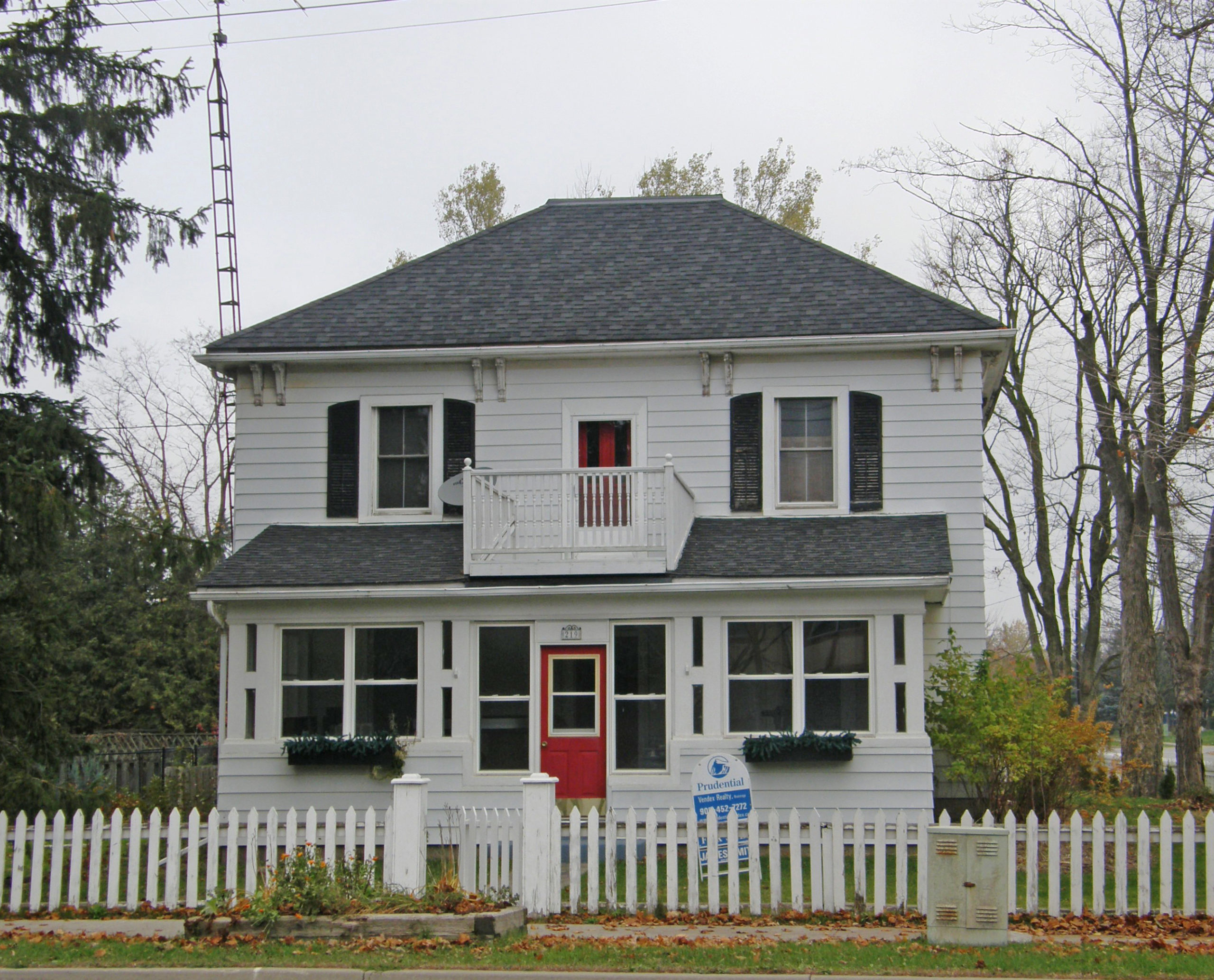
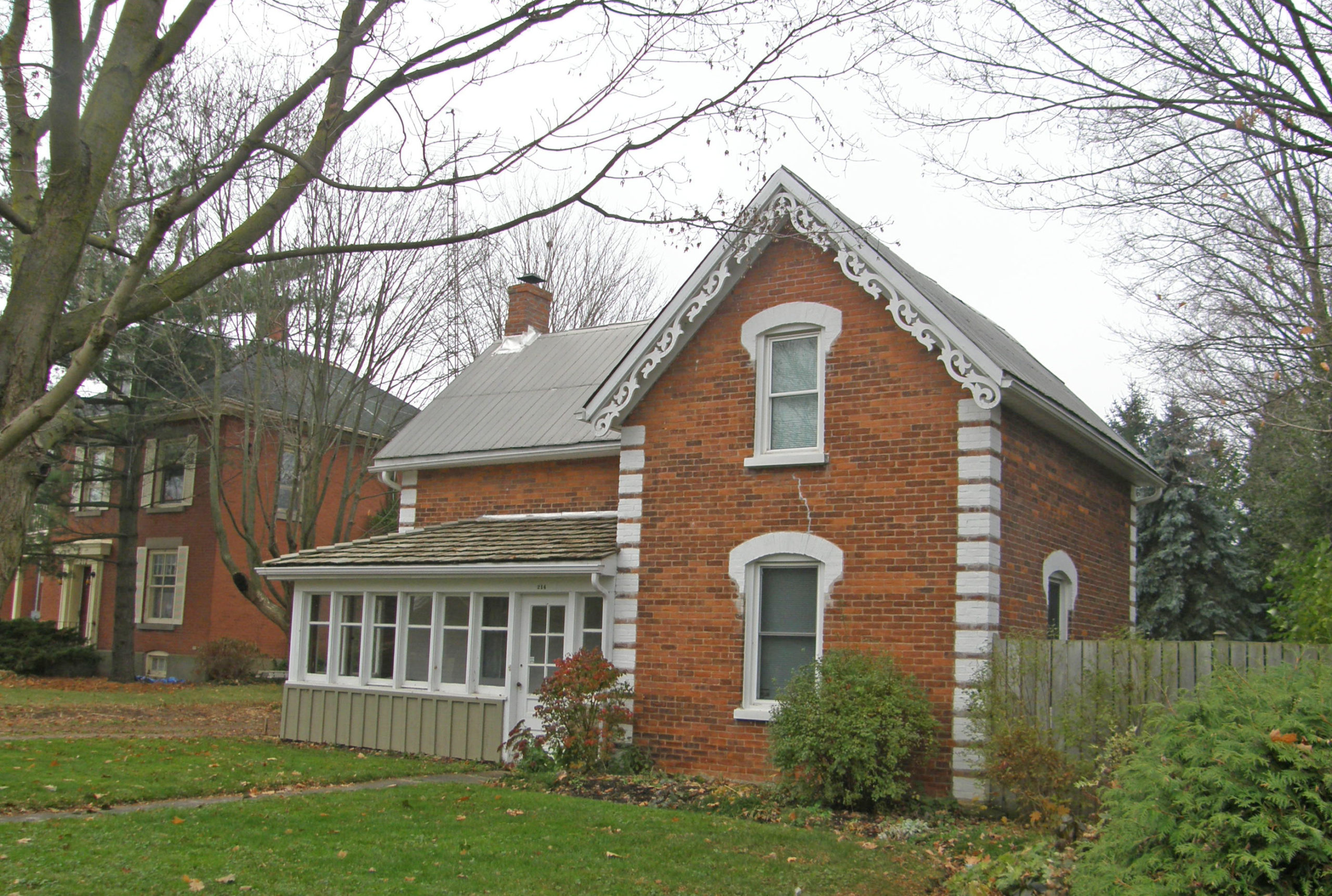
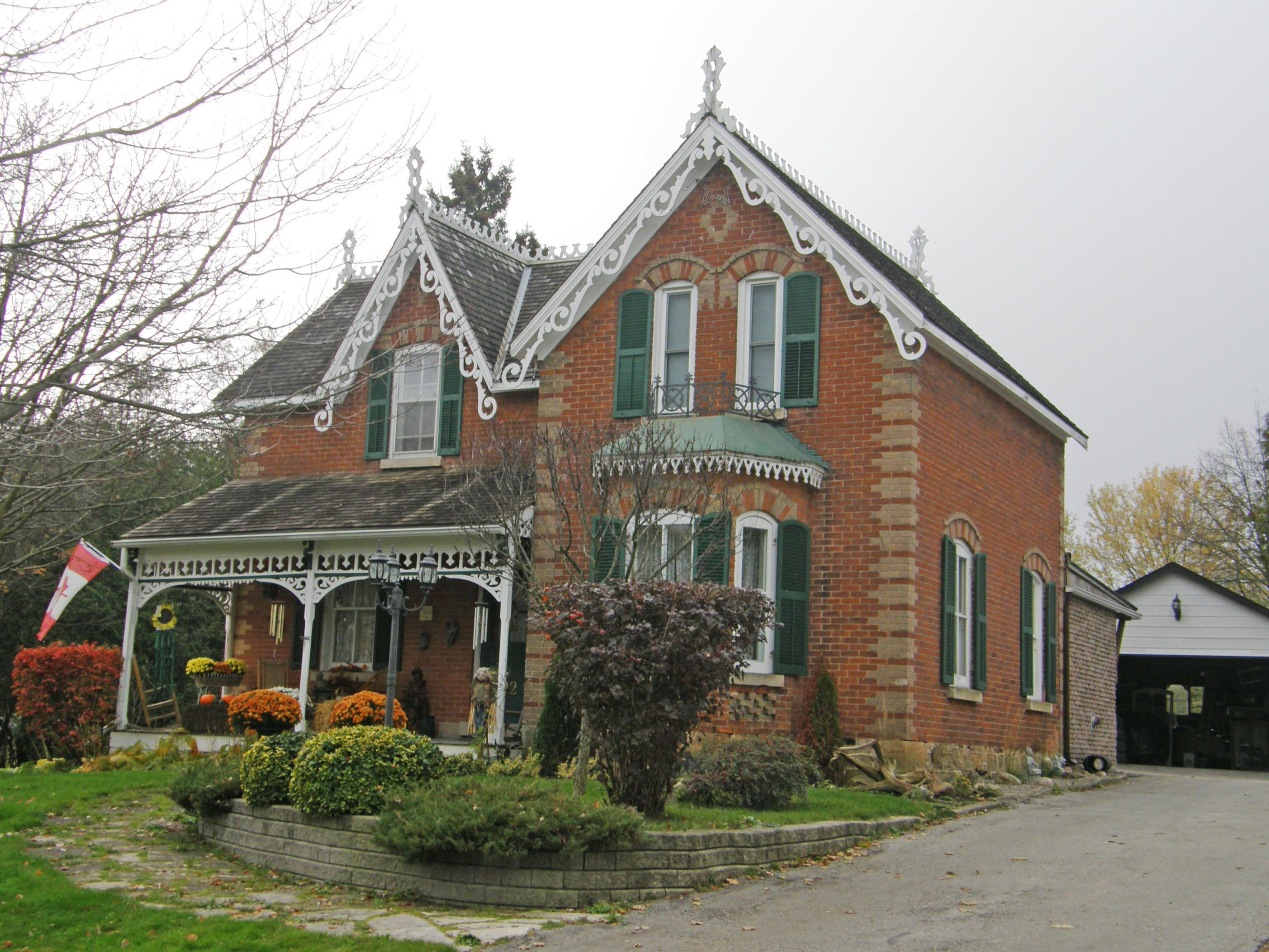
219 Main Street – hipped roof, balcony above enclosed porch214 Main Street – Victorian – gingerbread trim, contrasting white corner quoins213 Main Street – Italianate – built A.D. 1891 – hipped roof, paired cornice brackets, iron cresting above bay window, dichromatic brickwork202 Main Street – Gothic Revival – late 1800s – verge board trim and finials on gables, bay window, corner quoins, dichromatic brickworkSpring Street – Italianate style – paired cornice brackets, second floor balcony with bric-a-brac detailing above the capitals on the support pillars163 Main Street – Italianate – two-story frontispiece with barge board trim on gable; corner quoins, stained glass transom windows on doors and some windows3 Union Street – Daniel McMillan sold 100 acres of land to his brother Charles who built this early brick house in 1856. Devonshire House and Spa – dichromatic brickwork
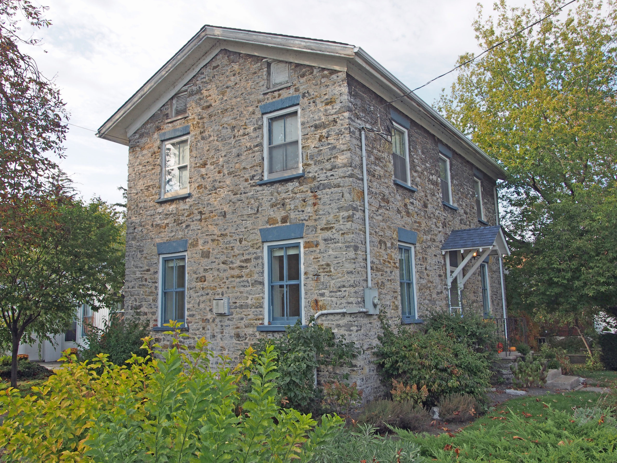
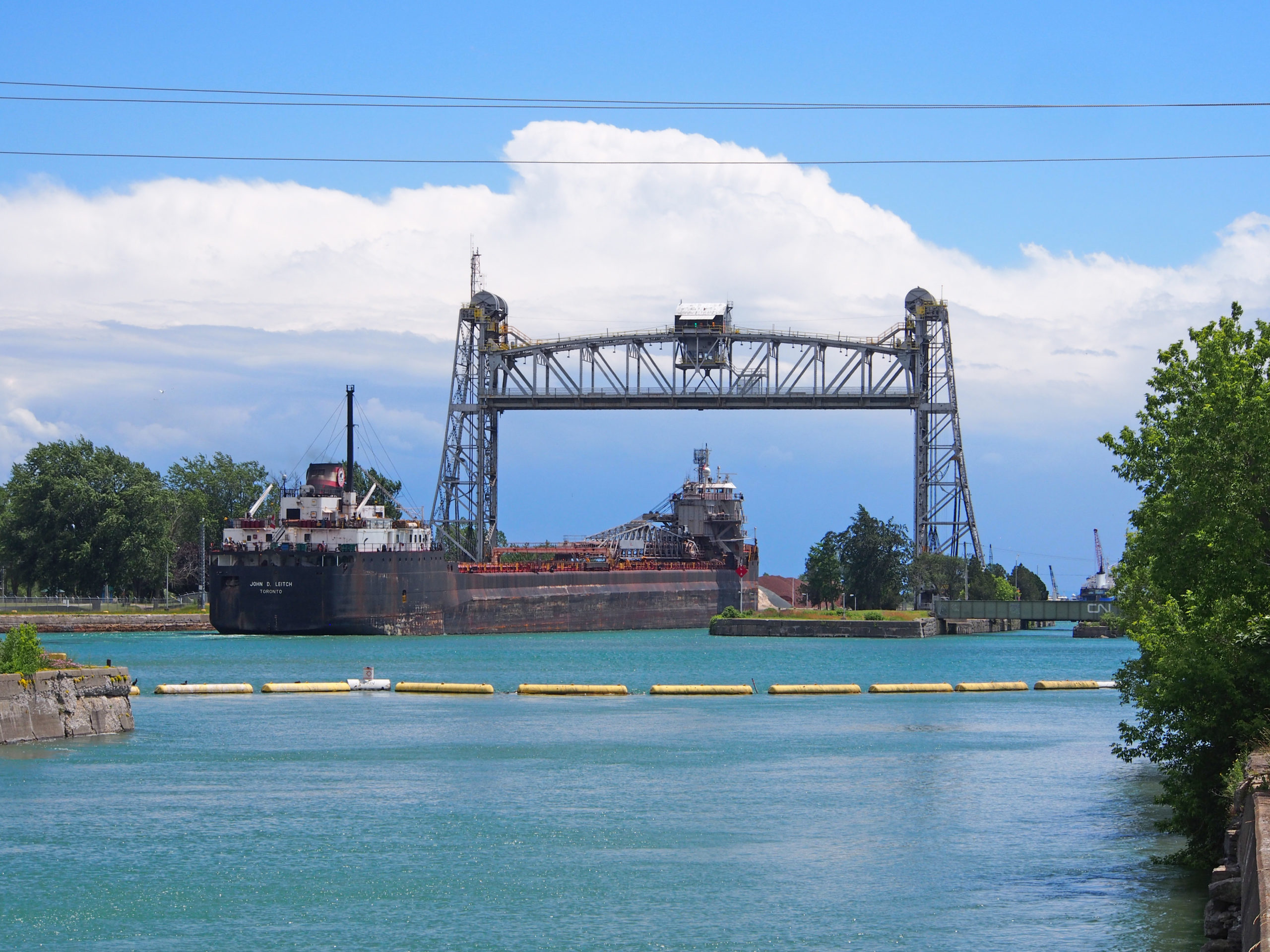
Port Colborne is a city on Lake Erie, at the southern end of the Welland Canal. The original settlement, known as Gravelly Bay after the shallow, bedrock-floored bay upon which it sits, dates from 1832 and was renamed after Sir John Colborne, a British war hero and the Lieutenant Governor of Upper Canada at the time of the opening of the southern terminus of the First Welland Canal in 1833 when it was extended to reach Lake Erie.
Port Colborne was one of the hardest hit communities during the blizzard of 1977. Thousands of people were stranded when the city was paralyzed during the storm.
Maritime commerce, including supplying goods to the camps for the laborers who worked on the first canal, ship repair and the provisioning trade, was, and still is, an important part of Port Colborne’s economy. Port Colborne was a heavily industrial city throughout most of the early twentieth century. A grain elevator, two modern flour mills, a Vale nickel refinery, a cement plant and a blast furnace were major employers. Several of these operations have closed over the past thirty years, while others employ a lot less residents due to modernization and cutbacks.
Port Colborne has been successful attracting agro-business operations which process corn into products such as sweeteners and citric acid. The economy has gradually shifted towards tourism and recreation, taking advantage of the scenic beauty of the lake shore.
The Port Colborne Historical and Marine Museum, located near the center of town, is a resource for local history and archival research. In addition to a collection of historic buildings and artifacts, it opened up the “Marie Semley Research Wing” to foster research into local history; it was named to commemorate the long-standing efforts of a local resident who devoted hours to the museum.
380 King Street – The only example of Romanesque Revival in Port Colborne, this home was built about 1907 for Thomas Euphronius Reeb. The Romanesque is shown in its dark red brick and heavy cut stone window sills and lintels. The Queen Anne influence is evident in the octagonal tower with lard “band shell†verandah, wide round-arched first floor window with etched leaded glass and a line of terracotta tiles with egg and dart motif under the eaves. – Port Colborne Book 1
296 Fielden Avenue – This magnificent stone and brick Victorian building was erected circa 1860 for Levi Cornwall. Lewis Carter had it redone in its present Italianate/Second Empire form about 1879 with ornately bracketed eaves, multiple bays, mansard roofs, an impressive three-storey tower with four double-hung “Port Colborne†windows, and round headed or elliptical shaped windows, some paired or tripled. – Port Colborne Book 1
346 Catharine Street – The former St. James’ Anglican Church Rectory (until 1957) was built in two stages with the eastern portion built for Lewis Carter c. 1875 and the western part was added when the house was purchased as a rectory in 1897. Note the two-story bay window in the west wing, and round-headed windows capped with brick voussoirs which indicate the Italianate style. – Port Colborne Book 144 King Street – 1835 – one of only a few stone structures in Port Colborne – The walls, made of limestone taken from the Welland Canal, are more than half a meter thick. The Georgian style of architecture is evident in the balanced three-bay-facade and centered doorway. – Port Colborne Book 1322 King Street – Ingleside – It was built in 1867 for Charles H. Carter and occupied by the Carter family for 118 years, including Port Colborne’s first mayor, Dewitt Carter. The two-story structure has projecting eaves supported by paired cornice brackets and corner quoins in dichromatic brick characteristic of Italianate architecture. Its rectangular plan with projecting frontispiece and hipped roof indicate it is a version of a house plan popularized by the magazine “The Canada Farmer†in 1865. The grounds are surrounded by a locally produced cast iron fence. – Port Colborne Book 1326 Catharine Street – The Harvie House built in 1900, it is a typical Queen Anne Revival style home and has a wraparound verandah with offset circular tower, two types of siding and a pyramidal roof. The house takes its name from the Harvie family who owned it from 1911 to 1951. – Port Colborne Book 114 Catharine Street – Wildwood – c. 1875 – This house displays an eclectic mix of late Victorian styles with a mix of bays, an oriel window and turret on its north side in contrast to the restrained Greek Revival style of the east and south facades. It began as a small two-story brick house built by William Arnott on the lake shore in 1876. In 1886 it was purchased as a summer and retirement home by Carolina residents, Joseph and Alice Dickenson, who enlarged it to its current form. The cast metal lions were imported from the Carolinas by the Dickensons. The New England influence is evident in the architectural styles. – Port Colborne Book 1232 Clarence Street – Built by lawyer Louis Kinnear in 1904, it was the home of his daughter Judge Helen Kinnear from 1904-1943, the year she became the first federally appointed woman judge in Canada and the Commonwealth. Helen Kinnear was also the first woman in the Commonwealth to be granted in 1934, “King’s Council,†a distinction given to noteworthy lawyers. She was also the first woman lawyer to appear before the Supreme Court of Canada. The house exhibits a combination of Edwardian and Victorian architectural styles. – Port Colborne Book 1155 Main Street West – The Century House – c. 1889 – The early-twentieth century commercial building was constructed in a vernacular version of the Classical Revival style popular in rural Ontario. It has a flat facade with symmetrical window arrangement and a gable end. It is characteristic of small town store construction of mid-nineteenth century combining a first-floor shop with residence above; it incorporates innovations of later-nineteenth century commercial buildings with larger panes of glass in the shop windows and a recessed store entrance. It is now “Deli on Mainâ€. – Port Colborne Book 2145 Main Street West – The Augustine House was built by Elias Augustine circa 1860, it displays a mixture of mid-nineteenth century detail. The gable front arrangement and symmetrical placement of doors and windows are from the Greek Revival style. The semi-elliptical shape of the openings is an Italianate detail. Note the detailed woodwork of the verandah with its small pediment framing the double-leaved front door. Mr. Augustine was an owner of the carriage manufacturing firm of Augustine and Kilmer. Some production for the business was done in a blacksmith shop formerly located behind the house. – Port Colborne Book 2Lift Bridge with ship214 Steele Street – Steele Street Public School – The symmetrical red brick facade trimmed with yellow terracotta tile with an impressive central pediment show the dignified Edwardian Classical style, the style that was at the height of its popularity in 1915 when the school was built. The school and the street were named for the Steele family who were early settlers of Humberstone Township. – Port Colborne Book 2
Belleville, Ontario – Part 2 – My Top 14 Picks
Belleville is a city located at the mouth of the Moira River on the Bay of Quinte in southeastern Ontario. It was the site of a Mississaugas’ village in the eighteenth century. It was settled by United Empire Loyalists beginning in 1784. It was named Belleville in honor of Lady Arabella Gore in 1816, after a visit to the settlement by Sir Francis Gore and his wife.
It is known as the “friendly city†because it offers big city amenities along with small town friendliness, and a pleasing mixture of the historic and modern.
Belleville became an important railway junction with the completion of the Grand Trunk Railway in 1855. In 1858 the iron bridge over the Moira River at Bridge Street was constructed. Belleville’s beautiful High Victorian Gothic city hall was built in 1872 to house the public market and administrative offices.
Due to its location near Lake Ontario, its climate is moderated by cooling hot summer days and warming cold days during the fall and winter.
Procter & Gamble, Kellogg’s, Redpath, and Sears are corporations operating in Belleville. There are many other manufacturing sector companies which operate within the City of Belleville, including Sprague Foods, Sigma Stretch Film Canada, Reid’s Dairy, and Parmalat Canada – Black Diamond Cheese Division, to name a few.
Belleville has an excellent yacht harbor, which is a picturesque stopping point for Great Lakes sailors and a favorite launch for sports fishing enthusiasts after walleye, pike and bass. Beautiful music chimes can be heard all year long from the City Hall clock tower, overlooking the new civic square and Farmers Market. Walking, biking and rollerblading can be enjoyed on the Bayshore and Riverfront Trails.
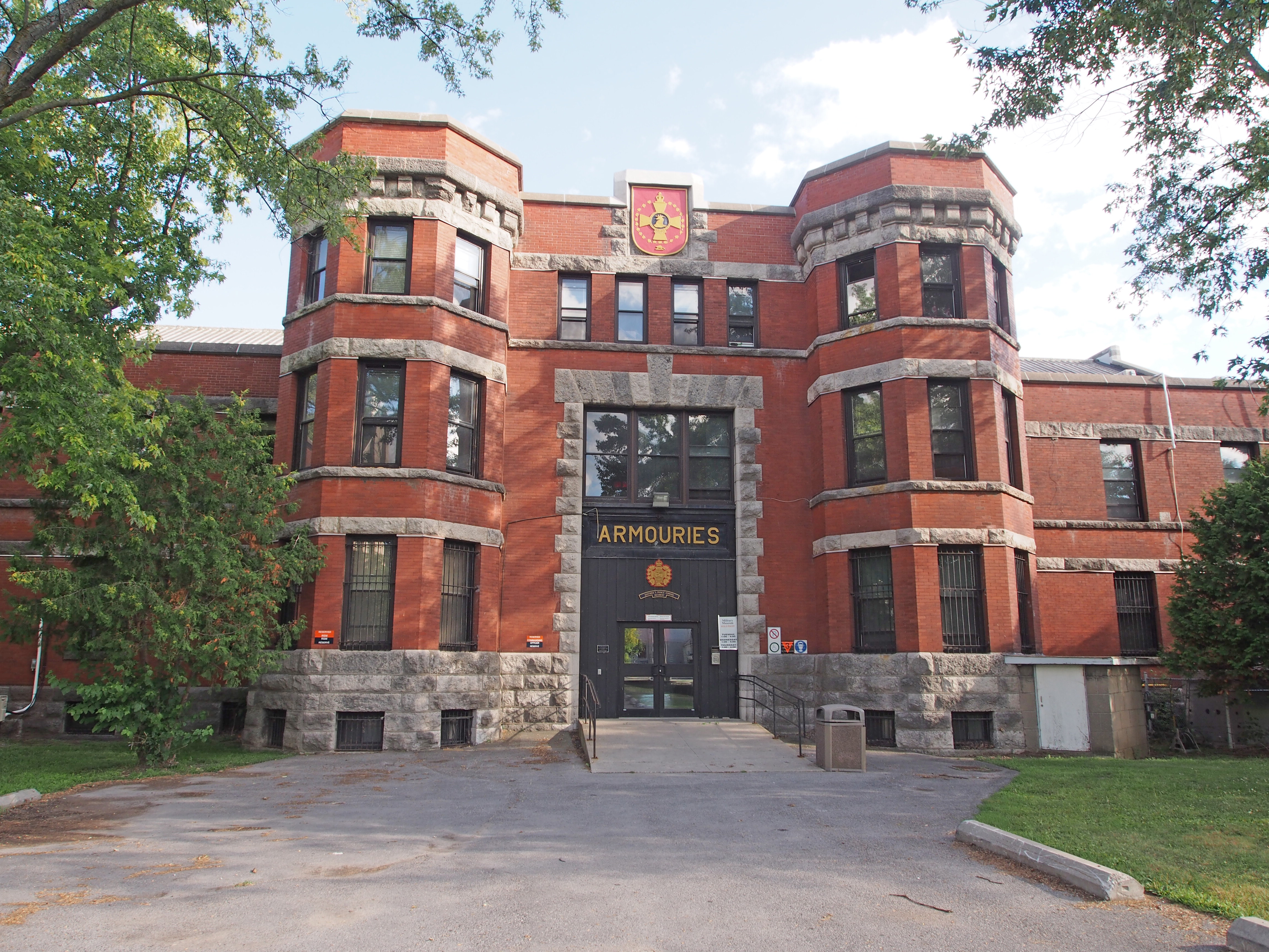
Bridge Street East – Belleville Armouries – The structure brings to mind a medieval fortress as evidenced in the solid brick construction, stone detailing and the use of three-storey towers flanking the entrance of the administrative block. It has a symmetrically organized façade with rough-cut stone window dressings, narrow vertical window openings, and its medieval detailing such as the string courses, copings and battlements. – Belleville Book 3
105 Bridge Street East – Italianate – hipped roof, 2½-storey bay with cornice return on gable, banding, Corinthian pillars on veranda, pediment – Belleville Book 3
128 Bridge Street East – Queen Anne style – turret, tall decorative chimney, decorative tympanums on the gables, pediment, open railing on the veranda – Belleville Book 3
252 Bridge Street East – hipped roof, 2½-storey frontispiece, dichromatic brickwork, bay window – Belleville Book 3
257 Bridge Street East – The Phillips-Burrows-Faulknor House – Glanmore National Historic Site – Glanmore’s property was originally a block wide and extended to Highway 2 (Dundas Street). Harriet Phillips inherited this property from George Bleecker, her grandfather. Glanmore reflects the tastes of the well-to-do in late nineteenth century Canada. The grand house, built by local architect Thomas Hanley, was built in 1882-1883 for wealthy banker John Philpot Curran Phillips and his wife Harriet Ann Dougall, the daughter of Belleville’s Judge Benjamin Dougall. It is in the Second Empire style with mansard roof with elaborate cornices and brackets, dormer windows, iron cresting, a built-in gutter system, and multi-colored slate. – Belleville Book 3
The North Drawing Room was used by Mr. and Mrs. Phillips for entertaining. Ornate columns divide the North and South areas of the double drawing room. The rooms could also be used as a ballroom when the carpets and furniture were removed. The coffered ceilings feature molded ornamental plaster and hand-painted designs. The decorative ceilings are complemented by the original settees, three-seated chaperone’s chair, and mantle surround. The clutter of decorative objects is typical of late Victorian style.
The 9,000 square foot home cost $7,000 to build in 1883. The impressive suspended walnut staircase cost $62.50. The spelter (a zinc alloy) statue lamps and the hanging vigil lamp are displayed in their original locations.
52 Queen Street – Queen Anne Villa – 2½-storey bay with trim and fretwork on gable; cornice brackets; bay window with iron cresting above, oriel window on side – Belleville Book 3
2 Forin Street – cornice brackets, pediment, transom window above door – Belleville Book 4
38 Forin Street – Gothic – verge board trim and finials on gables, round windows in gables, window voussoirs – Belleville Book 4
Alexander Street – hipped roof with dormer with a gabled roof and verge board trim and two windows; cornice brackets; two-storey bay window – Belleville Book 4
68 North Front Street – Belleville Funeral Home and Chapel – a Victorian mansion – three storey tower; dichromatic corner quoins; Mansard roof with dormers, prominent keystones, drip molds and engaged columns; engaged columns at front entrance with sidelights and transom window – Belleville Book 4
80 Highland Avenue – John R. Bush Funeral Home – Second Empire style – Mansard roof with dormers, cornice brackets, banding – Belleville Book 4
110 Bridge Street West – built in 1867 by Smith Steven, clerk in the Grand Trunk Railway solicitor’s office – excellent example of a family home owner of modest means; has original 6/6 pane windows, window sills, and shutters; acorn brackets extend under the cornice; the front door has narrow sidelights – Belleville Book 4