Hagersville, a community in Haldimand County, is located about 45 kilometers southwest of Hamilton, Ontario, and 15 kilometers southwest of Caledonia.
In 1852, Charles Hager built a frame hotel at the corner of the Plank Road and Indian Line. It was called The Junction Hotel and later The Lawson Hotel after a change in ownership. Hagersville’s first post office was in this hotel. With the construction of the Plank Road, a small village popped up in 1855 when Charles and David Hager bought most of the land in the center of the area. David Almas owned the land on the east side of the road, while John Porter owned the land in the west end. Joseph Seymour suggested the community be called Hagersville to honor the Hager brothers.
The building of the Canada Southern Railroad in 1870, and of the Hamilton and Lake Erie Railway three years later helped to make Hagersville a prosperous village.
Hagersville gained notoriety in 1990 with a huge uncontrolled tire fire which spewed toxic smoke into the atmosphere for seventeen days. The fire actually occurred in Townsend, a neighboring community, but media labeled it as Hagersville due to Townsend’s relatively unknown status in the area.
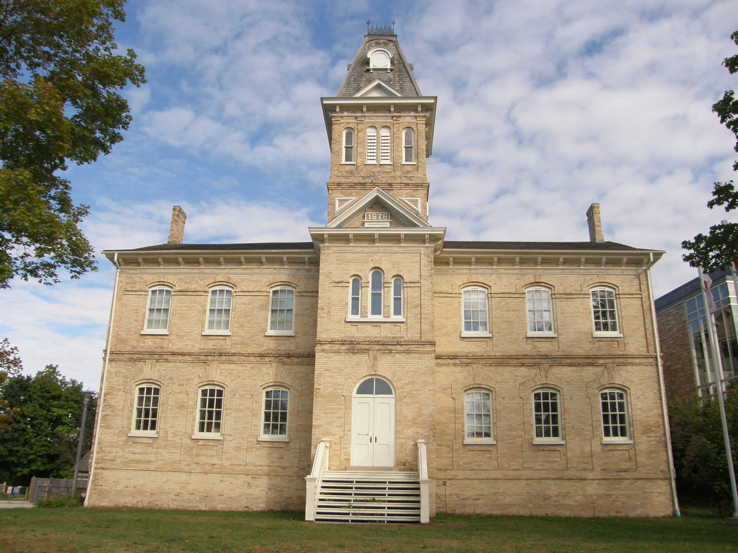
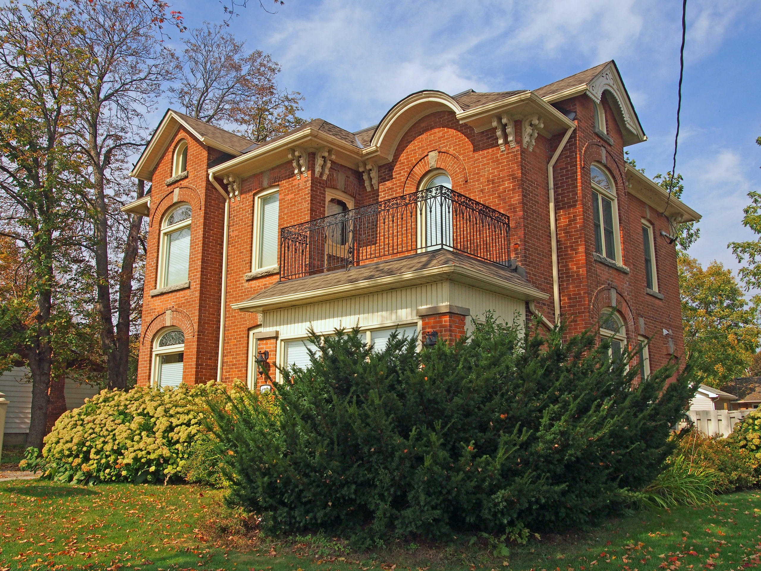
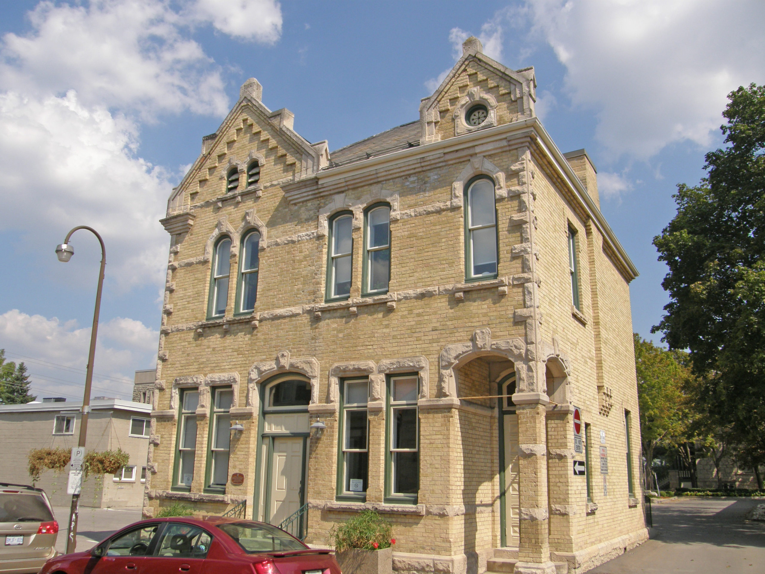
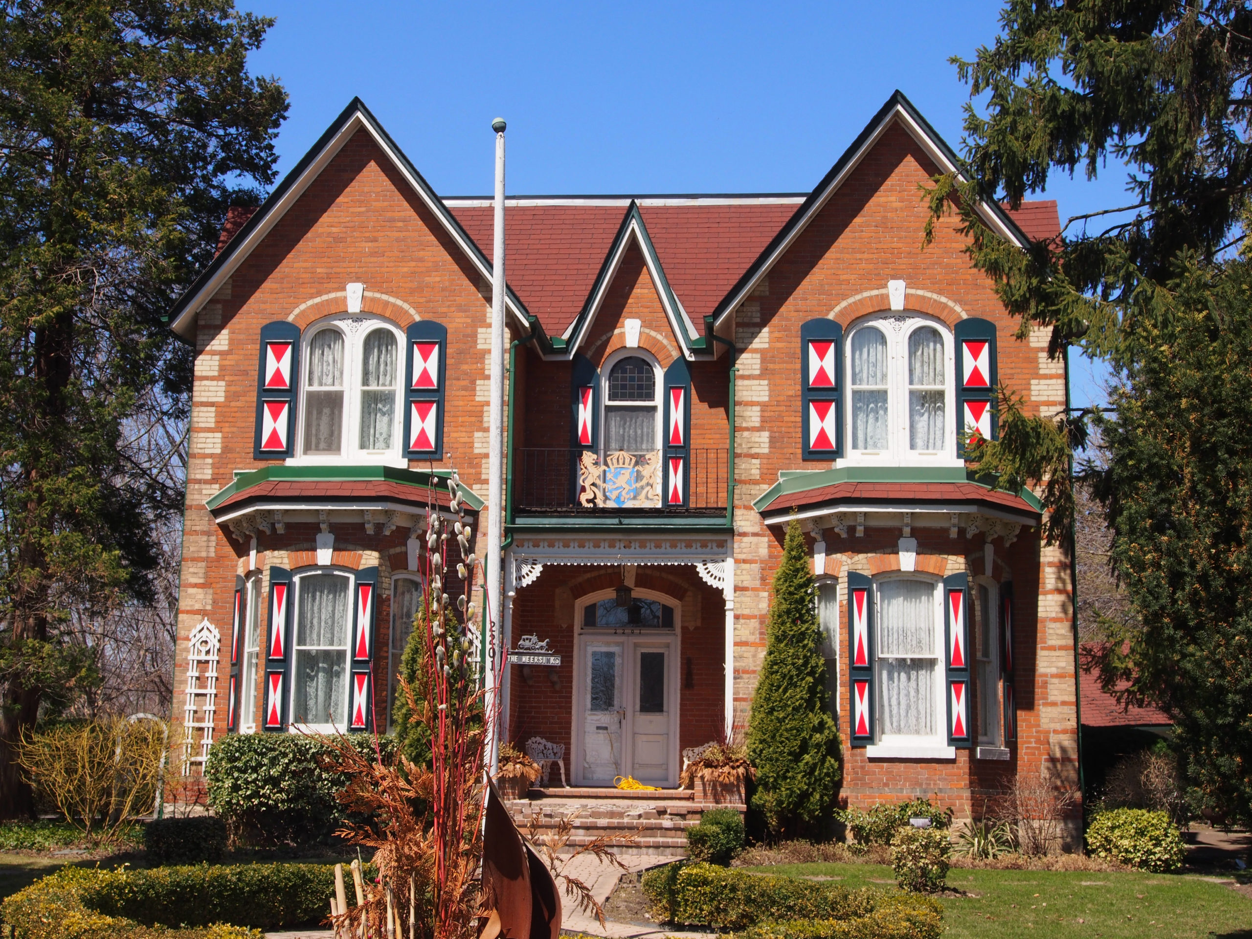
Italianate style, dichromatic brickwork, two-storey bay window
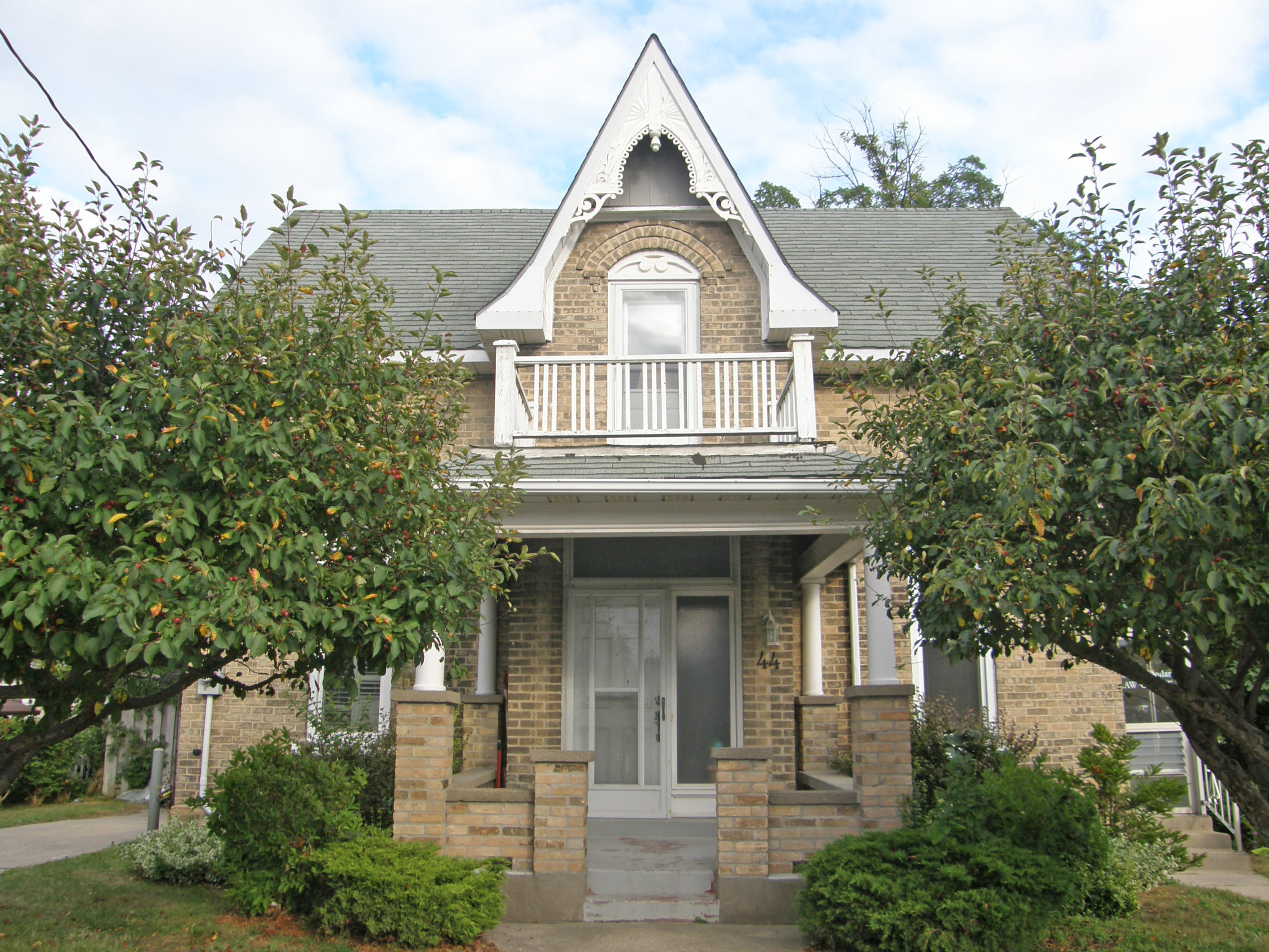
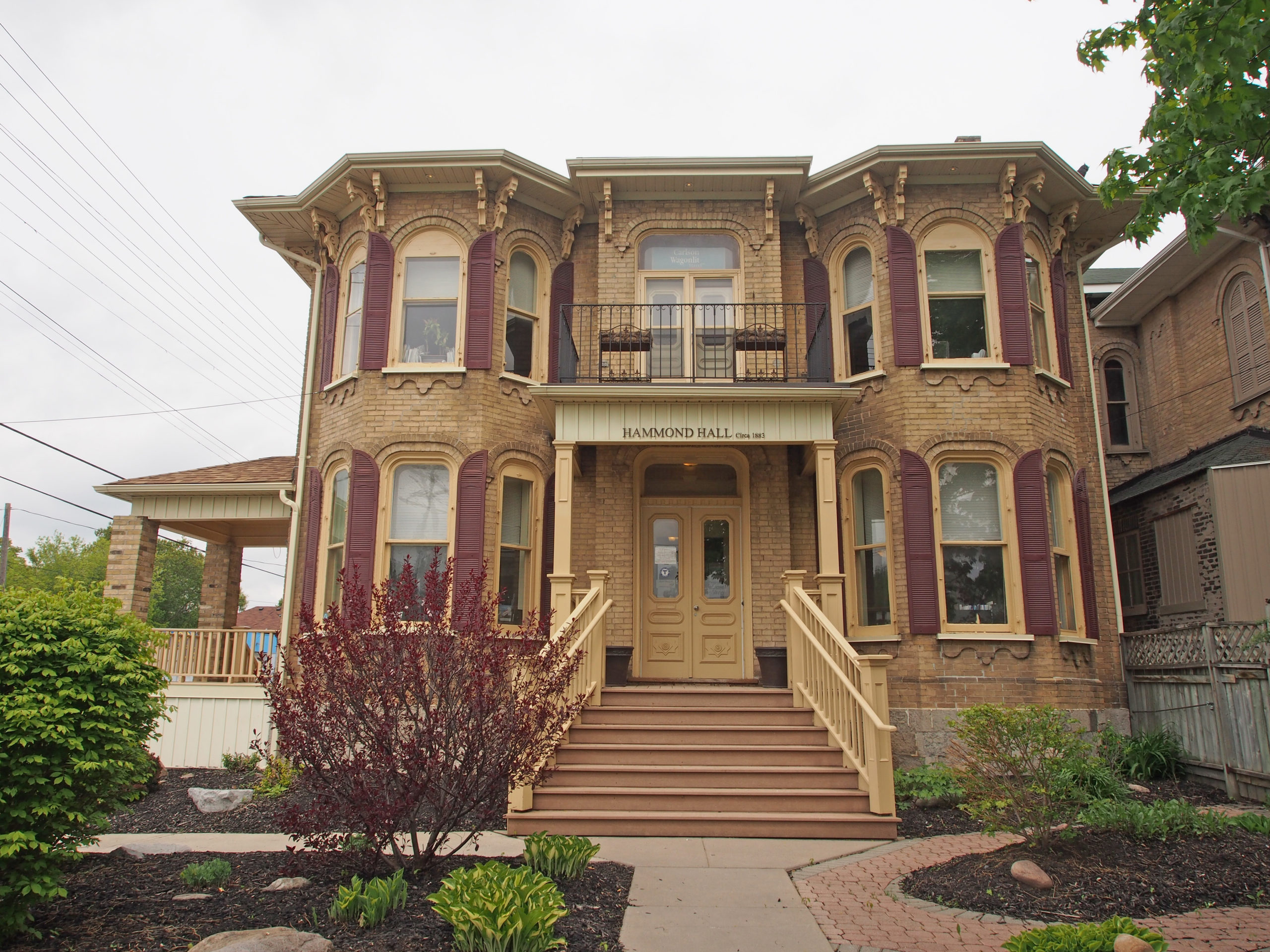
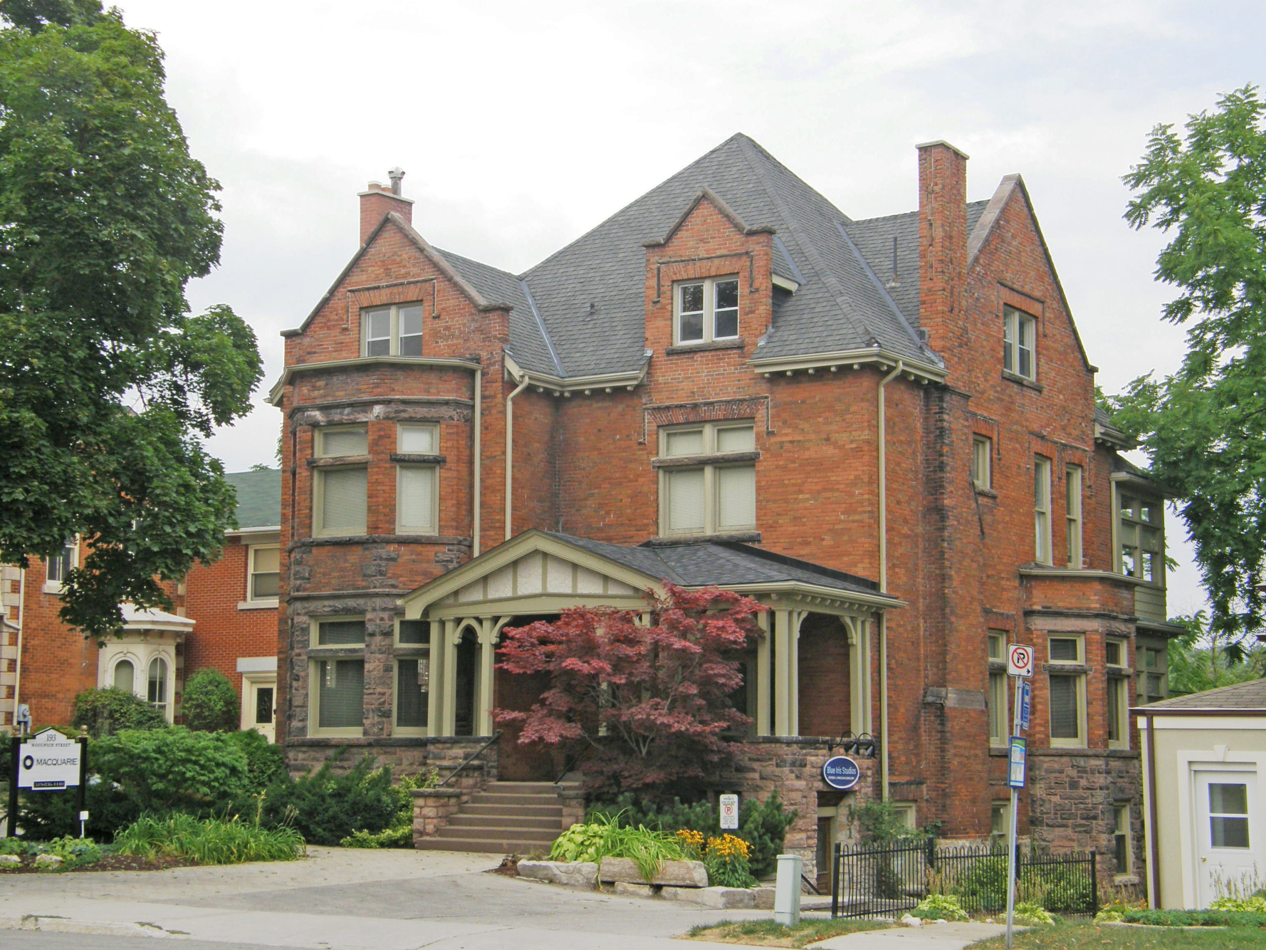
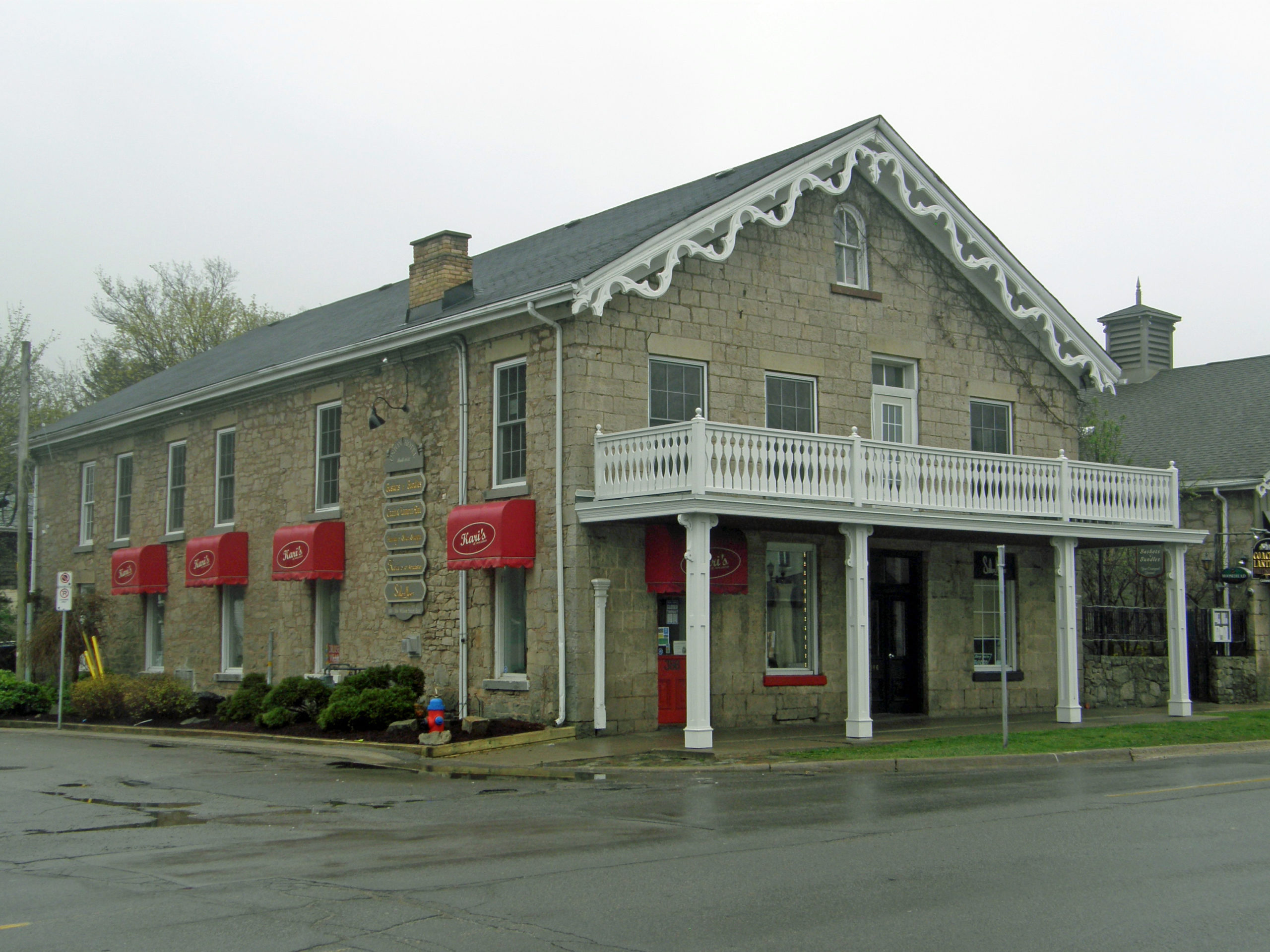
Gothic Revival style – verge board trim, bay window
Jarvis, Ontario – My Top 6 Picks (the photo book also includes pictures in Port Dover)
Jarvis is located near the towns of Simcoe, Cayuga, Port Dover and Hagersville. Jarvis is strategically located at the junction of Highways 3 and 6. Jarvis has some excellent examples of brick architecture. Many of the historic homes were built after 1873. Many of the town’s restaurants and shops are clustered around the intersection of the highways. The majority of the buildings are red brick.
Jarvis Train Station
2145 Main Street – Gothic Revival – verge board trim, bay window with cornice brackets
45 Talbot Street – Second Empire style – mansard roof, dormers in roof, single cornice brackets, cornice return on small gables on window dormers
c. 1847 – Italianate, hipped roof, dichromatic brickwork
2092 Main Street – Italianate – c. 1870 – Italianate style
60 Talbot Street East – Italianate style with frontispiece, triangular pediment, dormers in the attic
Southampton is located on Lake Huron at the mouth of the Saugeen River. It is located south of Sauble Beach and north of Port Elgin.
In the spring of 1848, Captain John Spence, a native of the Orkney Islands in northern Scotland, arrived at the mouth of the Saugeen River after an overland journey on foot from Owen Sound. He was impressed with the potential of the area, returned to Owen Sound for provisions and the following year built a cabin near the mouth of the river, becoming Southampton’s first permanent settler. His wife and family joined him in 1850. He bought the fishing schooner “Sea Gull†for coastal trade along the shores of Lake Huron.
It is quiet and peaceful on Southampton’s beach, a four-kilometer-long stretch of shore. The wooden Long Dock extends towards Chantry Island with its lighthouse in view offshore.
33 Victoria Street North, the old public school – now houses the Bruce County Museum and Cultural Centre – 1878 – yellow brick – Italianate style with Two-and-a-half story tower-like bay with two-story tower above, iron cresting on top107 High Street – Chantry Breezes Bed and Breakfast – George E. Smith, Customs Officer – c. 1907 – Queen Anne style – spacious wrap-around porches, patios, flower gardens, mature trees, one block from white sand beaches of Lake Huron, has seven tastefully decorated bedrooms featuring antiques, historic charm and en-suite bathrooms25 Huron Street North – Magnus Spence, Gentleman – 1896 – Italianate style with two-and-a-half story tower-like bay with projecting eaves, paired cornice brackets, cornice return on gable201 High Street – constructed by James Howe in 1887 as a private library and used as a Mechanics Institute until 1892; from 1896 to 1955 it housed a public library – yellow brick, Gothic Revival style, cornice return on gable – In 1957 it became the Southampton Art School.#44 – Gothic Revival – one-and-a-half stories33 Albert Street South – The Customs Agent once lived in this house, which was built in 1902 by the Bowman Family who were owners of the local tannery. Gothic Revival/Queen Anne style – large fretwork pieces resembling brackets
Orange Lawrence helped to develop the community. He bought 300 acres, laid out the southeast part of town, bought Grigg’s Mill, opened a general store and a tavern, built a second mill, founded the first school, and became the village’s first postmaster in 1847. He left a strong mark on the community which took the appropriate name of Orangeville.
Immigrants from Ireland and other parts of the British Isles and Canada West came throughout the 1840s and 1850s with some establishing successful mixed farms while others settled in the village and became the landowners, merchants, and tradesmen whose needs lead to the development of good transportation routes.
It was the foresight of Orange Lawrence and Jesse Ketchum that had large sections of land on either side of the main street laid out for both commercial and residential building lots. The south side followed Mill Creek while a regular grid pattern was determined for the streets on the north side from First to Fifth Streets both east and west and north to Fifth Avenue, with a wide main street called Broadway. This 30-metre (100-foot) avenue was not typical of Ontario towns of the time, but has proven to be very valuable over the years. In 1875 the Town Hall was constructed, and in 1887 the first telephone exchange was established, but it wasn’t until 1916 that electricity came to the town.
The old town of Orangeville is still alive today. Some of the buildings on Broadway have been demolished; others have been renovated, while others remain as they were when they were built 120 years ago.
There are hundreds of old buildings in Orangeville which have retained their 1800s architectural styles and character. The first Orangeville book covers the beginnings of Orangeville with pictures from the south side of town, and buildings on Broadway. An appendix is included to describe architectural styles and terms which are referred to throughout the book. The second book covers buildings to the north of the town, as well as pictures taken in surrounding villages of Laurel, Caledon Village and Mono Centre.
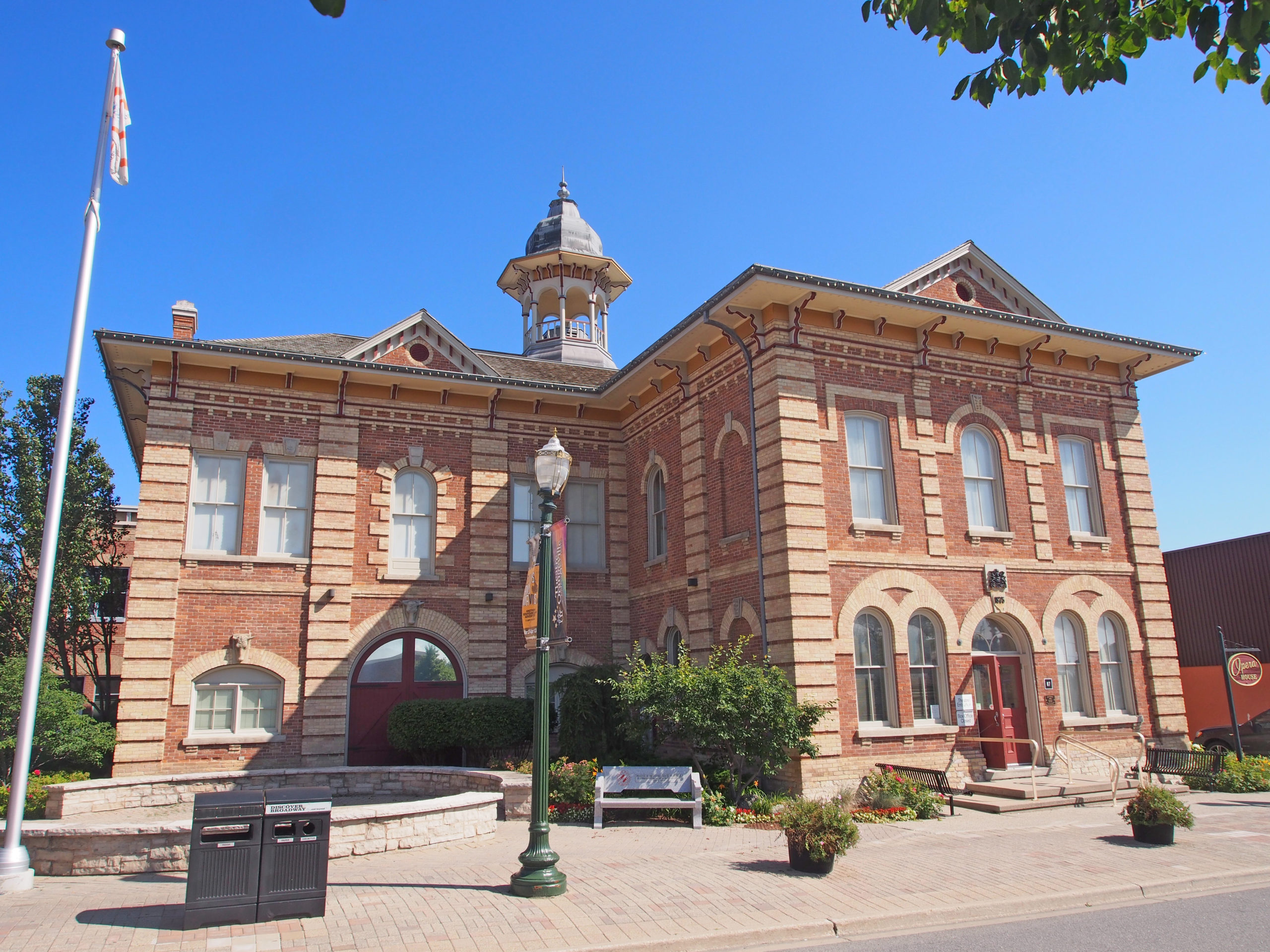
16-18 Wellington Street – King House c. 1888 – Second Empire style – large brick house, mansard roof, ornamental ironwork – Orangeville Book 187 Broadway – Orangeville Town Hall – built to serve as town hall, municipal offices, market area, opera house – c. 1875 – Italianate architecture with projecting roof eaves, paired cornice brackets, pedimented roof line, and use of contrasting brick colors – the cupola is a prominent feature – Orangeville Book 2269 Broadway – Italianate – wide porch, pediment (low gable over the door) with decorated tympanum, Ionic capitals on the pillars – Orangeville Book 2283 Broadway – Romanesque – massive shape, tower on side and front, large arches over windows – Orangeville Book 251 Zina Street – Dufferin County Court House – Classic Revival style built in 1880 with three towers that project from the facade, the center one most prominent; buff brick for decorative window hoods, bands, panels; cornice and capitals on red brick pilasters; projecting gable ends with triangular pediments and decorated tympanums – Orangeville Book 31st Line and Highway 9 – Italianate style – decorative verge board on gable, paired cornice brackets, quoining on center tower and corners, rounded window voussoirs with keystones – Orangeville Book 3
Peterborough is a city on the Otonabee River in central Ontario, 125 kilometers (78 miles) northeast of Toronto. Peterborough’s nickname of “The Electric City” underscores the historical and present day importance of technology and manufacturing as an economic base of the city which has operations from large multi-national companies such as Seimans, Rolls Royce, and General Electric. Peterborough is known as the gateway to the Kawarthas, “cottage country”, a large recreational region of the province. In 1818, Adam Scott settled on the west shore of the Otonabee River and the following year he began construction of a sawmill and gristmill, establishing the area as Scott’s Plains. The mill was located at the foot of present-day King Street and was powered by water from Jackson Creek.
The year 1825 marked the arrival of 1,878 Irish immigrants from the city of Cork, a British Parliament experimental emigration plan to transport poor Irish families to Upper Canada. The scheme was managed by Peter Robinson, a politician in York (present-day Toronto). Scott’s Plains was renamed Peterborough in his honor. The Irish emigrated from the Emerald Isle to escape over-crowding, poverty, political unrest, religious tensions, disease and the potato famine. By 1851 almost half of the town of Peterborough claimed Irish ancestry. They cleared the land in the rolling hills of the Peterborough countryside.
In 1845, Sandford Fleming, inventor of Standard Time and designer of Canada’s first postage stamp, moved to the city to live with Dr. John Hutchison and his family, staying until 1847. Dr. John Hutchison was one of Peterborough’s first resident doctors.
359 Downie Street – Second Empire style, mansard roof, window hoods, 2 story bay windows – Peterborough Book 1232 Brock Street – Italianate, cornice brackets, two-story bay windows, second floor balcony – Peterborough Book 2413 Rubidge Street – Grover Nichols House – an outstanding example of Greek Revival architecture, modified in the Palladian manner, it was begun about 1847 by P.M. Grover, a well-to-do local merchant. The square pillars are a Classical Greek feature. The local Masonic Lodge held its meetings here from 1849 to 1853 and the Masons purchased this imposing house in 1950. – Peterborough Book 2An elegant example of a residential terrace in the Second Empire style, Cox Terrace, 332-344 Rubidge Street, was constructed in 1884 during a time of prosperity and rapid urban growth in Peterborough. In this row of houses, inspired by British models, seven dwellings are skillfully unified behind one facade with three projecting pavilions. Mansard roofs, dormers, and oriel windows give life to the distinctive design. The terrace was built for Sir George Cox, one of the wealthiest and most influential Canadian businessmen of the period. – Peterborough Book 2George Street corner – Second Empire style, window hoods on dormers, banding on top floor; cornice brackets, dentil molding, pilasters on 2nd floor; Romanesque style window voussoirs and keystones on ground level – Peterborough Book 2The Peterborough Lift Lock was completed on July 9, 1904. It was the first lock to be built out of concrete and at the time was the largest structure built in the world with unreinforced concrete. It is a boat lift located on the Trent Canal in the city of Peterborough and is Lock 21 on the Trent-Severn Waterway. The dual lifts are the highest hydraulic boat lifts in the world, with a lift of 19.8 m (65 feet). – Peterborough Book 3McDonnel Street – Peterborough Collegiate circa 1917 – Romanesque Revival architecture – Peterborough Book 3
Ayr is located south of Kitchener and west of Cambridge, and south of Highway 401.
In 1824, Abel Mudge built a saw mill and flour mill at the junction of Cedar Creek and the Nith River. This was the first of three settlements, Jedburgh in the east (Main Street), Nithvale in the west (Piper Street) and Mudge’s Mill in the center (Stanley/Northumberland Streets) in what is today the Village of Ayr.
Jedburgh began in 1832 when John Hall, a young immigrant from Jedburgh, Scotland, purchased a 75-acre parcel of land that included the area now flooded by Jedburgh Dam. By 1850 Hall had developed several industries, including a flour mill, sawmill and distillery with water power provided by the damming of Cedar Creek. At the same time a smaller settlement, Nithvale, was founded to the west of Mudge’s Mill where a small sawmill opened along the Nith River.
In 1840 when Robert Wyllie established a post office it was given the name “Ayr”, a name influenced by the large number of former Ayrshire, Scotland immigrants who were drawn to Canada by promises of inexpensive, fertile land.
In 1846–47 Daniel Manley’s mill was built, William Baker’s store was established and John Watson’s foundry constructed with Watson’s Dam its power reservoir. These three key businesses played large roles in Ayr’s early success as did the coming of the Credit Valley Railway in 1879. James Somerville began the first Ayr newspaper in 1854.
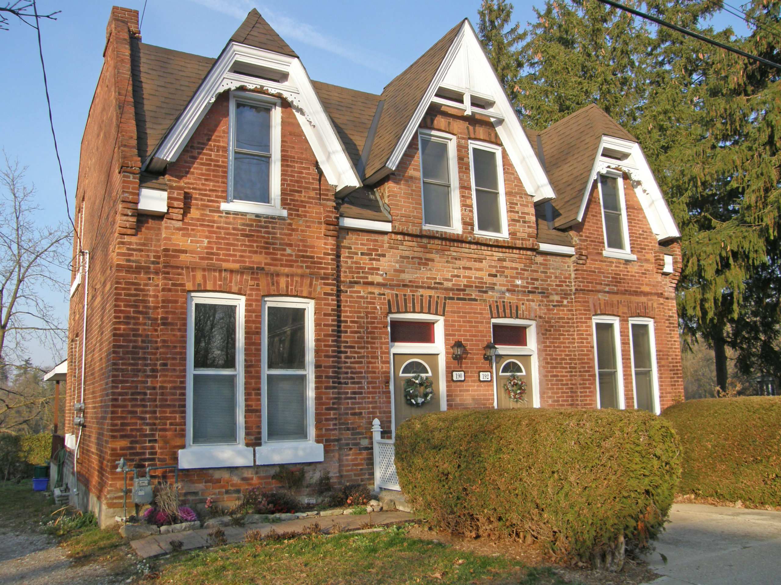
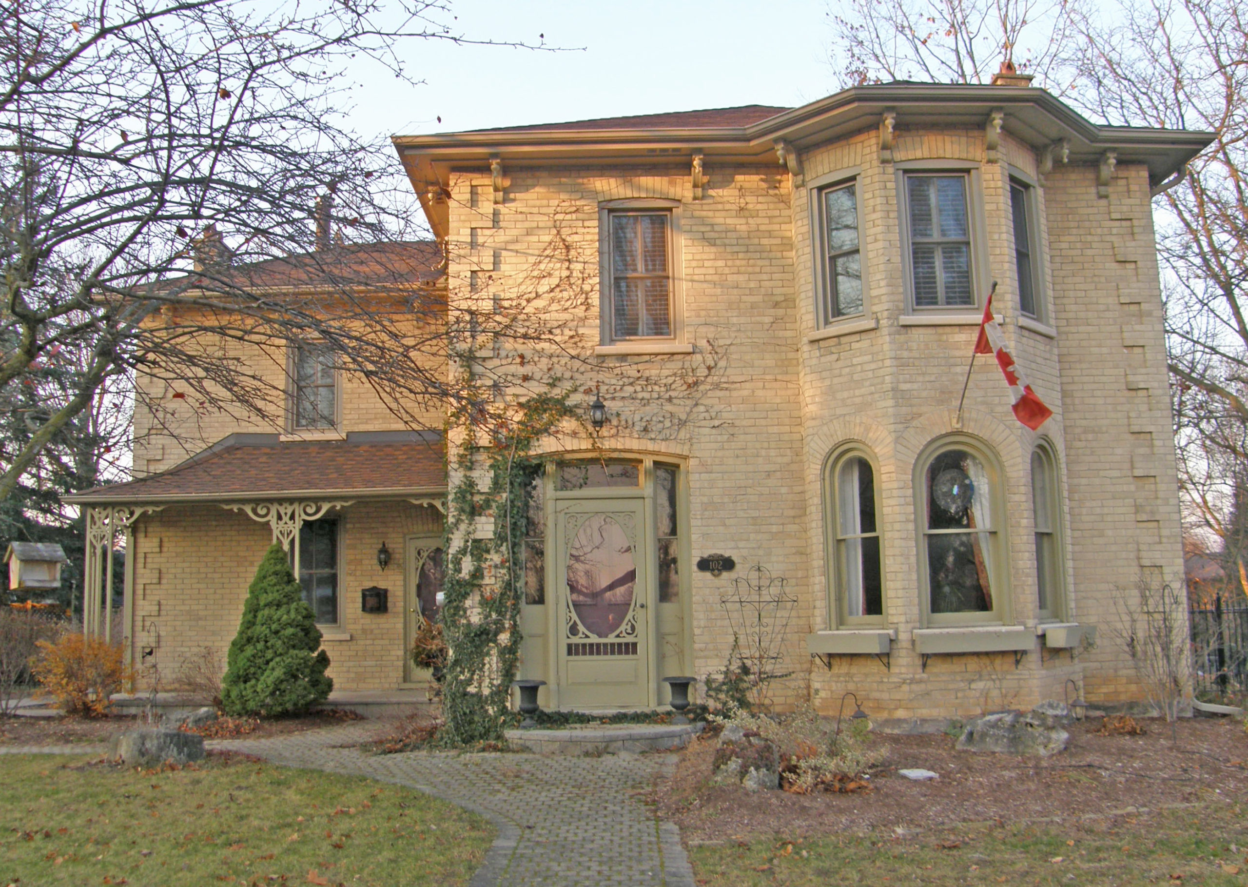
#190 and #192 – Triple-gable Gothic Revival style40 McDonald Street – Second Empire style, mansard roof with dormers, yellow brick, cornice brackets, corner quoins42 McDonald Street – yellow brick, verge board trim, corner quoins102 Main Street – Italianate – hip roof, yellow brick, two-story bay window, corner quoins, cornice brackets105 Hall Street – Ayr Public School – 1890 – cupola, Romanesque style window arches, bell tower, pediment, dentil molding
Guelph, known as “The Royal City”, is located 100 kilometers (62 miles) west of downtown Toronto at the intersection of Highways 6 and 7. Guelph was founded on St. George’s Day, April 23, 1827, the feast day of the patron saint of England. The town was named to honor Britain’s royal family, the Hanoverians who were descended from the Guelfs, the ancestral family of George IV, the reigning British monarch.
John Galt designed the town to resemble a European city center with squares, broad main streets and narrow side streets, resulting in a variety of block sizes and shapes. The street plan was designed to resemble a lady’s fan with many of the streets forming triangles (the segments of the fan).
The first cable TV system began in Guelph with their first broadcast being the coronation of Queen Elizabeth II in 1953. The Speed and Eramosa Rivers flow through the city.
Riverside Park is an 80-acre park built around a portion of the Speed River that runs through Guelph. The park opened in 1905.
The Ontario Agricultural College, the oldest part of the University of Guelph, began in 1873 as an associate agricultural college of the University of Toronto. The Government of Ontario purchased 550 acres of land from F. W. Stone to build the college. In 1964, the Ontario Agricultural College, Ontario Veterinary College and Macdonald Institute combined to become the University of Guelph and Wellington College.
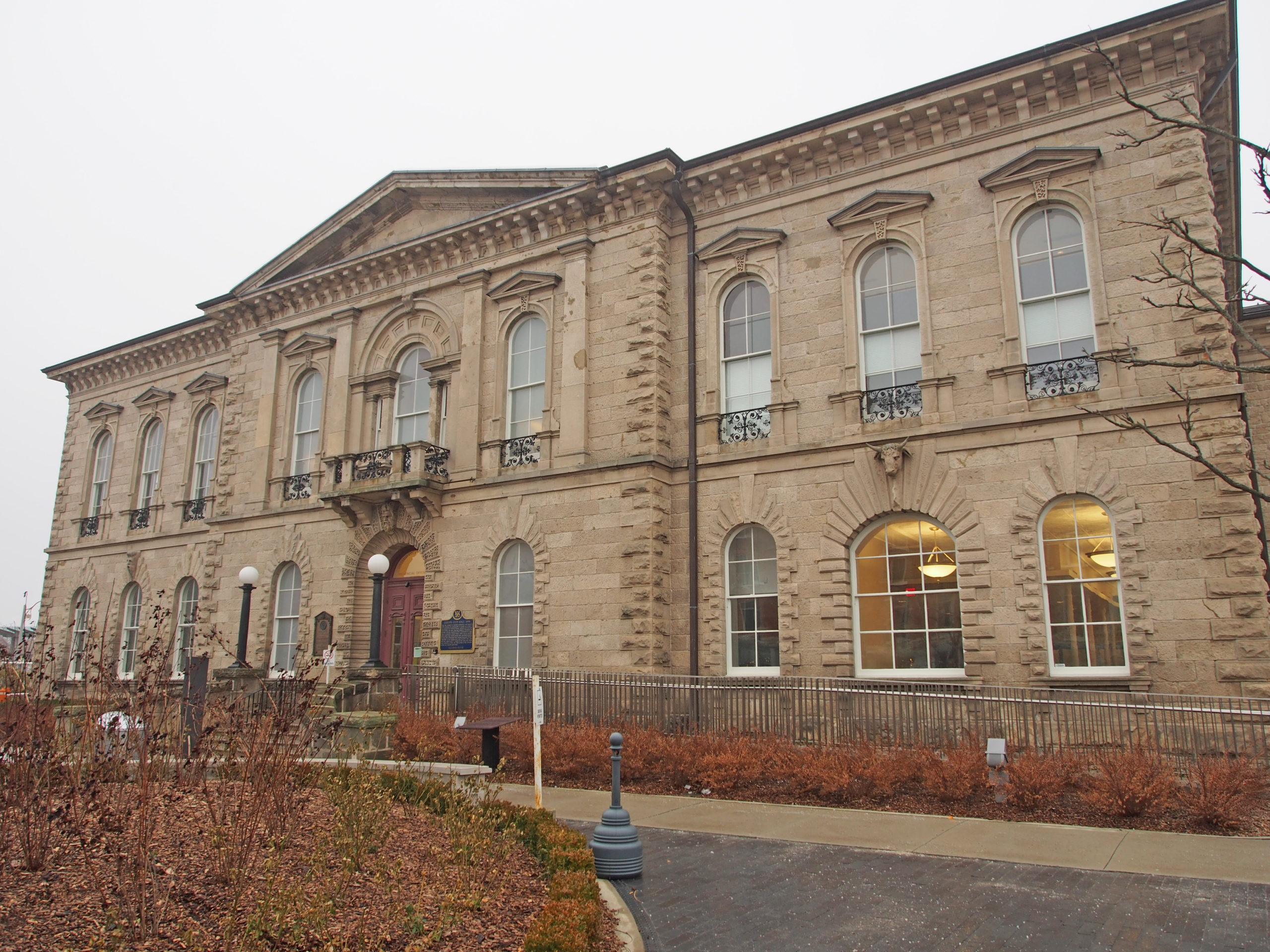
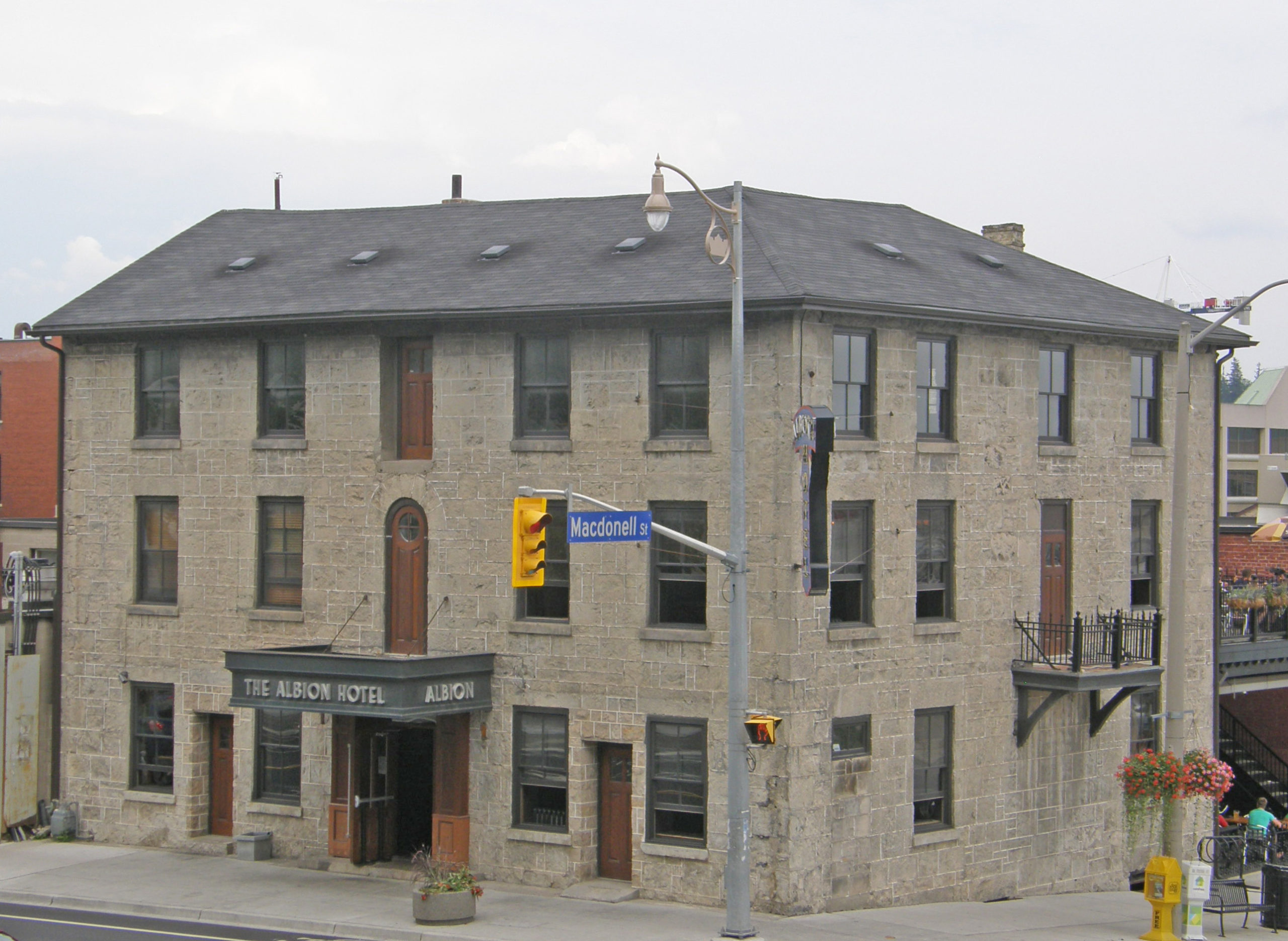
Guelph City Hall, 1 Carden Street, was built in 1857 using locally quarried Lockport Dolomite, and was fashioned in the Renaissance Revival style. When the building opened in 1857, Guelph had 4,500 residents. Pediment, cornice brackets, corner quoins – Guelph Book 1The building was constructed about 1867 of limestone from local quarries, and its structure is supported from the basement by 18-inch timbers. During the late nineteenth century, The Albion Hotel, along with twenty other hotels in the area, served the needs of farmers coming into town for the weekly market and the Provincial Fair in front of City Hall. – Guelph Book 1Douglas Street – Crown Attorney’s Office – 1885 – corner quoins, banding, arched window hoods with keystones – Guelph Book 121 Stuart Street – Georgian style, belvedere, eyebrow windows in roof, window voussoirs with keystones, portico – Guelph Book 1143 Norfolk Street – Iron cresting above octagonal belvedere – Guelph Book 2Red brick – Queen Anne style, three-story tower, bay window on side, pediment above verandah – Guelph Book 2S.S. No. 1 Guelph Township School – A.D. 1873 – where I attended Grades 1 to 6 from 1957-63 – Limestone, paired cornice brackets – Guelph Book 2
Burlington is located at the western end of Lake Ontario, lying between the north shore of the lake and the Niagara Escarpment, north of Hamilton. Before pioneer settlement in the 19th century, the area was covered by old-growth forest and was home to various First Nations peoples. In 1792, John Graves Simcoe, the first lieutenant governor of Upper Canada, named the western end of Lake Ontario “Burlington Bay” after the town of Bridlington in Yorkshire, England. Land beside the bay was deeded to First Nations Captain Joseph Brant at the turn of the nineteenth century. With the completion of the local survey after the War of 1812, the land was opened for settlement. Early farmers prospered because of the fertile soil and moderate temperatures. Lumber from the surrounding forests was a thriving business. In the latter half of the nineteenth century, local farmers switched to fruit and vegetable production. The first peaches grown in Canada were cultivated in the Grindstone Creek watershed in the south-west part of the city.
Hamilton Harbour, the western end of Lake Ontario, is bounded on its western shore by a large sandbar. A canal bisecting the sandbar allows ships access to Hamilton Harbour. The Burlington Bay James N. Allan Skyway, part of the Queen Elizabeth Way, and the Canal Lift Bridge allow access over the canal.
The leading industrial sectors are food processing, packaging, electronics, motor vehicle/transportation, business services, chemical/pharmaceutical and environmental.
Burlington is home to the Royal Botanical Gardens, which has the world’s largest lilac collection.
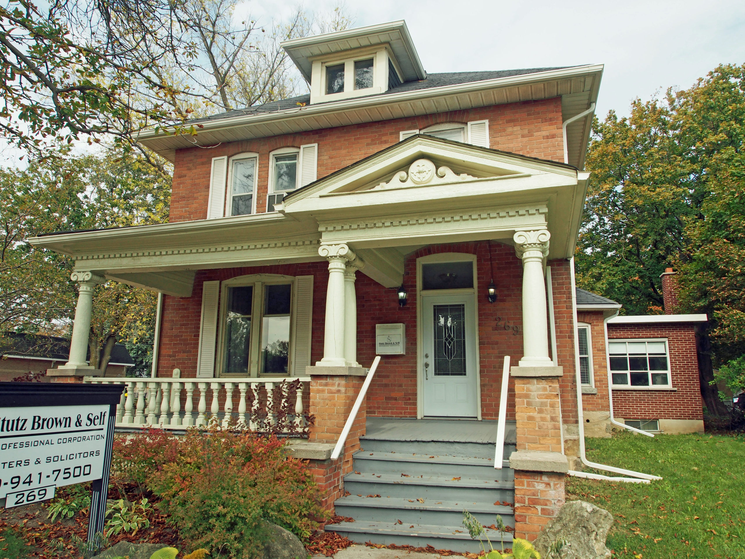
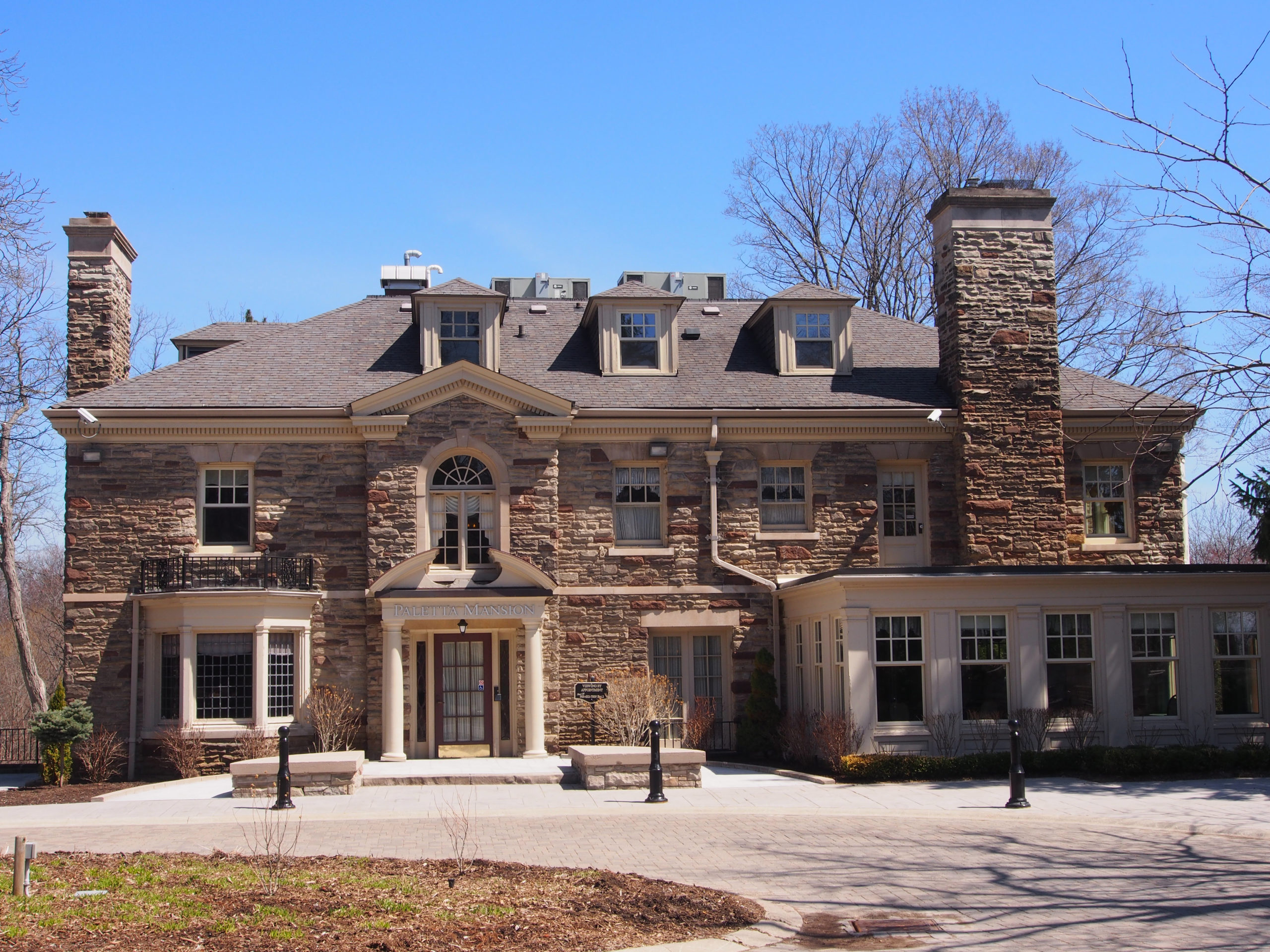
Paletta Mansion – In 1809, the British Crown, under King George III, granted Lot 8, Concession 4 South of Dundas Street to Laura Secord, who was later to distinguish herself as a heroine in the events of the Battle of Lundy’s Lane during the War of 1812. Laura Secord and her family did not settle in Nelson Township but conveyed the lot to settler John Beaupre in 1810. (Enjoy my novel that tells about Laura, Laura Secord Discovered.) Over the next one hundred years the property passed through about fifteen different families. In 1912, it was purchased by William Delos Flatt and Cyrus Albert Birge. The site was used as a park by local residents for leisure pursuits such as swimming, boating and fishing, while the rest of the property continued in use as a fruit farm. Following the death of the prominent Hamilton industrialist Cyrus Birge in 1929, his daughter Edythe MacKay used her inheritance to replace the old Zimmerman farmhouse on her Shore Acres Estate. It was built by local contractors and craftsmen with the finest imported and local materials. The mansion stands on a fourteen acre property on the Burlington waterfront. This three story, 11,000 square-foot mansion has original hardwood floors throughout, seven working fireplaces, many original fixtures and decorations with a relaxed charm and intimacy.2201 Lakeshore Road – Gothic Revival, corner quoinsBurlington Avenue – Queen Anne – verge board trim, decorative brickwork below cornice, half-moon window, fish scale pattern on tower1401 Ontario Street – Gothic Revival – cornice return on gables, full verandah on second floor560 Brant Street – Neo-colonial – gambrel roof
Brantford is located on the Grand River in Southern Ontario. Brantford is connected to Woodstock in the west and Hamilton in the east by Highway 403 and to Cambridge to the north and Simcoe to the south by Highway 24. Brantford is known by the nickname The Telephone City as former city resident Alexander Graham Bell conducted the first distant telephone call from the community to Paris, Ontario in 1876. It is also the birthplace of hockey player Wayne Gretzky.
In 1784, Captain Joseph Brant and the Six Nations Indians of the Iroquois Confederacy left New York State for Canada. As a reward for their loyalty to the British Crown, they were given a large land grant on the Grand River. The original Mohawk settlement was on the south edge of the present-day city at a location favorable for landing canoes. Brant’s crossing of the river gave the original name to the area: Brant’s ford. By 1847, European settlers began to settle further up the river at a ford in the Grand River and named their village Brantford. It was incorporated as a city in 1877.
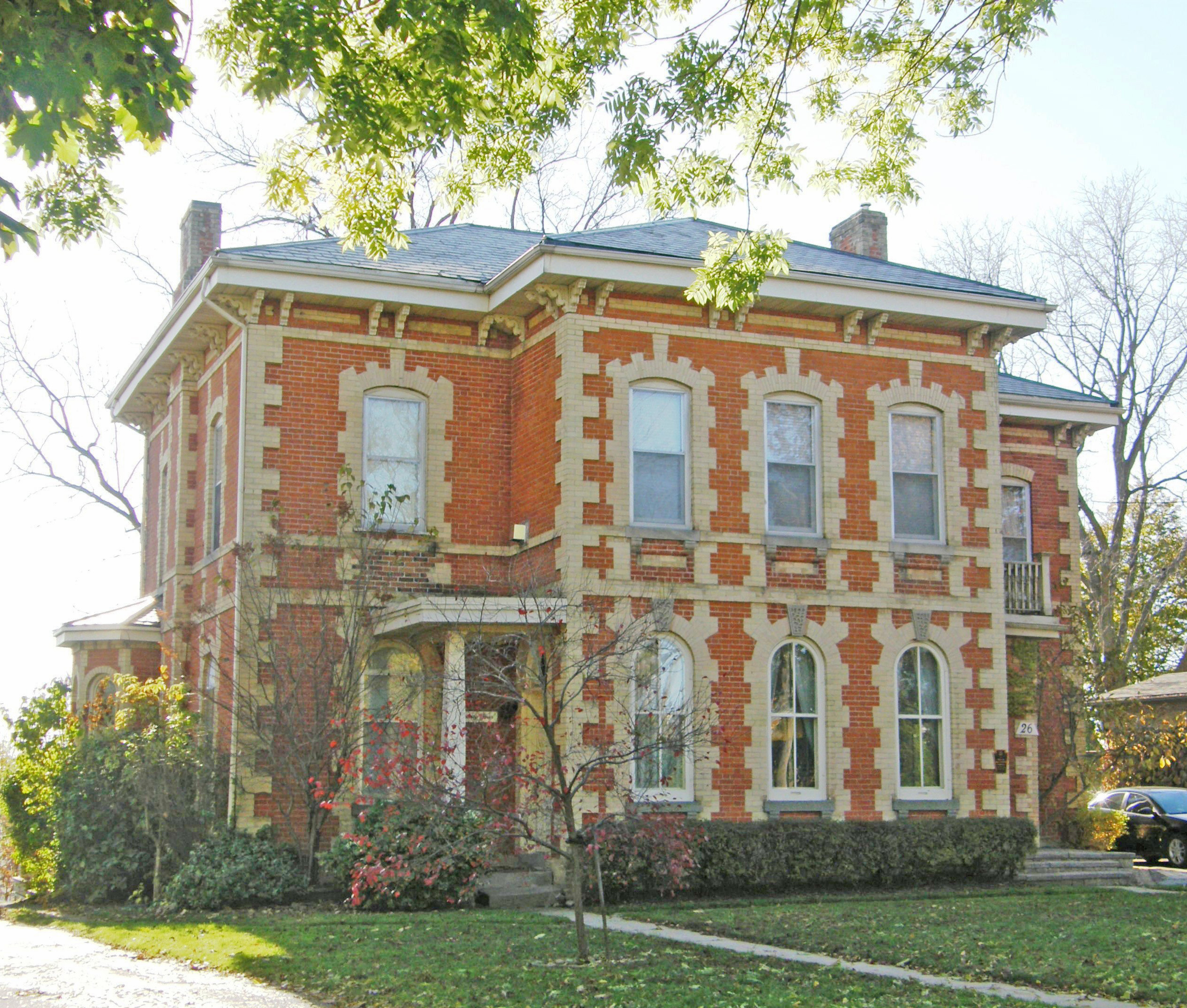
Laurier Brantford – Ionic capitals on pillars, pedimentSC Johnson Building – corner Dalhousie & Market Streets, mansard roof with dormers with triangular window hoods, Ionic capitals26 Lorne Crescent – Italianate – 1875 – dichromatic brickwork, paired cornice brackets, bay window on side#30 – 1896 – Queen Anne style – round turret#102 – Italianate, hipped roof, paired cornice brackets, corner quoins
The earliest European settlers to arrive and clear land in the mid-18th century in what would eventually become Ancaster were made up of American farmers traveling north searching for arable land, French-speaking fur traders, and British immigrants. Also arriving into this area around 1787 with the incentive of inexpensive land grants were the United Empire Loyalists loyal to the British crown who were fleeing from the United States after the 1776 American War of Independence. Britain’s promise of free land brought many people who did not exhibit the same loyalty to the crown as the Loyalists. This eventually led to a series of defections, accusations and treasonous acts during the War of 1812 that precipitated the largest mass hangings in Canadian history, the so-called Bloody Assizes whose trial took place in Ancaster in 1814.
#535 – Gothic Revival style with center gableWilson Street – limestone building, gingerbread trim, second floor verandah375 Wilson Street East – Rousseau House – built in 1838 by George Brock Rousseau, postmaster of Ancaster for ten years311 Wilson Street East – Italianate, belvedere, paired cornice brackets, sidelights surrounding door117 Wilson Street West – c. 1855 – Gothic Revival, two-story red brick house, verge board trim and finials on gables, corner quoins, bay windowsWilson Street West – two-story red brick, second floor balcony under gable which has stenciling on the verge board trim, dormer, bric-a-brac on lower porch