Clinton Township included the villages of Beamsville, Vineland, Campden and Tintern. Many of the early settlers were Mennonites who emigrated from Pennsylvania.
Beamsville, Ontario was named after Jacob
Beam, a United Empire Loyalist. Jacob and Catharine, along with their daughter
Catharine and son-in-law Samuel Merrell, immigrated to Canada from New Jersey
in 1788, and founded Beamsville. It was located on the Great Western Railway.
In 1898, hockey players in the town of Beamsville were the first to make use of
a hockey net.
In 1970, the Town of Beamsville was amalgamated
with Clinton Township and half of Louth Township to form the larger Town of
Lincoln. Beamsville is in the heart of Ontario’s wine country in the Niagara
Peninsula. Many wineries from the area have received top awards, including
Grape King at the Niagara Grape & Wine Festival, as well as international
awards.
Vineland is bordered by the
Twenty Mile Creek and Jordan to the east, Lake Ontario to the north, Beamsville
to the west, and Pelham to the south. Vineland is primarily an agricultural
community with many fruit farms and wineries. Vineland’s fruit crops include cherries,
peaches, apples and pears.
Most of the early settlers of
Jordan were German in origin, and were devout practicing Mennonites. With a
large natural harbor at the mouth of Twenty Creek, Jordan became a busy
shipping center for the export of logs for boat masts, tan bark, hides, ashes
used in industrial centers for the manufacture of soap, as well as grain,
flour, fruit and fruit products. A small ship building industry existed for a
time on the banks of the Twenty.
Ball’s Falls is a historical ghost town
located in the Niagara Region and dates back to the early 19th
century when it was established by Jacob Ball, a United Empire Loyalist. After
the American Revolution, Jacob and his family were forced from their home and
potash works in New York. Twenty Mile Creek, which runs through the area, has
two waterfalls. The Ball brothers built a grist mill, a saw mill at the lower
falls and a woolen mill at the upper falls. In the late 1850s, the Great
Western Railway was established and many industries moved away from here to be
closer to the railway. In 1962 Manly Ball sold the land to the Niagara
Peninsula Conservation Area and the town, now known as Ball’s Falls, is a
tourist attraction.
The first settlers of Campden were former members of Butler’s Rangers
who were granted land for their services to the Crown following the American
Revolution. Benjamin Doyle was one of these and he severed part of his land to
the newly arrived Pennsylvania Dutch, which included Jacob Moyer and his seven
sons. In 1862 when a post office was established, the hamlet was named Campden.
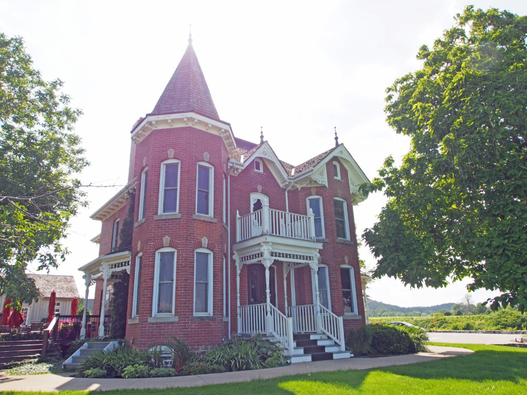
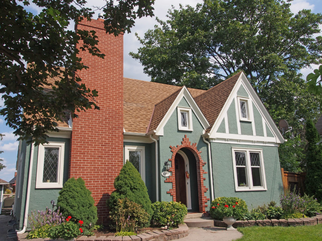
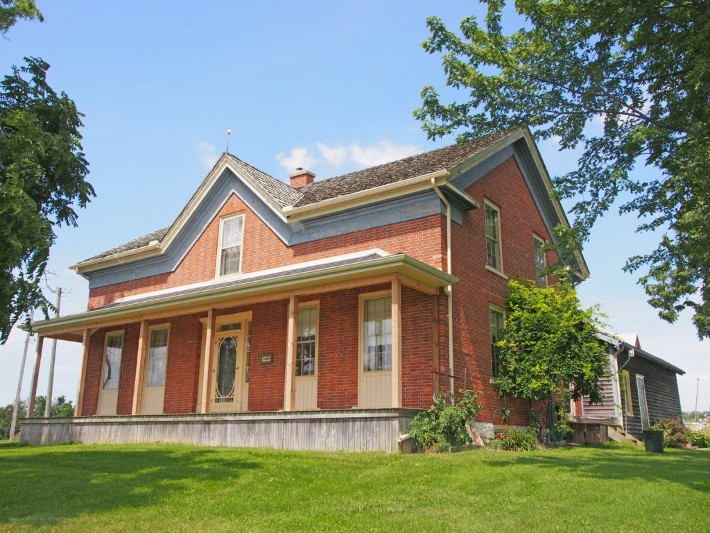
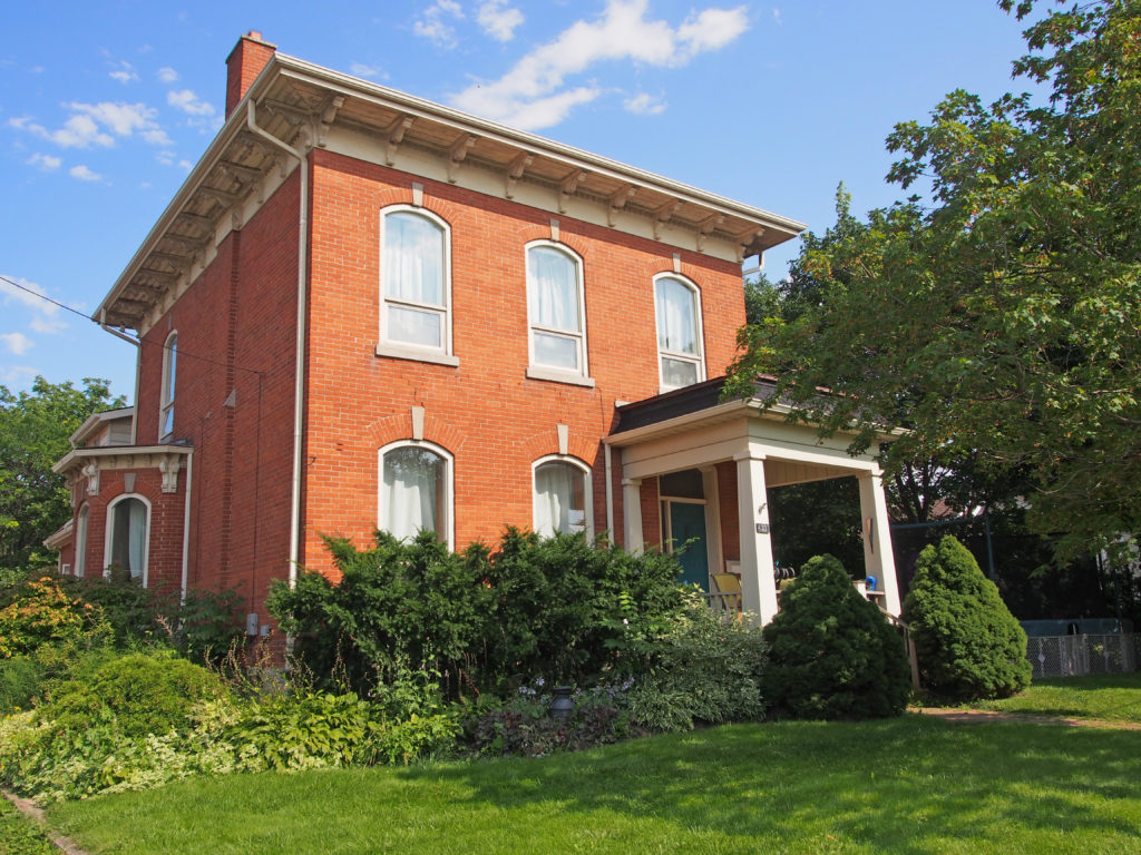
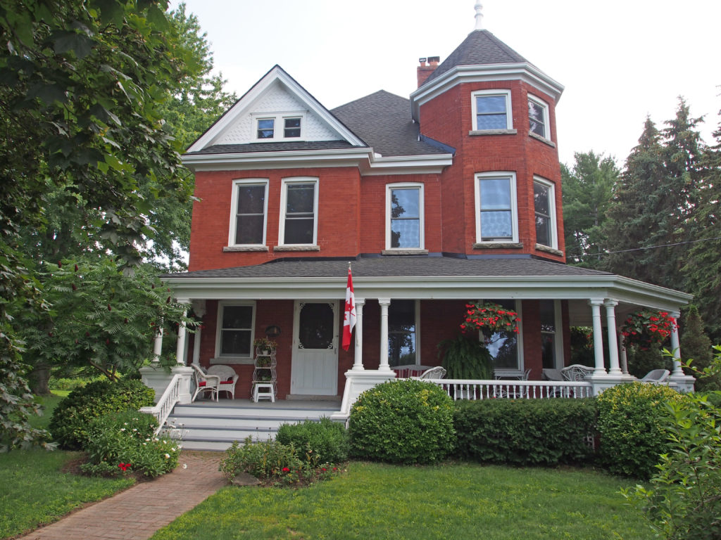
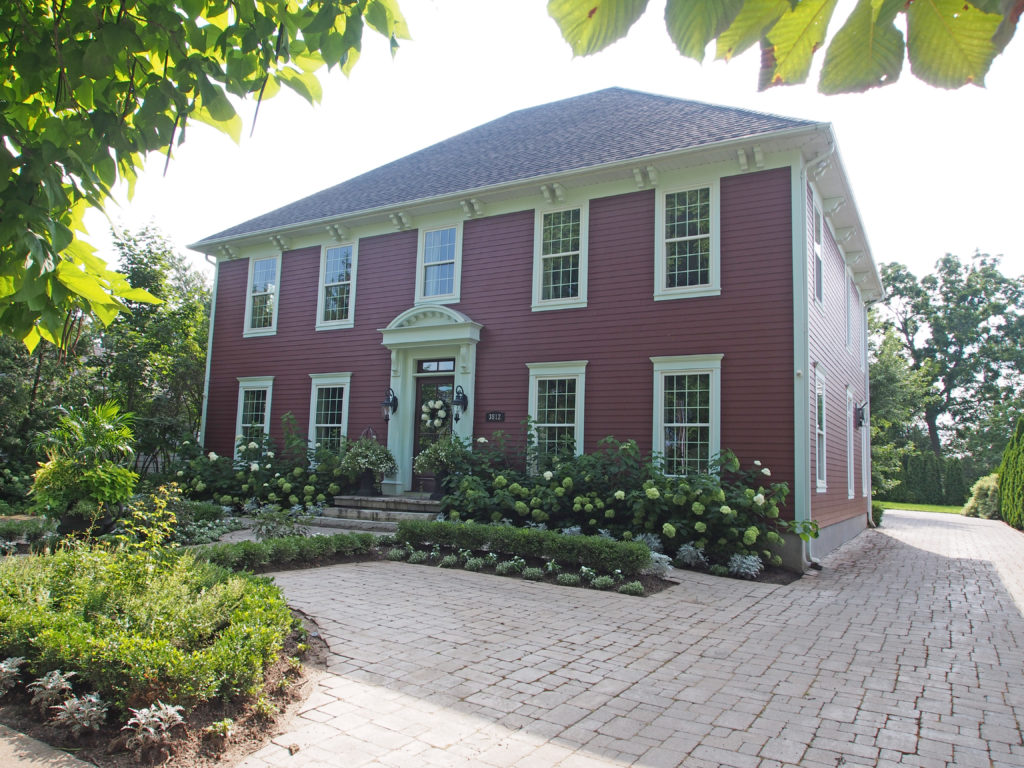
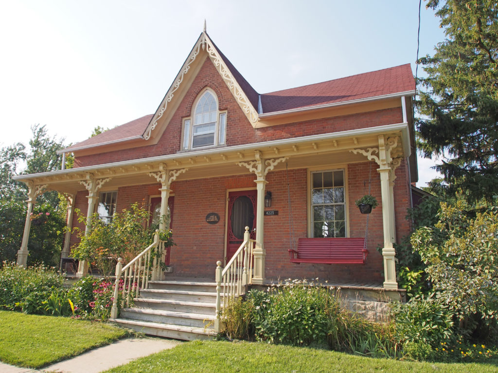
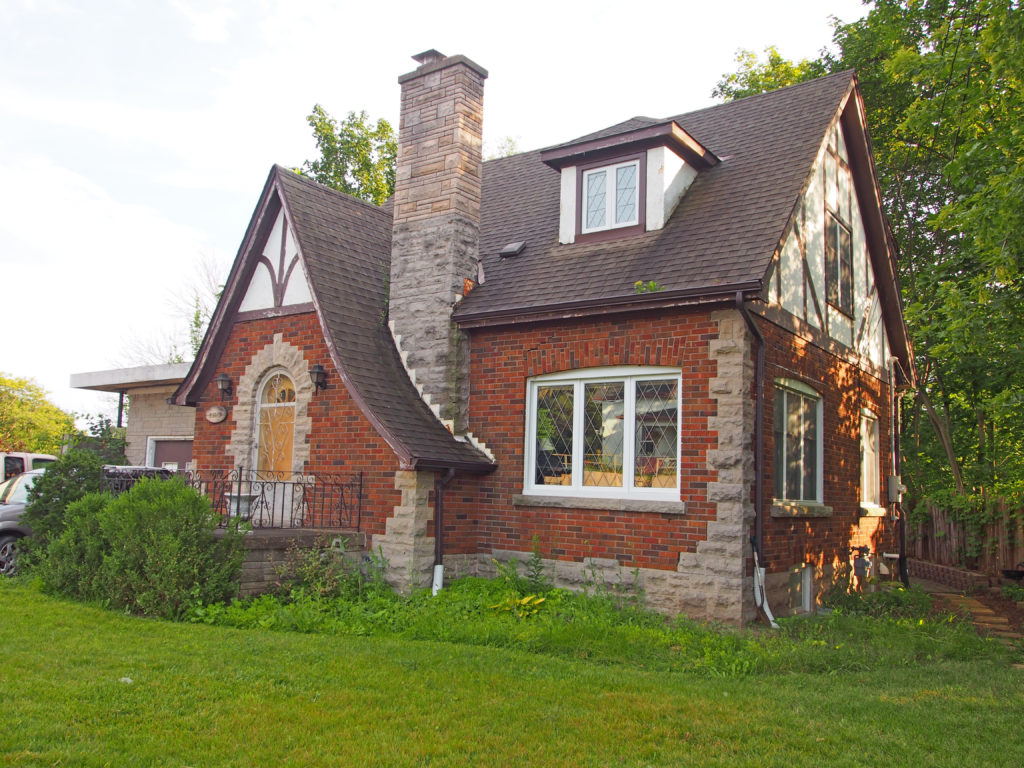
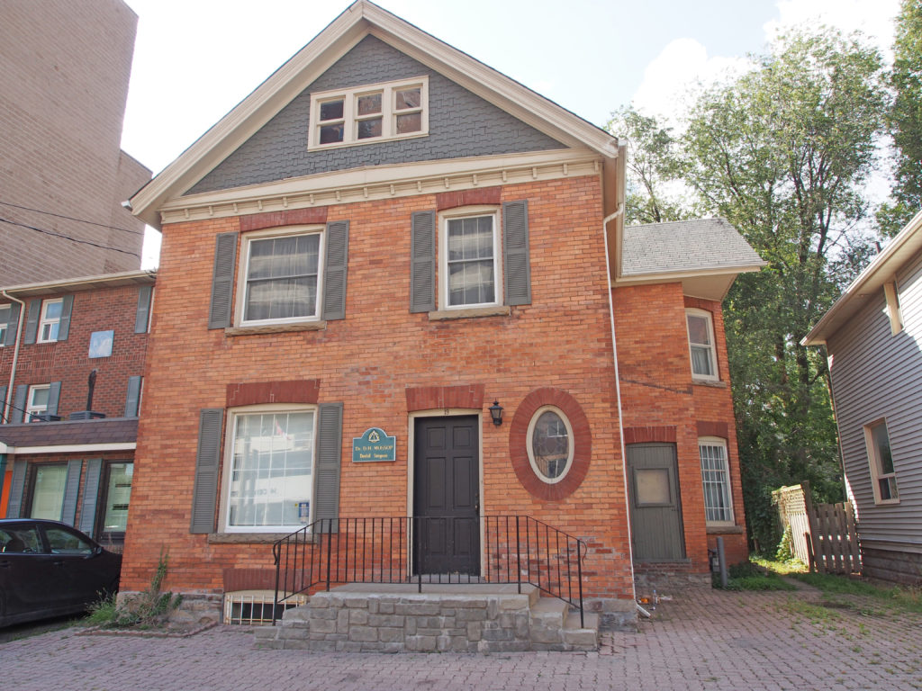
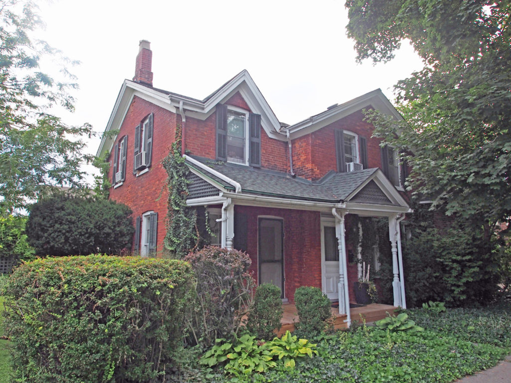
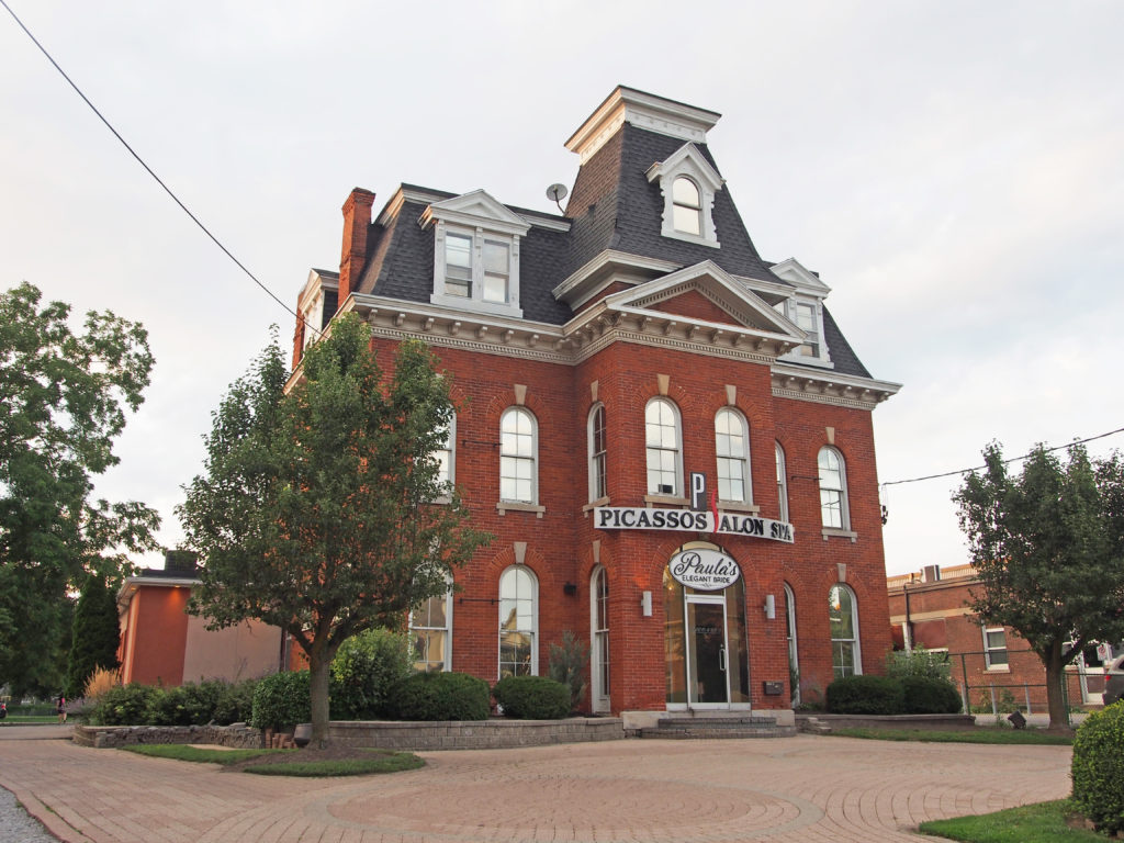
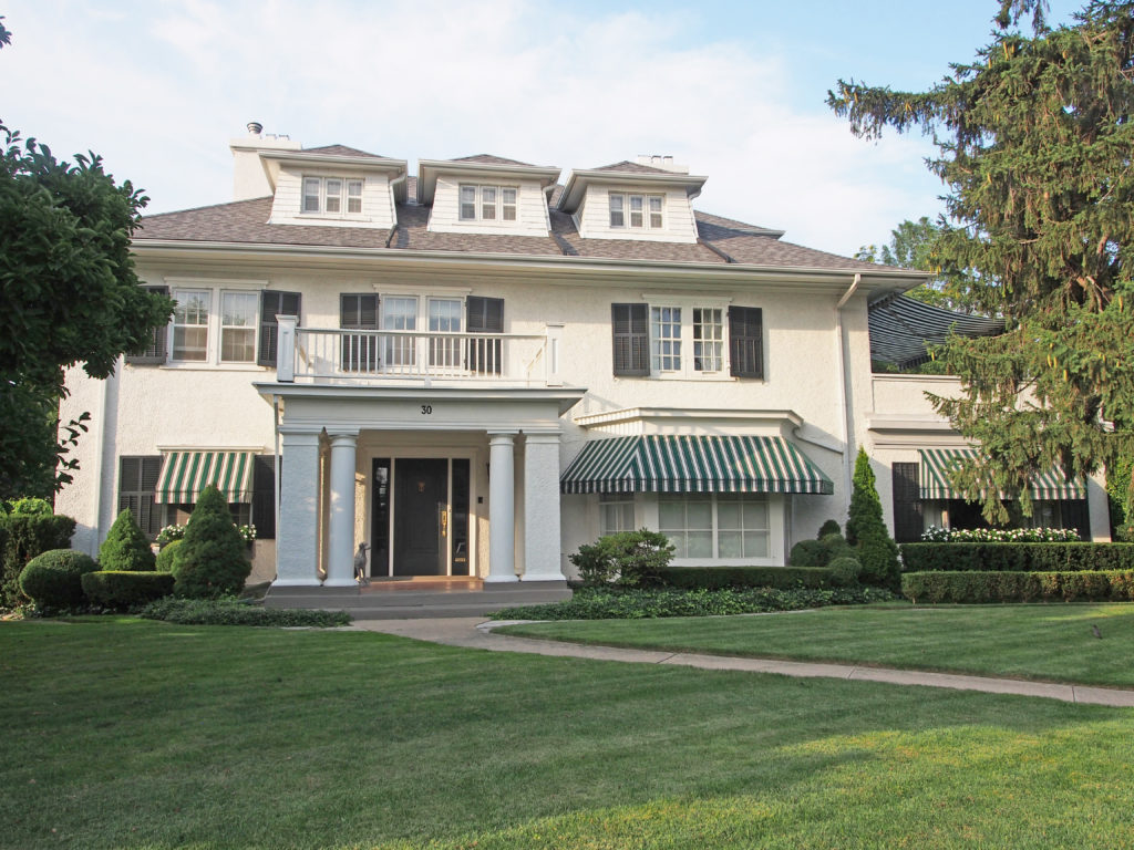
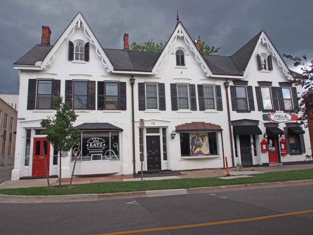
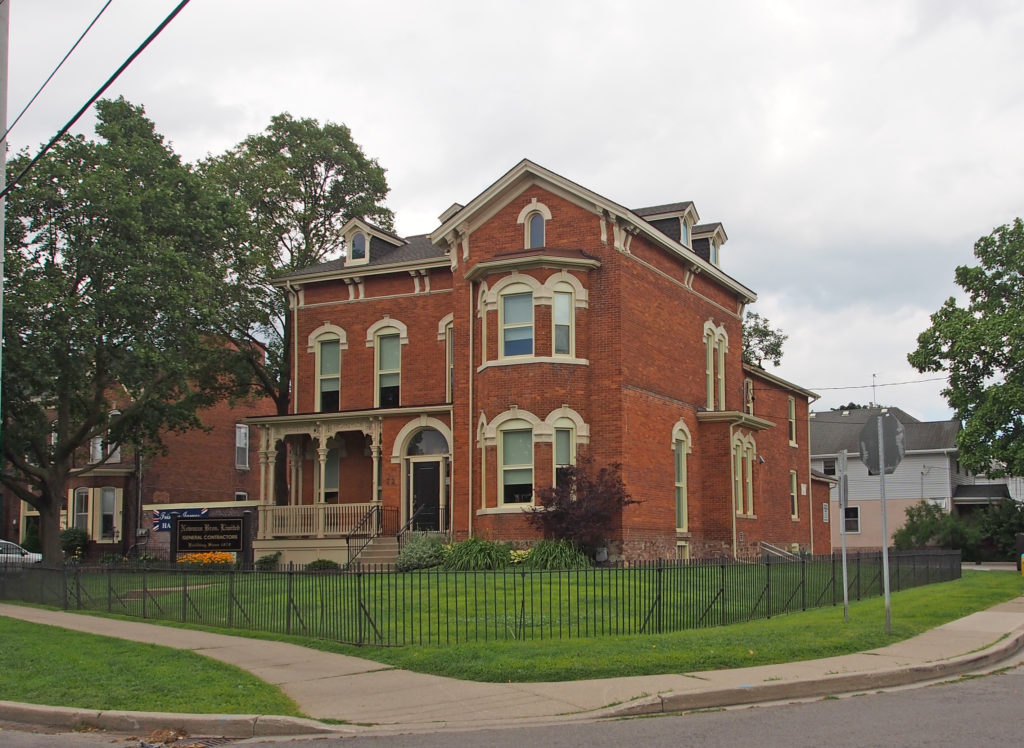
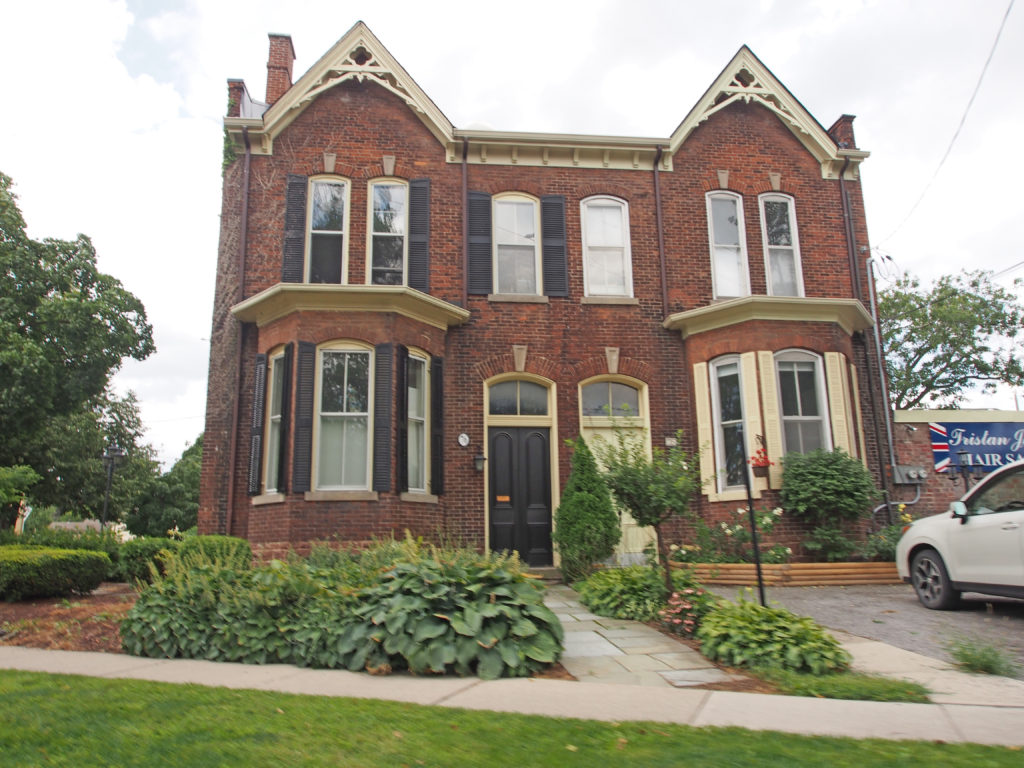
5600 King Street West, Beamsville – The property was a Crown Grant of 52 acres to a loyalist from New Jersey named William W. Kitchen around 1790. He married Alice Beam and together they had nine children. William and Alice’s youngest son, Jacob married Jane Dennis. Their only son, William Dennis Kitchen married Margaret Henry and built the house in 1885 on the bench of the escarpment, just west of the Thirty Mile Creek. The house was built in the Queen Anne Revival style with red bricks. The turret has square and rounded cedar shingles, topped with a finial. There are two tall corbeled chimneys, and a hipped roof with a flat belvedere. The gables have carved fretwork brackets and barge board. The tall bay windows are topped with segmental arches and decorative keystones. The front porch has an overhead balcony, and like the side porches, features turned posts, balustrades, spandrels and brackets. Purchased by the Longwell family in the 1920s, Doug and Jean Longwell continued to live there until the 1980s. From 1999 to 2009, the house was owned and restored by Norman and Sherry Beal, who transformed the property into an estate winery. In 2009 Wendy Midgley and her husband Chef Ross Midgley purchased the Kitchen House and the Coach House from the Beals.5053 King Street, Beamsville – Beam Barnes House c. 1855 – The property was originally granted by the Crown to Samuel Corwin in 1803. His wife was Anna Beam, daughter of Loyalist pioneer Jacob Beam. Her brother, Jacob Beam Jr. built the house between 1852 and 1855. The frame house is an early version of the Gothic Revival style. Notable features are steeply pitched gable roofs with carved finials and cut out quatrefoils worked into the barge board on both the front façade and east wing. The veranda has simple square posts, and the front door has a paned transom and sidelights. The tops of the slender but widely framed windows are surrounded with shaped lintels and decorative keystones.5074 King Street, Beamsville – bay window with iron cresting above4918 King Street, Beamsville – Woodburn Cottage – The land was originally deeded by Crown Patent to Jacob Beam in 1801. The house built about 1834 for James B. Osborne, a merchant, postmaster and private banker. He was a prominent member of the community. The name “Woodburn†is said to have derived from James Osborne’s second wife’s family. The house is Regency Cottage in style. It is built of Flemish double stretcher bond red brick on top of a fieldstone foundation. The front façade has an impressive double door with sidelights and a fan transom housed in an arched brick surround. Flanking the doorway are four large, shuttered windows, each with twelve panes and flat stone lintels on top. The hipped roof has double-flued, corbeled chimneys on each corner and has a large belvedere on top.4277 William Street4271 Queen Street, Beamsville – Originally built as a school in 1847, the house is supported by a rubble stone foundation and hand-hewn beams. The house has a pitched gable roof and large double-hung windows. There are two pairs of smaller windows in both the front and back gables. It is now the Adult Learning & Resource Center for Niagara West.5567 Fly Road – The property was originally a Crown grant to Paul Marlatt in 1796. The Marlatts were part of the Huguenot migration from France to Virginia in the late 17th century. They moved to this area in the 1780s-1790s. James Durham bought the property in 1830 and he had the house built in 1832. The two-storey white stucco house has multiple-paned 12-over-12 windows and sidelights flanking either side of the front door.5031 Philp Road – Tufford Easton House – 1906 – Four-square asymmetrical 2½ storey house has a hip roof with a triangular-pediment-gabled dormer. It has a Queen Anne style wraparound veranda supported by seven square pillars.5499 Philp Road – The present house, of Neo-Classic Vernacular design, dates to about 1850 and utilizes hand-hewn beams and Flemish and triple brick construction. The five-bay façade has original windows and doors, with the front door flanked with sidelights and overhead transom. The main barn is a good unaltered example of an early 1800s Loyalist Barn in the English three bay style.4157 Maple Grove Road, Beamsville – St. Helen Roman Catholic Church4337 Ontario Street, Beamsville – hipped roof, cornice brackets, voussoirs and keystones3150 Culp Road, Vineland – Overholdt House – The house was built in 1900 by a wealthy shipping merchant named Moses Overholdt. Built in red brick in the Queen Anne style, the house features a hipped room with diamond-shingled gables with Palladian windows on the sides, a three-storey hexagonal tower protruding from the northwest corner and topped with a finial, a wrap-around veranda with double piers on large bases, a tall corbeled chimney, and segmented, double-hung windows throughout.3812 Main Street, Jordan Station – The Honsberger-Griffith house was erected in 1851 by Michael Honsberger, a local merchant and Post Master in the Village of Jordan. The house was built in the Georgian style using local bricks.4225 Fly Road, Campden – The Henry W. Moyer-Humphrey House was built circa 1870 in the hamlet of Campden in the former Township of Clinton. This house is believed to be the first brick house in the hamlet; several members of the Moyer family have lived in the house. Henry W. Moyer was a tinsmith, auctioneer, insurance agent and the first postmaster. It is a classic 1½ storey farmhouse with Gothic ornamentation on the three gables and the full-width veranda. The front façade has two front doors and two windows with finished cut and tooled stone doorsteps and window sills. The steps are positioned to the right of centre. Each of the five square posts is decorated with spandrel brackets and decorative scrolls. The pitched roof has a front central gable with a carved finial. The center pointed arch window has sidelights supported by double header brick. The gable has decorative barge board. The windows are six-over-six panes.
West Lincoln is a township in the Niagara Region of Ontario. Main
urban areas are located along provincial Highway 20. The administrative center
of West Lincoln is the community of Smithville, situated between Hamilton and
Niagara Falls.
Smithville was first settled by Richard Griffin and his family, United Empire Loyalists who came from Nine Partners, New York in 1787. The names of his sons were Abraham, Edward, Nathaniel, Isaiah, Smith, Jonathan, and Richard Jr. They settled on the Twenty Mile Creek in Grimsby (later South Grimsby) Township. Solomon Hill, who married Bethia, daughter of Richard Griffin, settled on Lot 6, Charles Meredith on Lot 7; Thomas Harris on Lot 11, and Thomas North on Lot 12. These lots, all in the 9th Concession became the settlement first known as Griffintown, but later renamed after Mrs. Griffin, whose maiden name was Mary Smith.
Edward “Ned” Griffin is sometimes
claimed to be the real founder of the village. He was the one who felled the
first tree, chose the village site, cleared the first acre of land, built the
first house, and lived his entire life in the village. Another son, Smith
Griffin, is credited with building a treadwheel in 1810. Settlers who wanted
their grain ground were required to provide their own motive power by putting
their oxen on the tread. Later, Smith Griffin built a dam and mill on the
Twenty Mile Creek, making the treadmill obsolete. Smith also started an ashery,
while his brother Edward opened a general store.
By 1849, Smithville had reached a population
of about 150, and had been granted a post office with twice-weekly delivery.
The settlement had a grist mill, a saw mill, a carding machine and cloth
factory, four stores, one machine shop, one tannery, two blacksmiths, two
tailors and two shoemakers.
Smithville, along with the remainder of
South Grimsby Township was amalgamated into the newly formed Township of West
Lincoln on January 1, 1970.
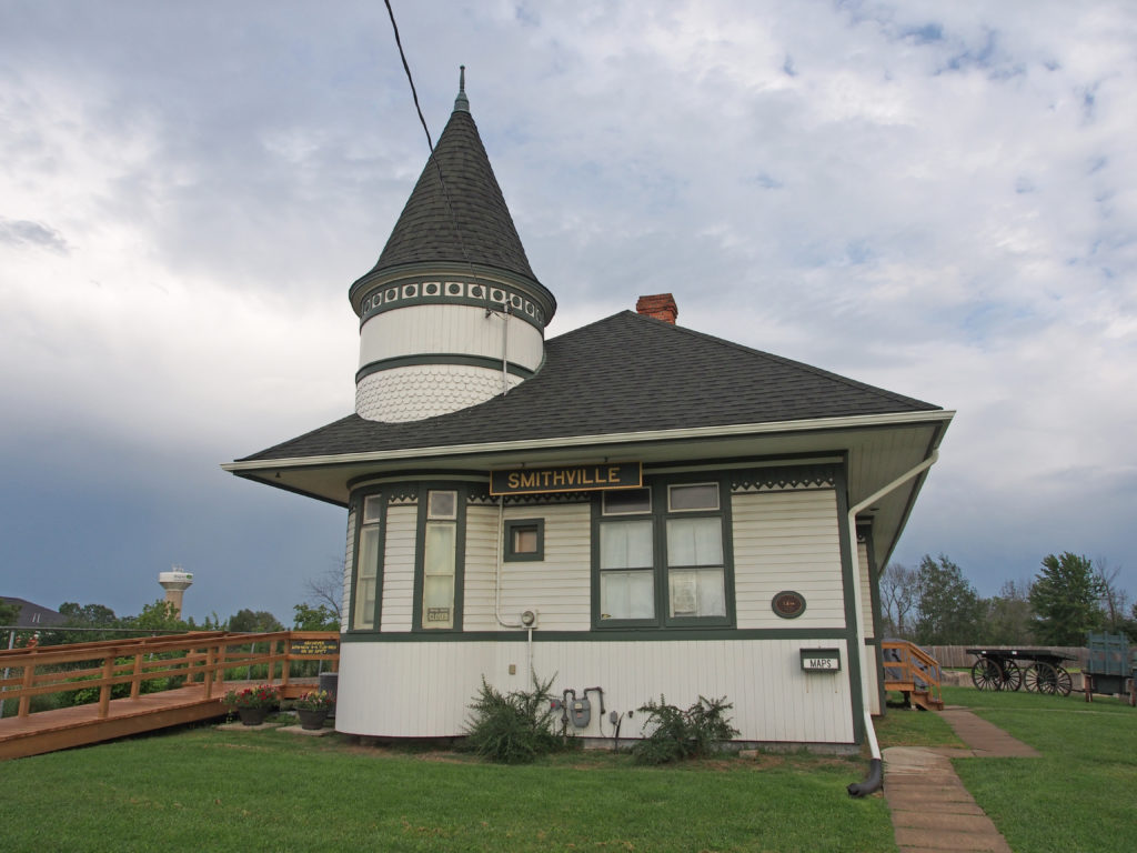
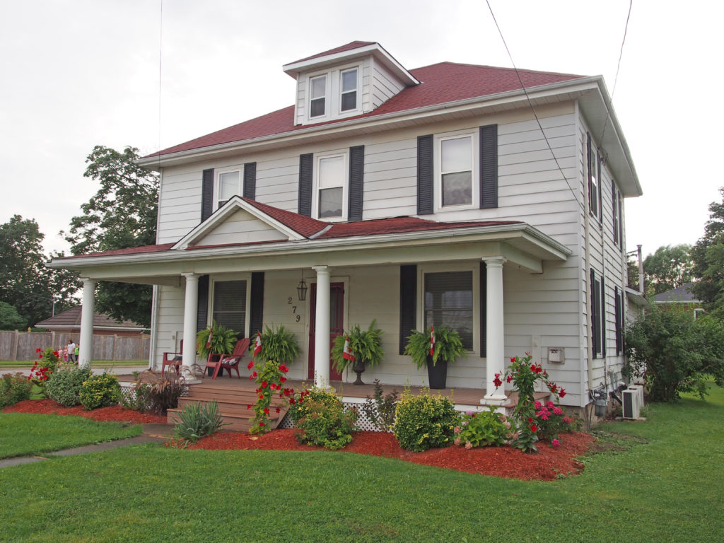
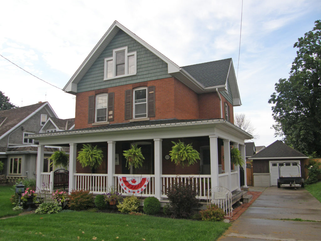
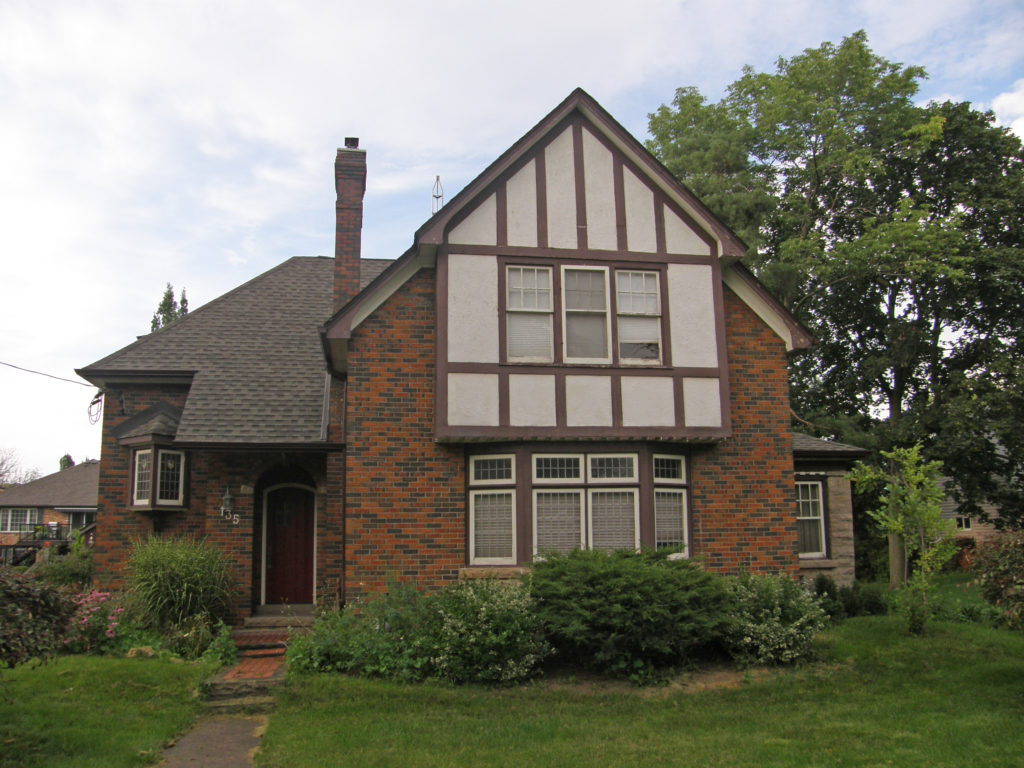
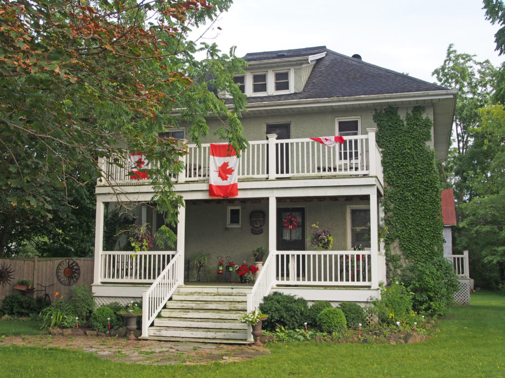
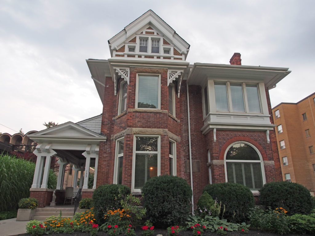
228 Station Street – Smithville Train Station established 1903 – hipped roof with turret with cone-shaped roof287 Station Street – two storey pillars support a pediment279 Station Street – dormer in the hipped roof of the two-storey home, Doric pillars supporting a veranda roof with a pediment121 West Street – Edwardian – Palladian window135 West Street – Tudor157 West Street – balanced façade120 St. Catharine Street – Arts and Crafts154 Griffin Street South – second floor full width balcony, dormer235 Canborough Street – Ionic capitals on the veranda pillars, pediment, verge board trim on gables, bay window
St. Catharines is the largest city in Canada’s Niagara Region in Southern Ontario. It is 51 kilometers (32 miles) south of Toronto across Lake Ontario, and is 19 kilometers (12 miles) inland from the international boundary with the United States along the Niagara River. It is the northern entrance of the Welland Canal.
The city was first settled by Loyalists in
the 1780s. The Crown granted them land in compensation for their services and
for losses in the United States. Early histories credit Sergeant Jacob Dittrick
and Private John Hainer, formerly of Butler’s Rangers, as among the first to
come to the area. They took their Crown Patents where Dick’s Creek and 12 Mile
Creek merge, now the city center of St. Catharines.
Secondary to water routes, native trails
provided transportation networks, resulting in the present-day radial road
pattern from the City center.
The small settlement was known as “The
Twelve” and as “Murray’s District” to military and civic
officials, but the local residents in 1796 and earlier referred to it as St.
Catharines.
The Merritt family arrived; they were among
the later Loyalists to relocate following the American Revolution. In 1796,
Thomas Merritt arrived to build on his relationship with his former Commander
and Queen’s Ranger, John Graves Simcoe, now the Lieutenant Governor of Upper
Canada.
The first Welland Canal was constructed from
1824 to 1833 behind what is now known as St. Paul Street, using Twelve Mile and
Dick’s Creek. William Hamilton Merritt worked to promote the ambitious venture,
both by raising funds and by enlisting government support. The canal
established St. Catharines as the hub of commerce and industry for the Niagara
Peninsula.
The Queen Street neighborhood has been
subject to historical development associated with the Merritt family. The
Niagara Peninsula saw considerable economic growth after the construction of
the first Welland Canal, a project initiated by William Hamilton Merritt, a
prominent land owner. The subdivision of his family’s estate in 1868 created
the Triangular Tract, a new residential neighborhood with an extensive open
parcel of land known as Montebello Gardens, later to be acquired by the City as
a park.
By the 1870s, Queen Street was a thriving
residential street while Montebello Park saw the construction of a large
pavilion and a smaller bandstand. It was not until 1913 that families settled
into residential dwellings on Midland Street along the park’s border. The
unique building styles found in this neighborhood give the Queen Street
District a diverse and rich streetscape.
The Yates Street residential district was
developed in the late 1800s and early 1900s along the banks of Twelve Mile
Creek on land originally owned by William Hamilton Merritt. Soon after he moved
to St. Catharines, Merritt began building a mill along the shores of the creek.
There he discovered an artesian well with mineral water flowing from a deep
cavity in the earth. This water could be boiled, leaving behind salt residue –
a valuable commodity at the time. In later years, it was discovered that
drinking or bathing in the mineral water could cure a variety of ailments. This
prompted the development of two spa resorts on Yates Street – the Stephenson
House and Springbank Hotel – allowing those with ailing health and vacationers
from far and wide to test the healing powers of the mineral waters.
In the early to mid-1800s, many mills were
constructed along Twelve Mile Creek, all of which needed a reliable source of
water. The Erie Canal was being designed in the United States as a waterway
that would divert vessels away from local businesses in Upper Canada. Hoping to
solve both of these problems, Merritt formed the Welland Canal Company in 1824.
The Company was made up of many investors, one of whom was John B. Yates, an
entrepreneur from the United States. Yates Street was named in his honor. The
Canal was finally finished in 1829, bringing vessels through Twelve Mile Creek
on their way to the Great Lakes and beyond.
Many important businesses made their home on
the banks of the Welland Canal. Yates Street was located very close to the new
businesses so many of the mill owners and managers chose to reside there. They
were generally very wealthy men and therefore wanted large, elegant homes. A
lot of the homes were constructed in elaborate styles such as Georgian and
Tudor that are rarely seen in other parts of the city due to the large size and
detailing required.
Over the years, the home owners have wisely
preserved many of the grown trees on their property, creating the beautiful
tree-lined streetscape we see today. Although the mills and other canal side businesses
ceased operation after a new route was chosen for the canal, the elegant
residences remain, creating a beautiful eclectic neighborhood.
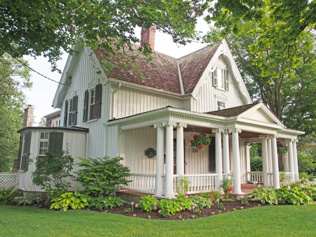
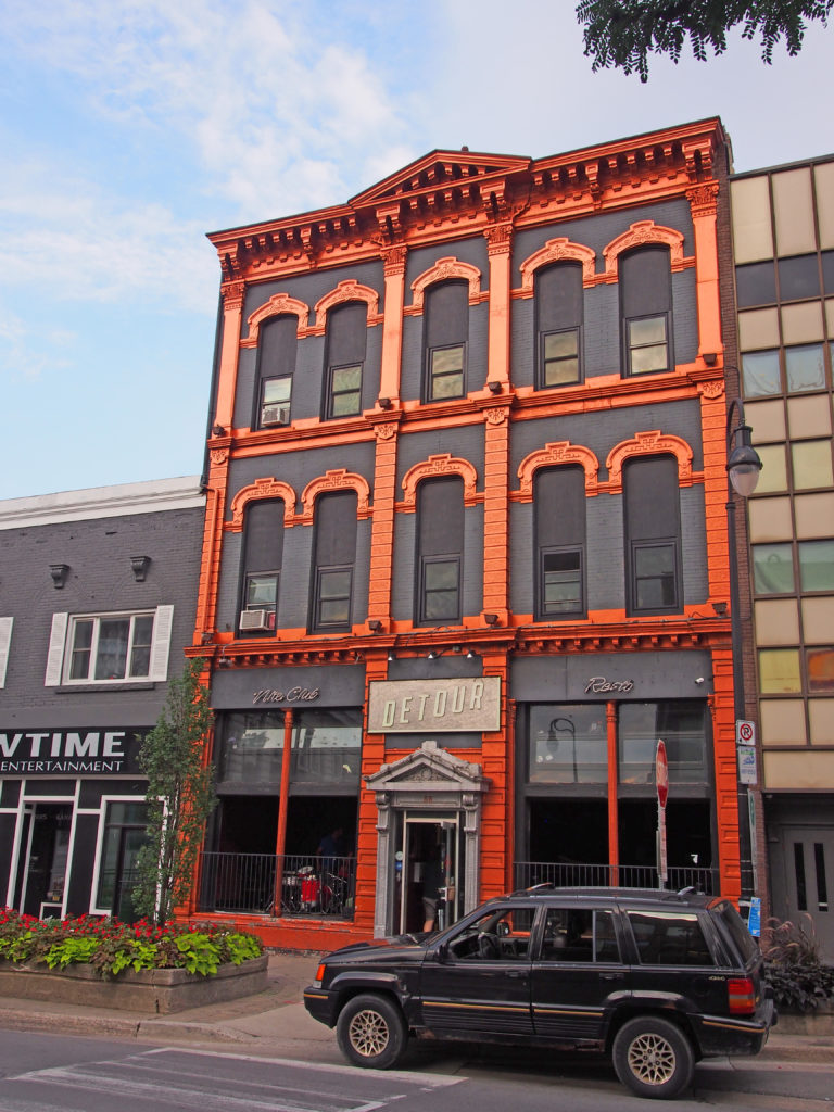
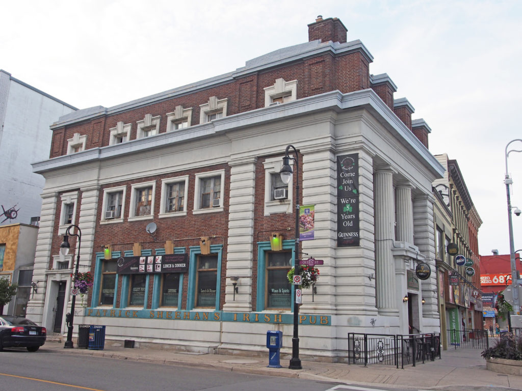
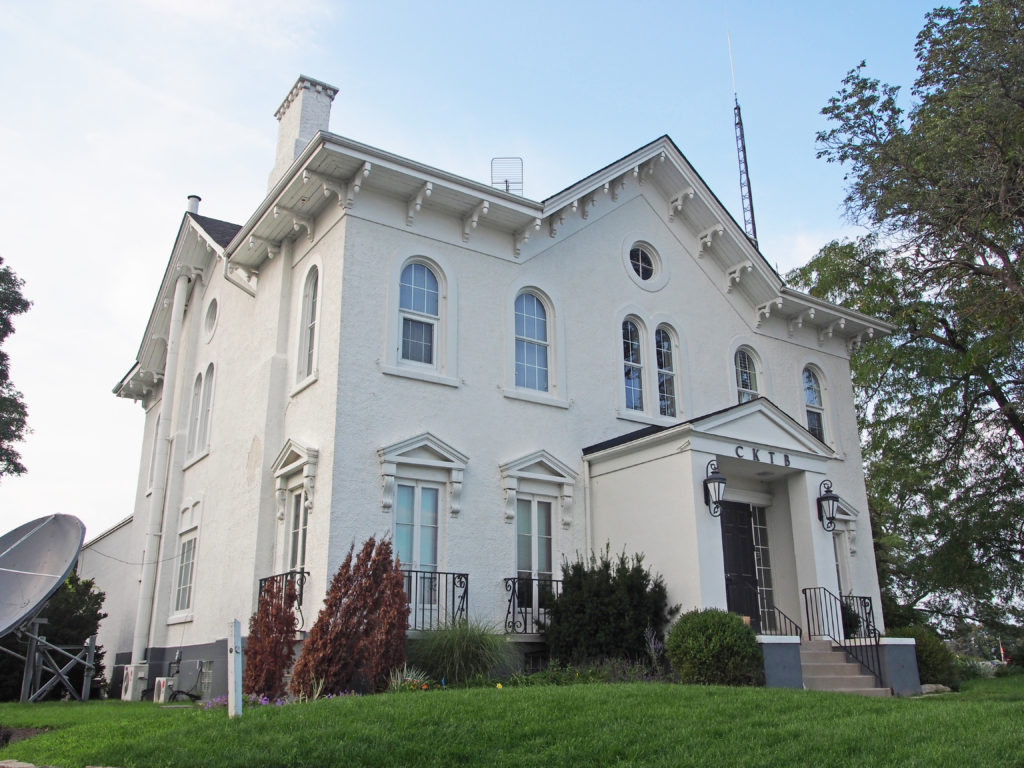
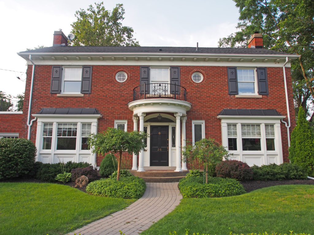
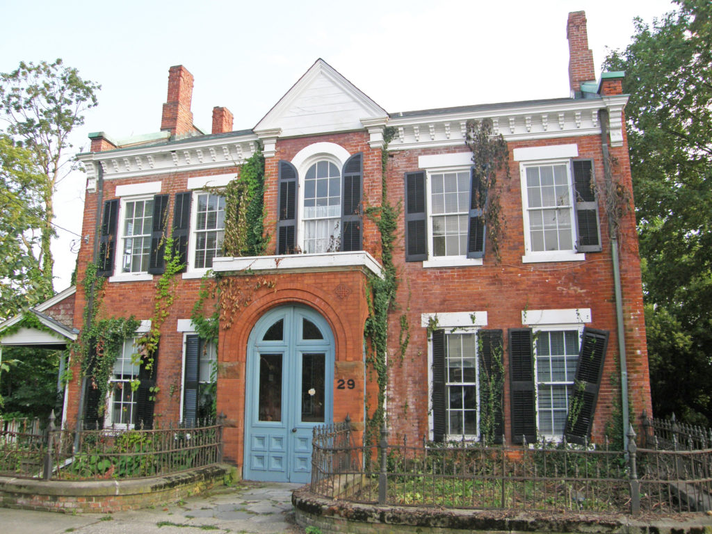
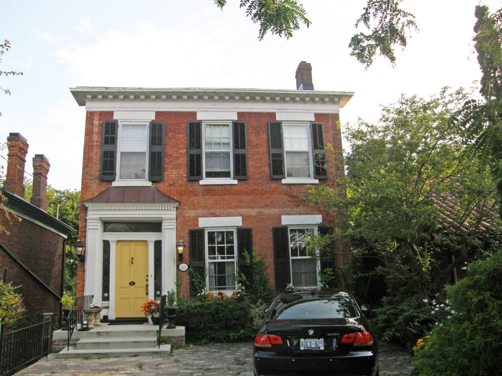
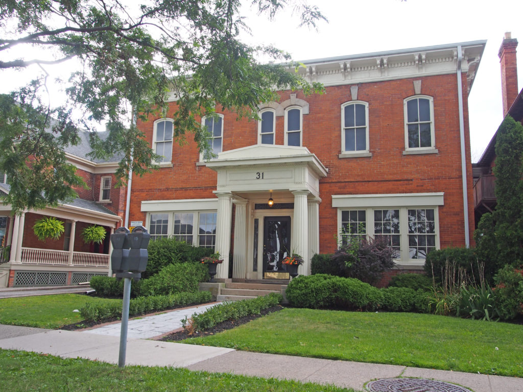
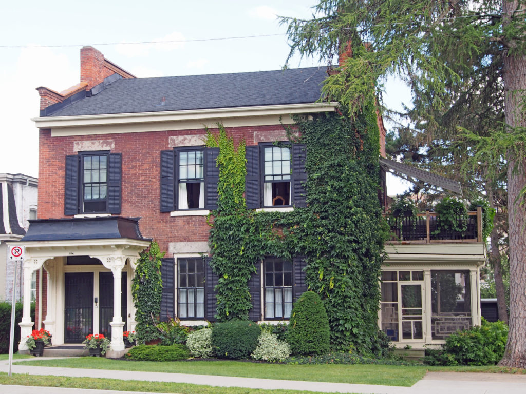
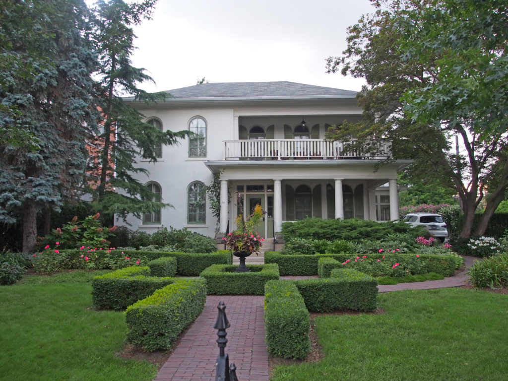
Court Street – 2½ storey tower, pediments on the roof, banding, beveled dentil molding, semi-circular stone voussoirs19 Centre Street – Edwardian – oval stained-glass window with contrasting-colored brick voussoirs87 Queen Street – Gothic, pediment88 St. Paul Street – Detour Music Hall – pediment, cornice brackets, pilasters with composite capitals115 St. Paul Street – cornice brackets, dentil molding, voussoirs and keystones101 St. Paul Street – Patrick Sheehan’s Irish Pub – parapet, keystones, engaged Doric pillars, pilasters157-159 St. Paul Street – dormers, drip molds with keystones220 St. Paul Street – stepped parapet – 1914 date stone, voussoirs, banding321 St. Paul Street – mansard roof with dormers, tower extending above roof line with iron cresting around widow’s walk, polychromatic tile work, keystones15 Welland Avenue – Second Empire – mansard roof with dormers with window hoods, three-storey tower, pediment, cornice brackets, voussoirs and keystones12 Yates Street – cornice brackets, round windows in gables, pedimented window hoods over lower windows, sidelights – Oak Hill was built in 1860 after Merritt’s first house burned due to arson. Merritt was part of The Refugee Slaves Friends Society. The tunnels under Oak Hill house connected it to the coach house and another to Twelve Mile Creek. There was plenty of space to hide escaping slaves, and it was an important stop on the Underground Railway. In 1938 the building was converted into CKTB radio station.26 Yates Street – Classical Revival – second floor semi-circular balcony above pillared porch with composite capitals, sidelights and transom29 Yates Street – Georgian – balanced façade, cornice brackets, shutters on six-over-six windows30 Yates Street – three dormers, second floor balcony above pillared entrance with sidelights, bay window33 Yates Street – hipped roof, cornice brackets, shutters, engaged pillars around door with sidelights and transom
St. Catharines is the largest city in Canada’s Niagara Region in Southern Ontario. It is 51 kilometers (32 miles) south of Toronto across Lake Ontario, and is 19 kilometers (12 miles) inland from the international boundary with the United States along the Niagara River. It is the northern entrance of the Welland Canal. St. Catharines carries the official nickname “The Garden City” due to its 1,000 acres of parks, gardens and trails.
Before this area was settled several Indian trails intersected here at a ford in Twelve Mile Creek. They were improved by early settlers and a church was erected at the crossroads by 1798. A tavern soon followed and a settlement began to grow. After the War of 1812, the community expanded largely through the efforts of William Hamilton Merritt. He was the chief promoter of the first Welland Canal built in 1824-33. The canal made St. Catharines a center for water transportation, and provided abundant water power for industry. Factories and mills were established and St. Catharines became a leading flour-milling and shipbuilding center.
Dr.
Lucius Oille was born in 1830 and was one of St. Catharines most prominent
citizens. He served as a member of council for several years before becoming
mayor in 1878. He was the second mayor of the city and first chairman of the
waterworks. Oille was a physician and owned the first x-ray machine in St.
Catharine. He was involved in dozens of city projects, such as the organization
of the Niagara Central Railway and the city’s first streetcar system. In 1878
Dr. Oille donated a fountain in front of the courthouse at the corner of King
and James Street to the citizens of St. Catharines. He wanted to provide water
to citizens who were shopping in the market square or had come downtown to
work. Tin drinking cups were attached to the fountain by a chain so that people
could use them to drink. Dr. Oille even thought of the animals as the fountain
has a small basin at the bottom specifically for them. This gift marked the
establishment of the city’s waterworks system in 1875-1876. Dr. Lucius Oille
died on August 15, 1903.
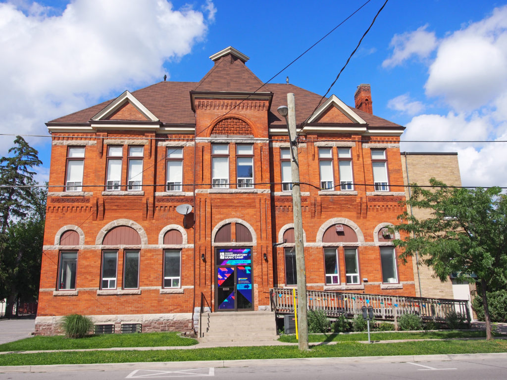
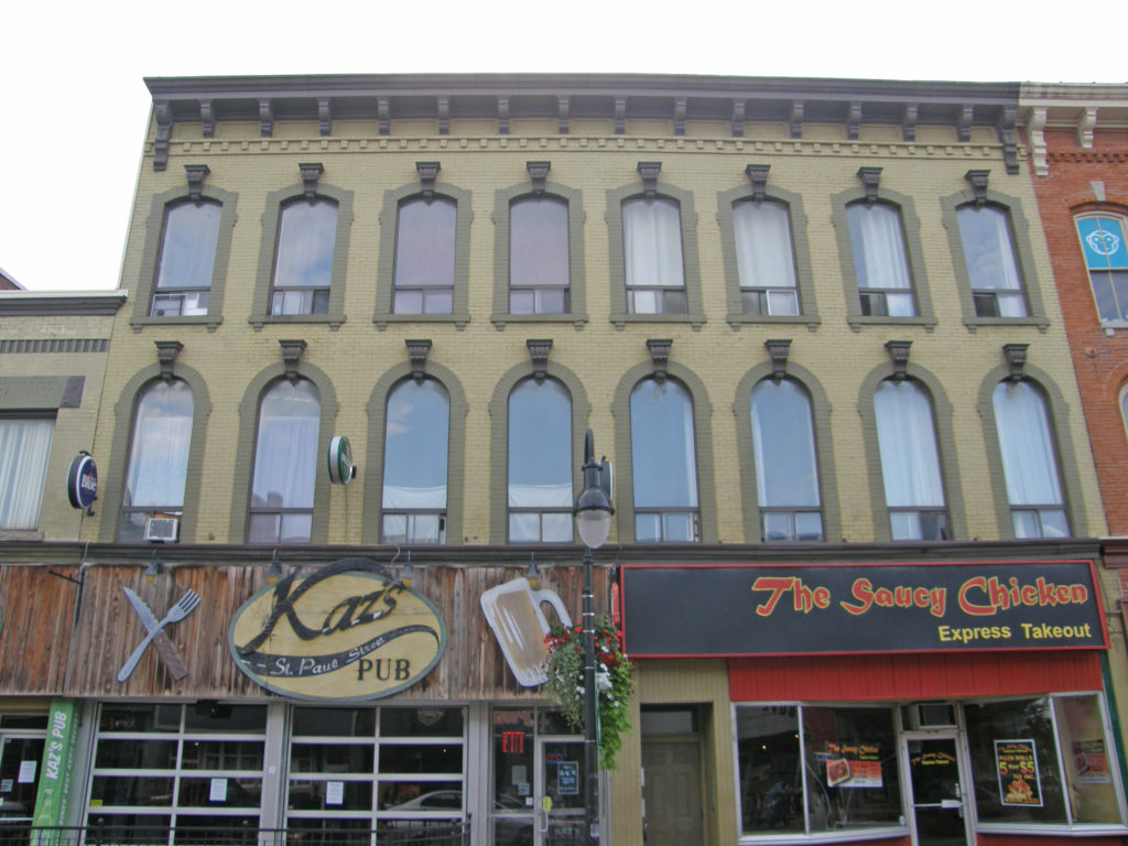
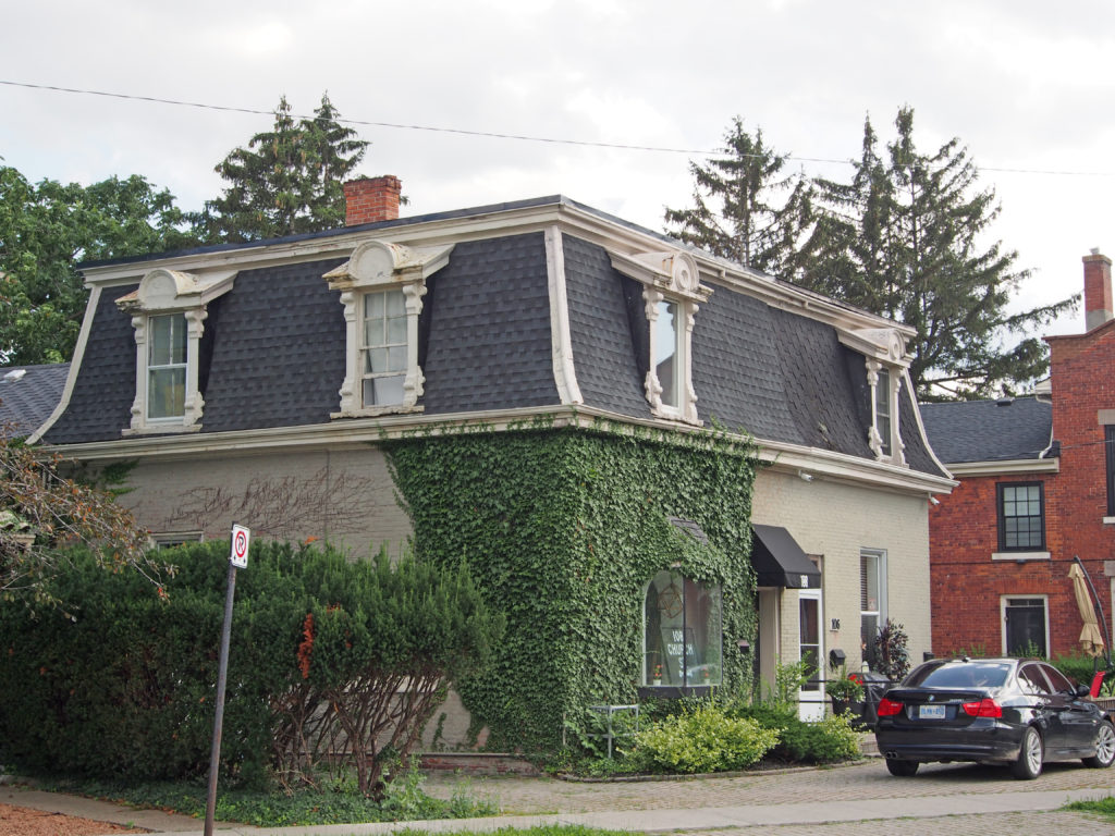
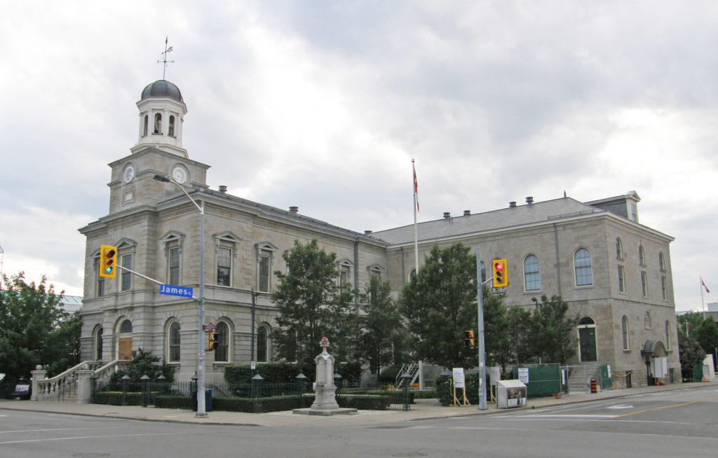
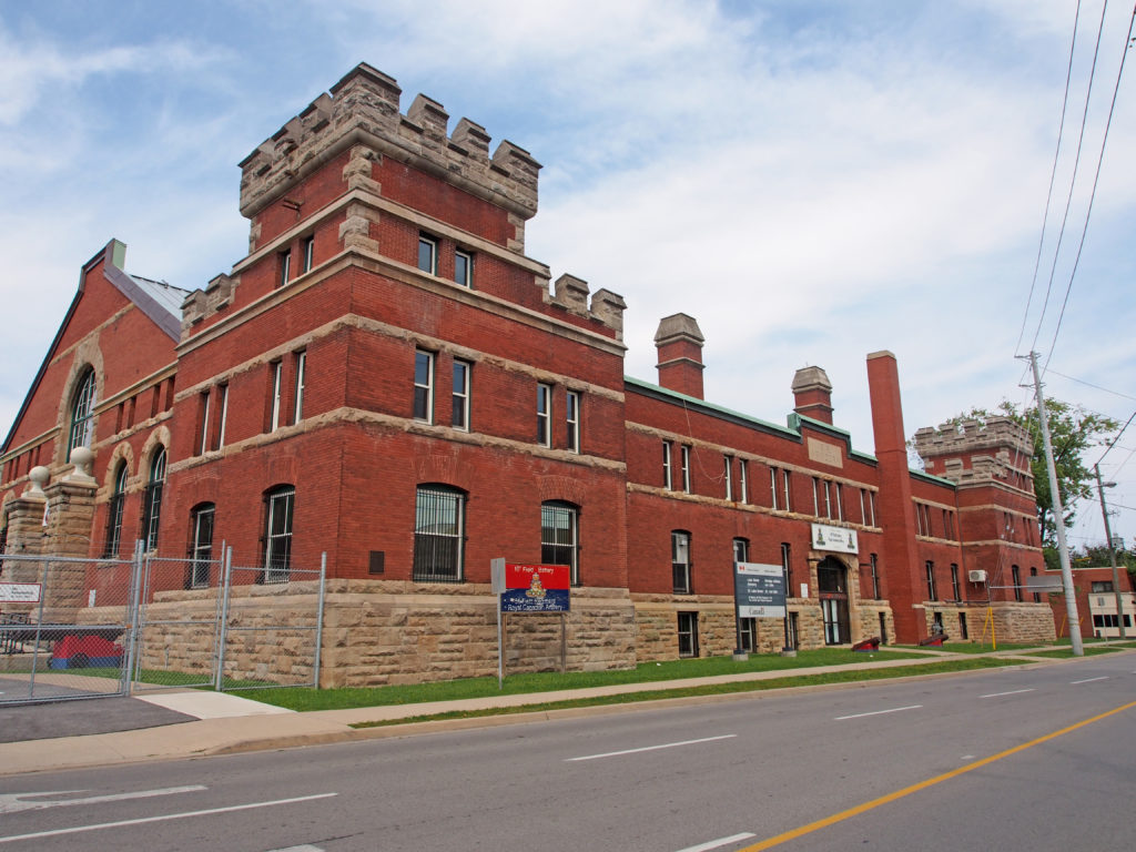
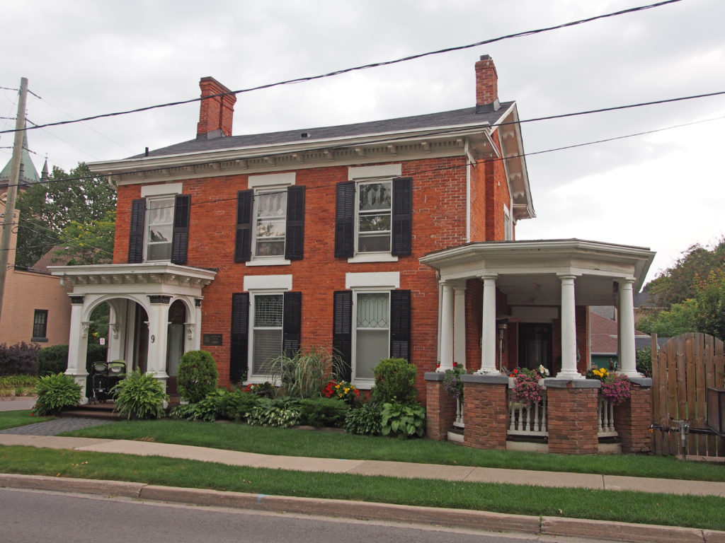
15 Church Street – 1½ storey frontispiece entrance – Heritage Building27 Church Street – Italianate – 2½ storey bay windows, fretwork, dormer26-30 Church Street – Gothic Revival, verge board trim and finials on gables31 Church Street – cornice brackets, dentil molding, keystones and voussoirs, free standing and engaged columns, sidelights and transom windows around door104 Church Street – decorative entrance, shutters on windows106-108 Church Street – Second Empire style, mansard roof, dormers with window hoods101 King Street – former Court House – Georgian style – 1848-1849 – The visible James and King Street facades are of channeled Queenston ashlars while the concealed west and north walls are constructed with a course rubble limestone and brick, respectively. The front façade has a tower with a three-faced striking clock and is topped by an octagonal cupola. The clock continues to chime with the assistance of the original weights which extend from the clock tower to the first floor. The entrance to the building is carved in stone like the town hall in Perugia, Italy. It features upright balustrades which conform to the slope of the stairway. The supporting columns under the copings on each side are individually carved to fit its specific location. The northeast wing cut-stone addition to the original structure was built in 1865 to accommodate the County offices and courthouse.164 King Street – three storey tower with voussoirs and keystones; cornice brackets183 King Street – Mill Memorial Home was built in 1868 for James Mills, a founding member of the YMCA. The structure is a two and one half storey brick home built with Italianate design influences. It features a central tower and decorative roof line brackets. The tower has a mansard roof and semi-circular dormers. There are oval windows set between two courses of white brick which are located below the boxed cornice, decorative frieze and brackets of the roof line. The main floor windows are segmental with plain trim and a continuous stone sill. The upper windows are set in semi-circular frames. The main doorway has a fan transom and a paneled door. The large veranda, supported by sets of wooden columns, stretches across the entire front façade; it is a later addition to the house.81 Lake Street – The Armoury was constructed in 1905 and was designed to serve as the regimental headquarters of the local militia and continues to function as a drill hall. It was from The Armoury that local militia units left to go overseas in 1914 and 1939, and for peacekeeping duties. The bulky, rectangular shape of the armoury is relieved by an irregular roof line and the stylistic diversity of its two basic constituencies. The expansive gable roof and the rhythmic course of arched windows marking the drill hall contrast with the crenelated towers, jutting chimneys, and rigorous fenestration patterns of the street elevations. The use of consistent materials and continuous horizontal elements unifies the overall composition. Quarry faced stonework is juxtaposed with fields of flat brickwork which accentuate the visual links afforded by the massive foundations, string courses and copings. The interplay of colors and textures inherent on the masonry is an essential feature.Lake Street – wraparound veranda, bay window127-129 Lake Street – dormers, finials and verge board on gables, beveled dentil molding, voussoirs and keystones72 Lake Street – dormers, cornice brackets, string course, voussoirs and keystones, two-storey bay window, rectangular bay window on side, bric-a-brac on veranda, sidelights and transom76 Lake Street – Italianate style, verge board trim on gables, voussoirs and keystones, bay windows, transom windows1 Montebello Place – Queen Anne style – varied roof line, turret, wraparound veranda on two levels, Palladian windows in gables, dormers10 Norris Place – 1874 – Norris Place in St. Catharines, Ontario is named after Captain James Norris who was a sea captain, businessman, Mayor of St Catharines and Member of Parliament. James Norris, one of the successful business men and leading manufacturers of St. Catharines, was born in Argyleshire, Scotland, in February 1820. At age fourteen, immigrated with his family to Upper Canada. When he was nineteen or twenty years of age, he came to St. Catharines, sailing on the lakes and Welland Canal in the season of navigation.9 Norris Place – Mr. Norris owned this place. Decorative entrance, octagonal veranda135 Ontario Street – fretwork, two storey bay windows, pediment