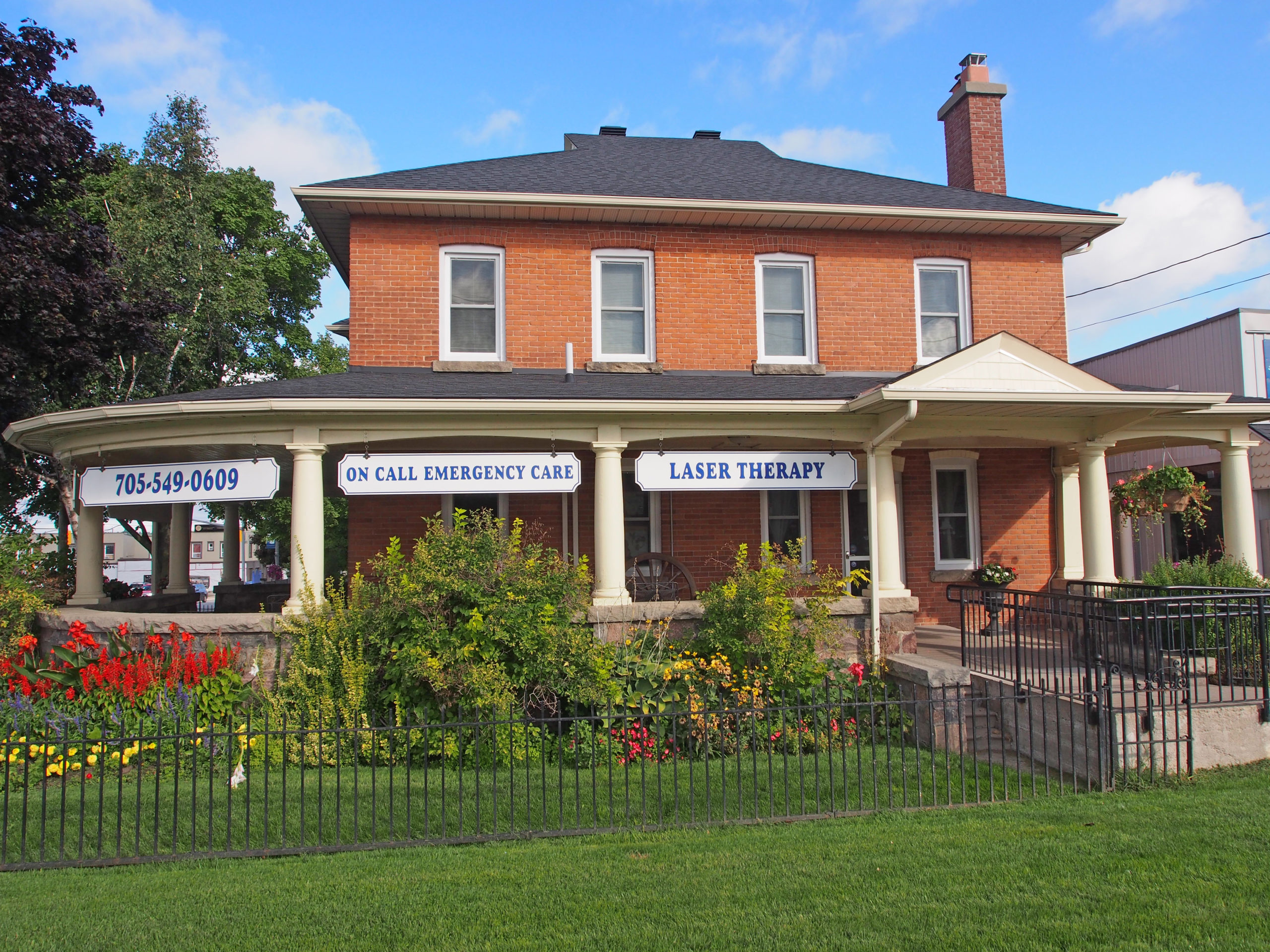
Kemptville is a community located in south eastern Ontario in the northernmost part of the United Counties of Leeds and Grenville and is about fifty-six kilometers south of Ottawa. Kemptville Creek begins southwest of the town, divides Kemptville, and flows four kilometers to empty into the Rideau River. Kemptville is composed of forests and farmland. The name Kemptville was adopted in 1829 as a tribute to Sir James Kempt, the Governor of British North America.
In 1812, Lyman Clothier bought one hundred acres of land from John Byce for the price of a yoke of oxen, and a flintlock rifle. Mr. Clothier had lived in the area since 1804 or 1805, and in 1812 he and his four sons built a saw mill, and two houses in what is now Kemptville. The mill was important for the settling of the community; in order to construct a crude dwelling, lumber was required. The mill provided lumber for settlers throughout Oxford Township.
The village was located on the Ottawa-Prescott Road and many travelers passed through the settlement. Â One of Mr. Clothier’s sons, Asa, opened his home to these travelers as a resting and meeting place. The “Clothier’s Hotel” was born. A grist mill was added in 1821 when the Clothiers placed some grinding stones in the lower part of their saw mill. Rather than taking their grain to a site on the St. Lawrence River, a daunting hike in the best of conditions, the settlers could now take it to this grist mill. A blacksmith’s shop was built and run by the Clothiers. A schoolhouse was built in 1823 and served the surrounding communities for many years. The first doctor arrived in the community in 1824. A weekly newspaper is published in Kemptville, called the Kemptville Advance, and has been published since 1855.
Elizabethtown-Kitley is a township in eastern Ontario in the United Counties of Leeds and Grenville. Its southern border lies along the St. Lawrence River and it extends north into many rural hamlets and villages. Also in the township are Addison, Forthton, and Newbliss.
Newbliss was settled mostly by Loyalists or immigrants from the British Isles who received their land here as grants from the Crown. One of the first businesses to operate here was Dack’s Tavern, built in 1817 and established as a tavern around the 1830s. The tavern had five rooms, three bed and horse stables, and also hosted Orange Lodge meetings. By the mid-1800s, the village began to flourish when roads improved in the area. By this time, the settlement consisted of two hotels, a blacksmith shop, a wagon shop, a general store, a post office, and its own schoolhouse. A cheese factory consisting of three buildings operated from Newbliss. The main building was later turned into the general store.
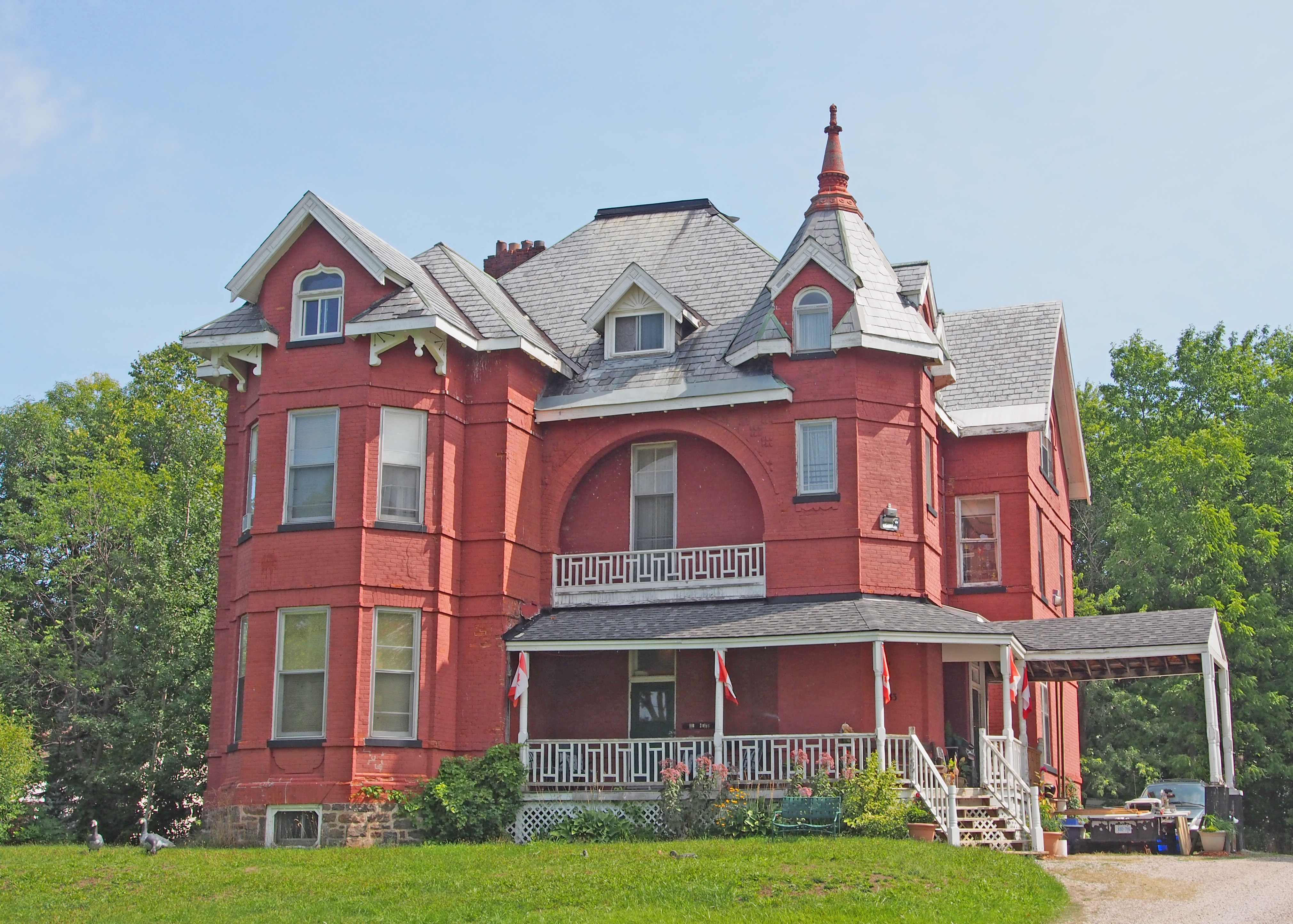
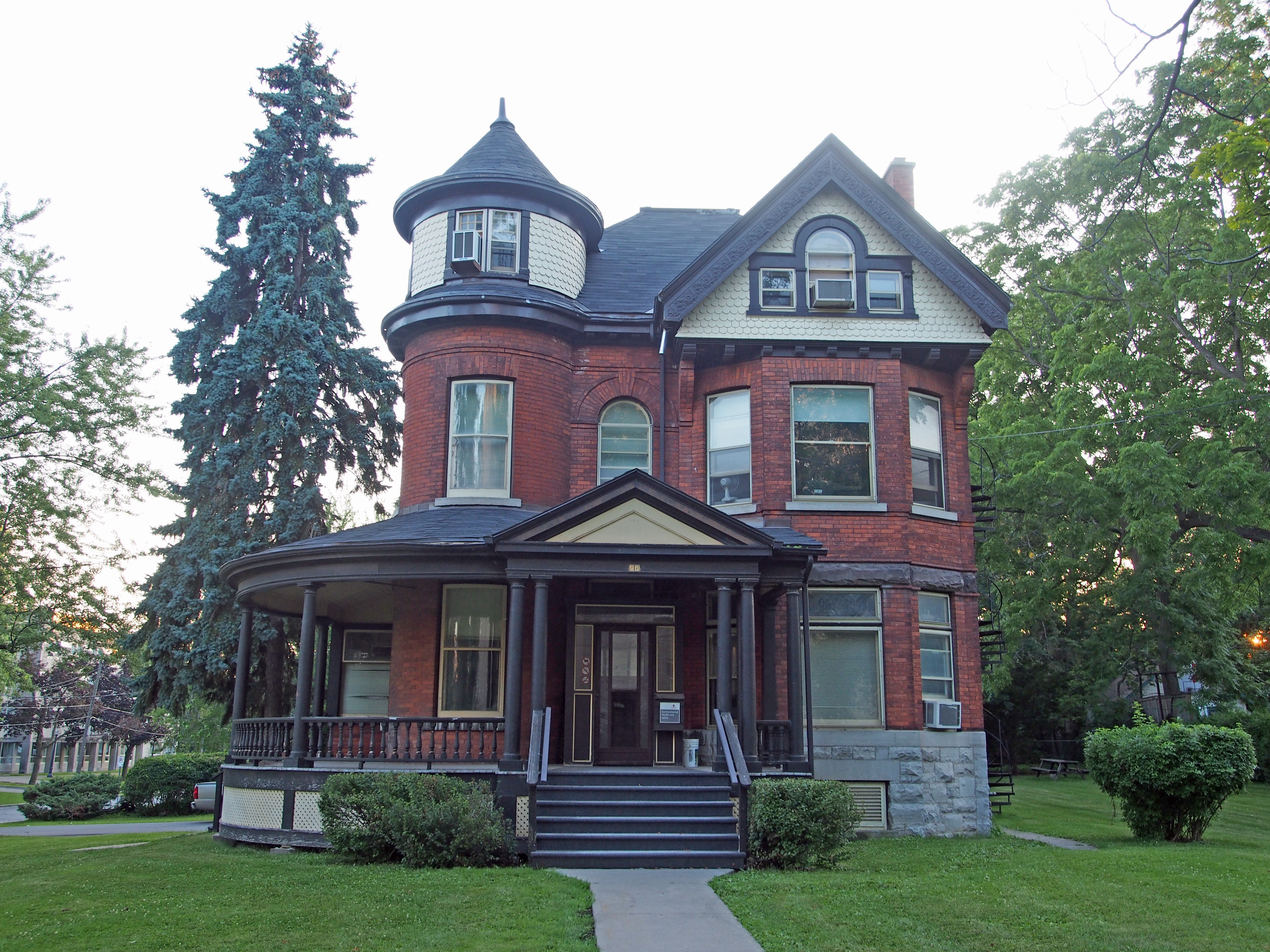
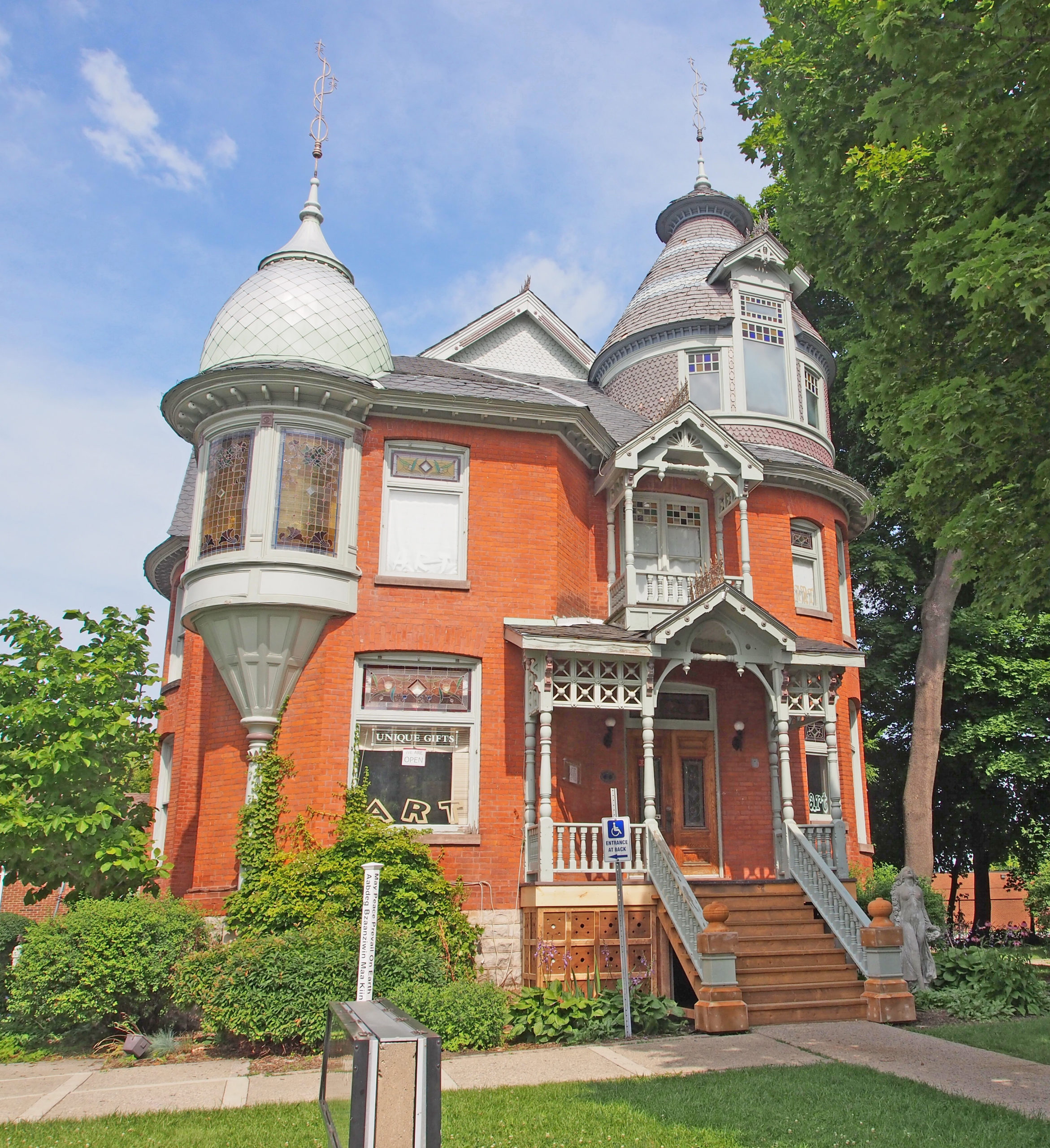
220-222 Prescott Street – de Pencier House – 1897- brick – Queen Anne style – tower, turret, iron cresting
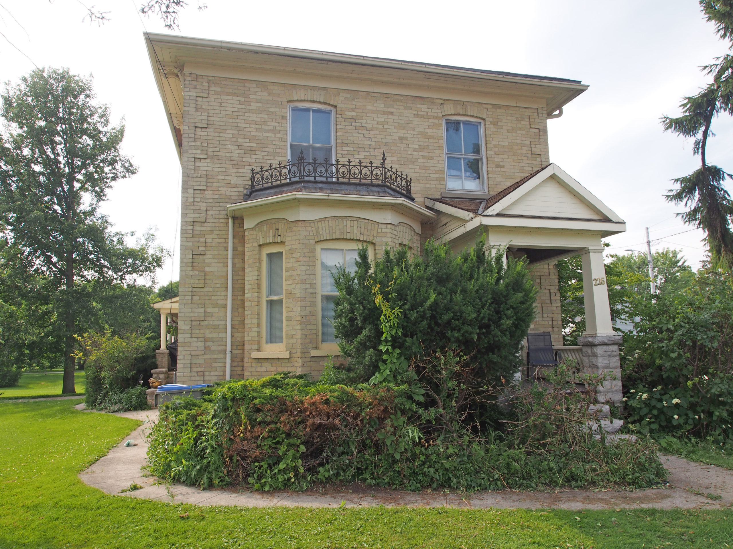
216-218 Prescott Street – 1897 – Queen Anne style – towers, dormer
Â
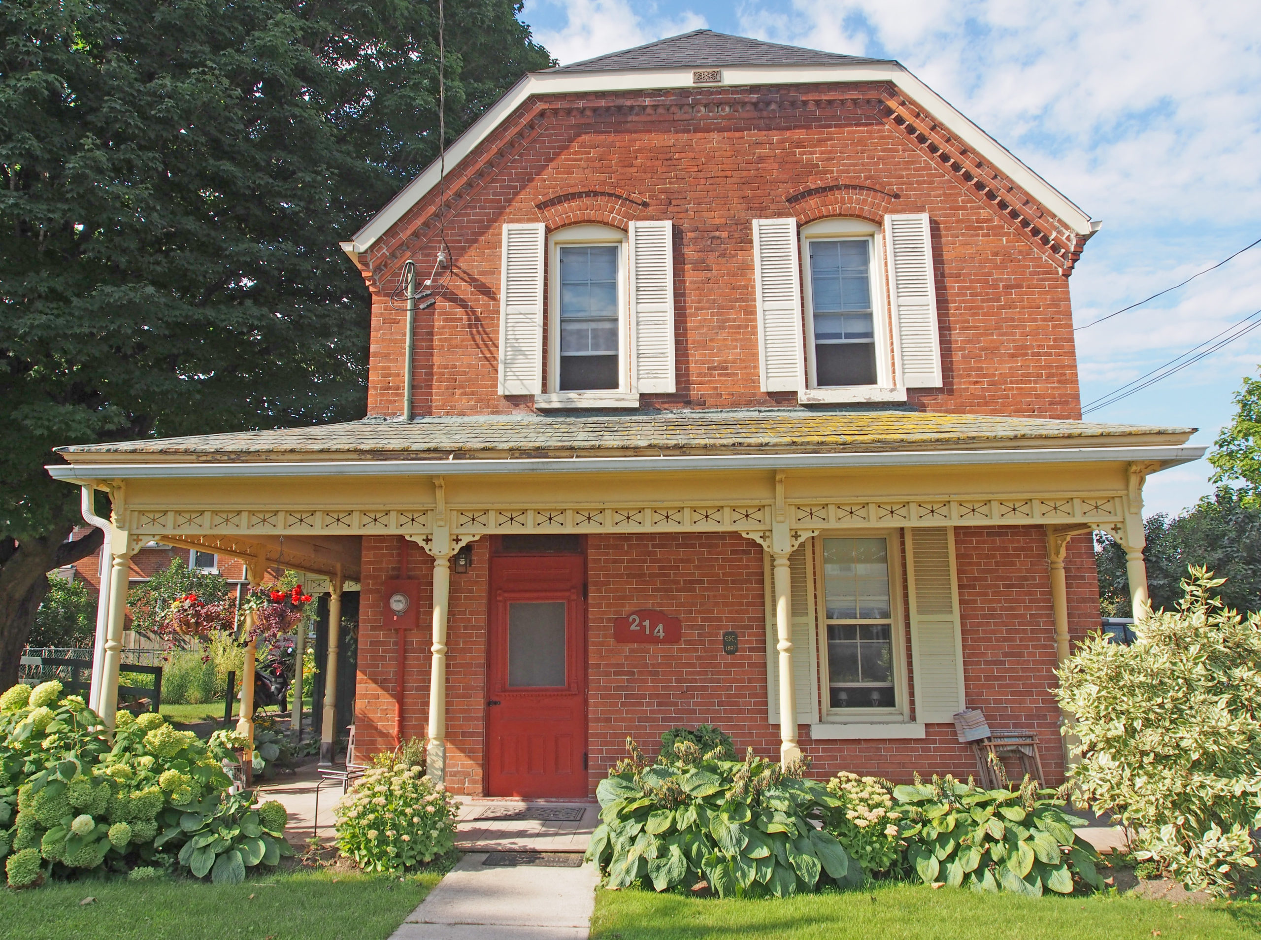
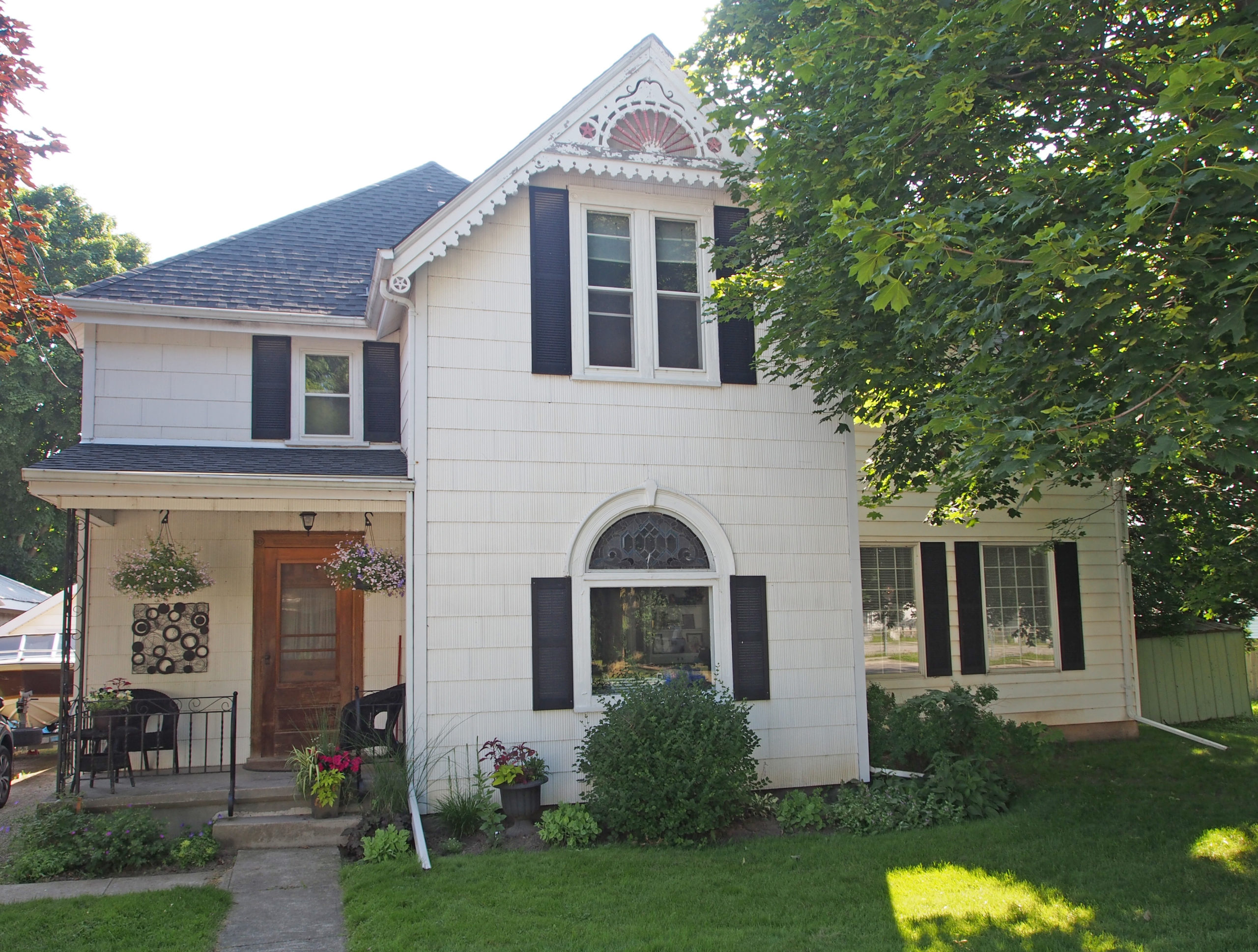
214 Prescott Street – 1897 – decorative brickwork under cornice; open wooden veranda with decorative railings and support postsOpen wooden verandas on both levels with decorative support posts and open railingsAddison – Italianate – hipped roof, cornice brackets, corner quoins, pedimentToledo – Gothic Revival – verge board trim on gables, painted corner quoins and voussoirs
Penetanguishene, sometimes shortened to Penetang, is a town on the southeasterly tip of Georgian Bay. It is a bilingual, French and English, community. The name means “land of the white rolling sands”.
As early as 800 A.D., the Huron settled in semi-permanent villages in the area. The young French translator, Etienne Brule, was the first European to set foot in the Penetanguishene area between 1610 and 1614.
In 1793, John Graves Simcoe, the first Lieutenant Governor of Upper Canada, visited the area and saw the location’s potential as a naval base. He wanted to use the bay to shelter warships to protect British interests on lakes Huron, Erie and Michigan. Beginning in 1814, the British-Canadians built the Penetanguishene Road to provide the area a land route to Barrie and Toronto, as it was previously accessible only by water transport along the rivers or across Georgian Bay. In 1828, the main British military establishment on the Upper Lakes moved from Drummond Island to Penetanguishene. Families of Metis fur traders who had moved with the British from Michilimackinac to Drummond Island after the War of 1812, moved again to Penetanguishene. The trip from Drummond Island took from fourteen to eighteen days and the bateaux were extremely crowded as they often carried eighteen people along with provisions and household goods. Although the naval base was closed in 1834, the military base remained until 1856. Some of the troops settled in the area after their service was complete providing an English-speaking population.
In the 1840s, French-speaking families from Quebec (mainly from the area immediately east of Montreal), attracted by promises of cheap and fertile land, joined the French-speaking settlers already in the area. Later, as the logging industry began to develop, more English-speaking settlers arrived.
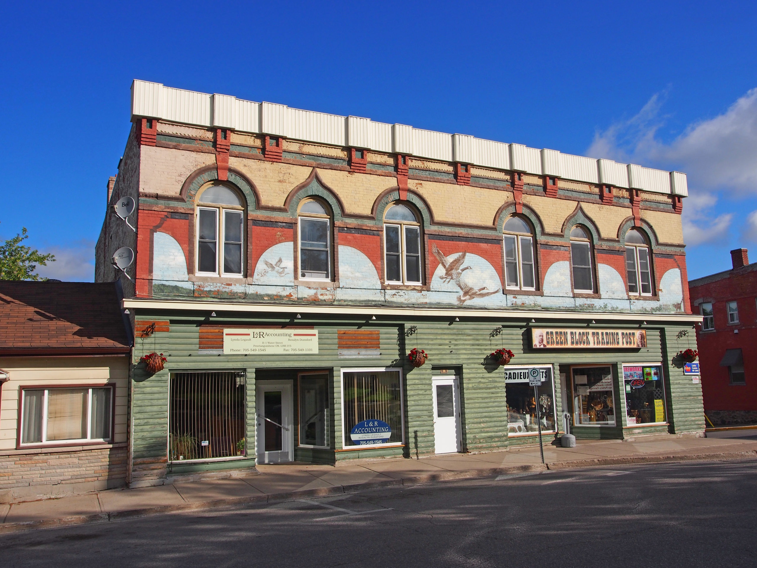
Alfred Andrew Thompson came to Penetanguishene in 1830 at the age of 15 to work as an assistant to Andrew Mitchell, Sr., a fur trader on Water Street. In 1840, Alfred erected a mercantile store on the corner of Water and Main Streets known as the Green Block. It was the only market in the area where farmers could sell their produce of butter, eggs, and vegetables for cash to pay their taxes. In 1847, Alfred married Sarah Anne Burke and they had three sons and two daughters. Alfred was an Anglican involved in the affairs of St. James-on-the-Line Church.
Michael Gendron, born in Quebec of French parents, came here in 1835 and established a tannery on the banks of Copeland’s Creek, and later a second tannery on Main Street. “Gendron Penetangs†were a type of moccasin made of hand-stretched, oil-tanned leather, sturdy enough to be used by lumberjacks, prospectors, hunters and surveyors. They were regulation issue for soldiers in World War I.
Joseph Dubeau and his family came to the area in 1859; he started a livery stable and moved families from Penetanguishene to Midland.
The C. Beck Manufacturing Company operated from 1875 to 1969 selling wholesale lumber, shingles, lath, pails, tubs and wooden ware to firms in Ontario, Quebec, western Canada and the northern United States.
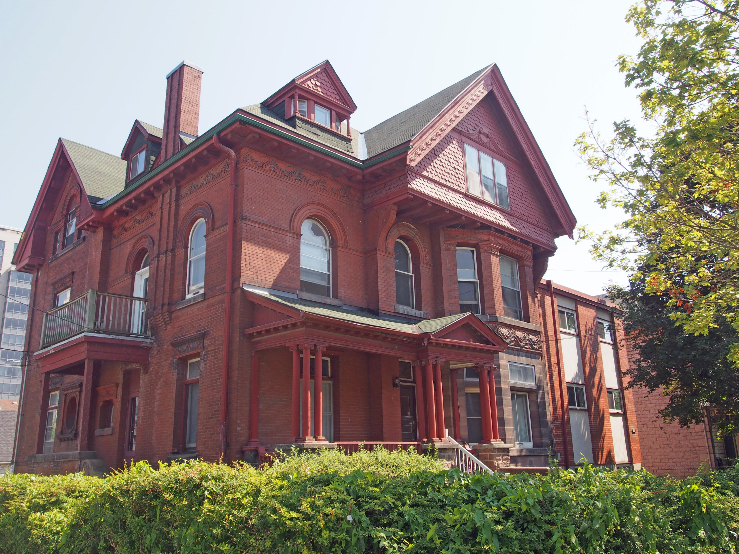
83 Fox Street – 1885 – home of Charles Beck and Amelia Dalms who had nine children (6 boys, 3 girls) – Queen Anne style – fretwork, turret, dormer, second-floor balcony, string courses wrap around the house; unique shape of window in gable
16 Peel Street – sidelights; pediment above dormer with keystone18 Maria Street – hipped roof with dormers, second floor balcony, corner quoins, multi-paned transom windows above large first story windows, open spindle railing69 Poyntz Street – 1905 – built by George Pelletier, a carpenter; rooftop balcony above dormer; fretwork; enclosed wraparound veranda33 Robert Street – J. T. Payette’s home (ran P. Payette Foundry – machine shop; built many mills)1 Water Street – The Green Block – built in 1840s by Alfred Andrew Thompson (he painted it green) for his mercantile business – now called Green Block Trading Post – voussoirs, keystones, Canada Geese mural131 Main Street – home of Charles E. Wright (butcher) – 1912 – Doric pillars on wraparound verandah, pediment, hipped roof143 Main Street – gambrel roof, Neo-colonial style3 Maria Street – Gothic – home of Frederick W. Jeffery (bookkeeper) – 1878 – steeply pitched gable roof, verge board trim on gables, two-story bay window, dormer
Midland is located on the southern end of Georgian Bay’s 30,000 Islands about ninety miles north of Toronto.
Huronia was named for the Huron Nation and consists of the areas around southeastern Georgian Bay which include Midland and Penetanguishene. The area was visited by French Jesuits traveling with the Voyageurs to the Wye River in 1639. They were welcomed by the Huron tribe who traded furs and skins for metal goods and clothing from France. They built a settlement named Fort Ste. Marie which thrived for ten years until it was burned to the ground in 1649 by the Jesuits themselves after repeated attacks from Iroquois who were in league with the English who wanted the French share of the fur trade in North America. Some of the priests were martyred. The Sainte-Marie among the Hurons site was discovered in 1947, excavated and rebuilt to its original form by archeologists from the University of Western Ontario.
The Jesuits attempted a second site on St. Joseph’s Island, currently Christian Island, and named it Sainte Marie II. They carried many of their goods by raft to this second site. After a winter of terrible hardship and starvation, the Jesuits decided to abandon their mission and returned to Quebec in 1650. Christian Island was later declared a native reservation by the Canadian government.
In 1871 a group of the principal shareholders of the Midland Railway, headed by Adolph Hugel, chose this location as the northern terminus of their line which they ran from Port Hope to Beaverton. The town site was surveyed in 1872-73. The railway line was completed in 1879 and soon attracted settlers to the area. The new community, Midland, achieved its early growth through shipping and the lumber and grain trade.
In and around the center of Midland there are a number of murals most of which were painted by now deceased artist Fred Lenz.
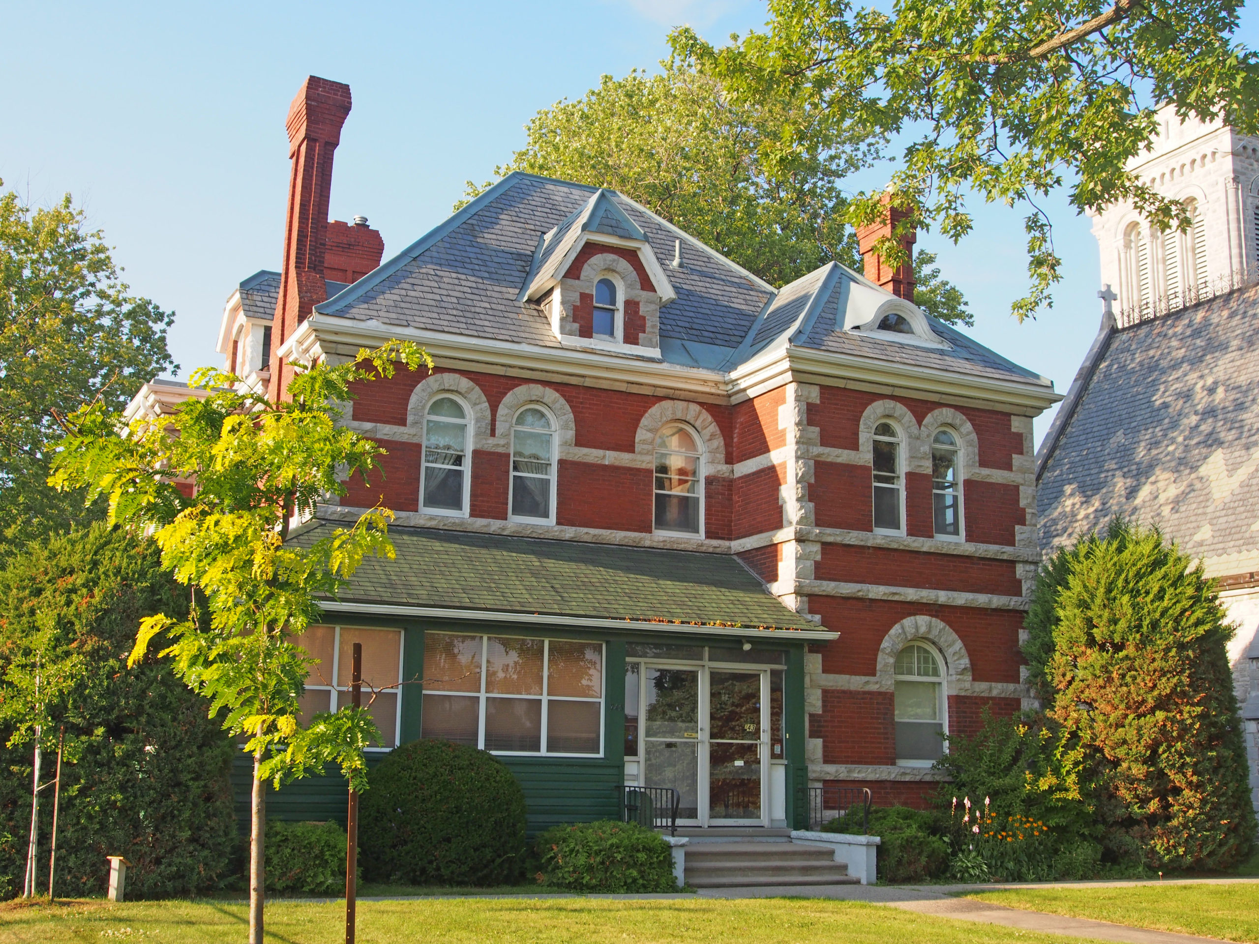
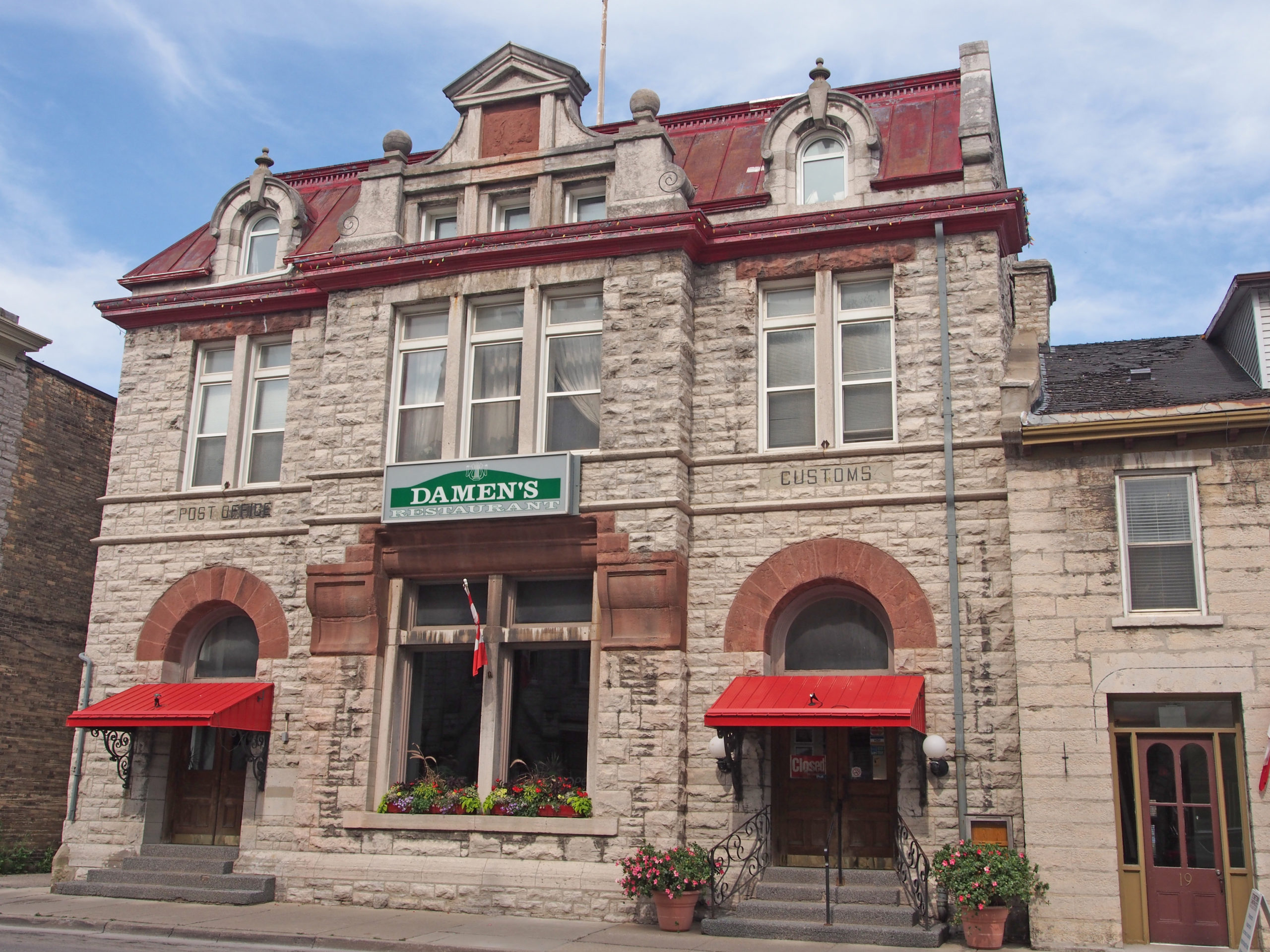
320 King Street – The impressive Romanesque style limestone structure which now houses the library was built in 1913 as Midland’s first post office, with customs and excise offices on the second floor. – mansard roof, high central gable, imposing corner porch, and tower; 2½ storey building composed of even course cut stone, with a belt course that goes around the entire building; metal roof has a decorative stone fascia; some semi-elliptical windows, and a corner entrance. In 1963 the post office, needing more space, moved to its new home on Dominion Avenue and the beautiful limestone building sat empty for three years. In 1967, the library moved to the old post office. Setting your watch by the clock tower would be inadvisable as the four faces do not always agree. – Midland Book 1
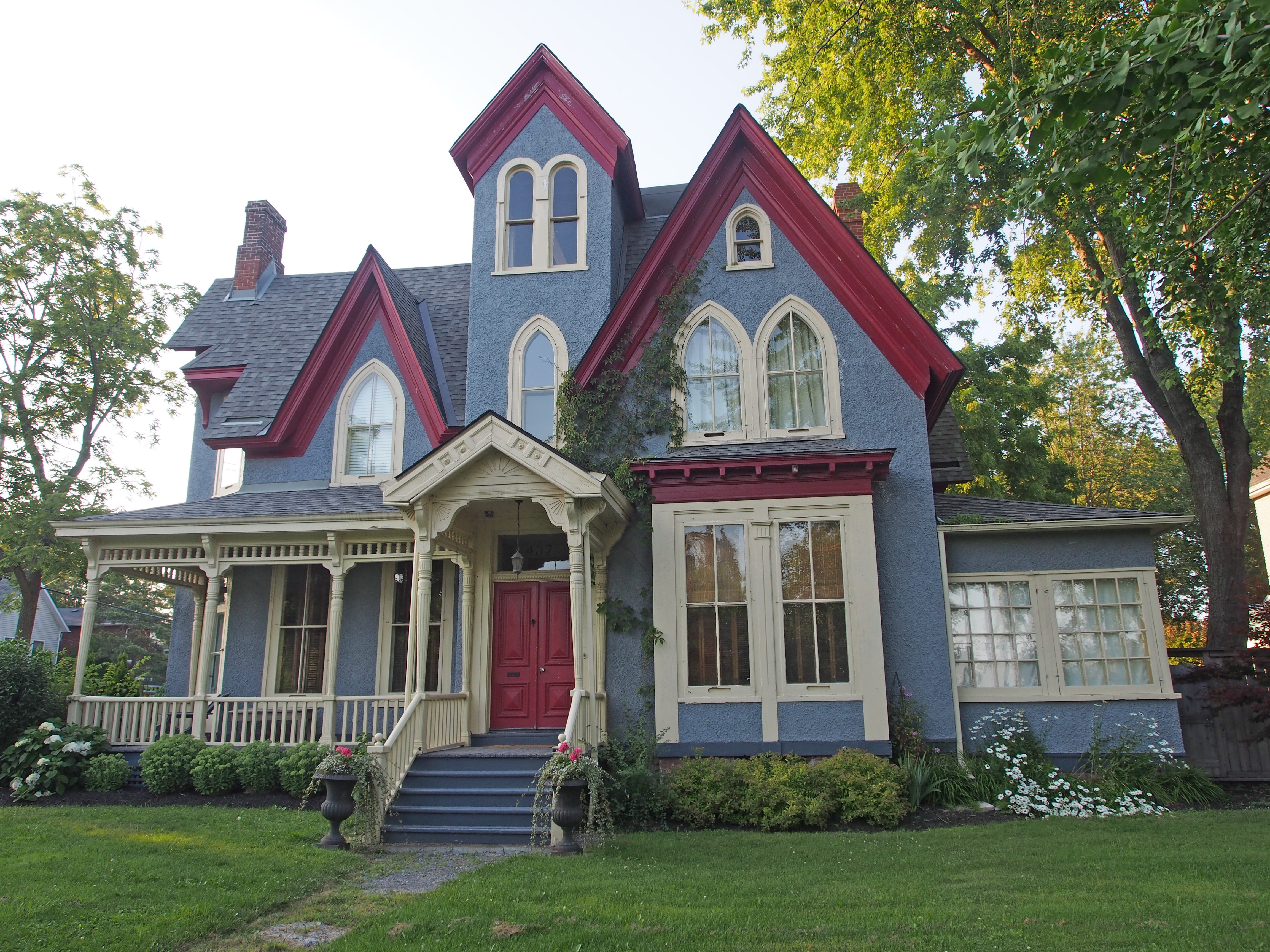
234-236 King Street – Jeffery Block – 1901 – Romanesque Revival style – large number and regular rhythm of windows; extend brick corner quoins and varied brick courses on the window lintels – The Crow’s Nest Pub and Restaurant is now where the hardware store was; second floor YMCA; top floor Odd Fellows lodge meeting rooms203-207 King Street – two-story, flat roofed commercial building – Burton Block, built by the Burton Brothers of Barrie – exterior of the building is made up of board and batten, stretcher brick, poured concrete, and sheet metal siding; frontispiece and decorated panels; brick keystones above windows; blind transom above door. The original stone carvings of Greek gods are still intact above the Taxi Stand door.213-219 King Street – Second Empire – mansard roof, dormers, dichromatic brickwork437 King Street – exterior is stretcher brick with a cut stone foundation; medium hipped roof and two second story balconies; brick voussoirs; decorative brick below some windows; sidelights; open verandah with open railings and wood piers431 King Street – full basement; low gable roof with a double gable on the facade with a molded fascia; exterior is finished with log; main entrance has an ogee shaped opening with a plain pediment roof above and wood piers on sides414 King Street – late 1800s – 2½ story brick, Gothic Revival – dichromatic brick patterns, roof gables and dormer with rounded roof, various window shapes and sizes, mixed design verge boards and verandas409 King Street – Palladian window in gable roofed dormer; two-story bay window; second floor balcony above closed in porch; varied roof line318 Third Street – 1900 – Victorian – irregular layout; medium gabled roof; double gable on facade; fascia and soffit are molded metal; exterior is stretcher brick and vertical plank board; two balconies; brick voussoirs; 4-over-4 window panes; blind transom; open porch with wood posts and pediment – Midland Book 270 Fifth Street – built 1900, square layout and a wing on the left side; exterior is stretcher brick; upper story balcony; medium hipped roof has an offset gable end on the facade and a molded frieze; semi-elliptical window on the left; open wooden veranda with decorative railings and support posts613 Dominion Avenue – built in 1900 – Vernacular – irregular layout and several different types of roofs, including flat, medium gable, and medium hipped, a decorated fascia; exterior is stretcher brick and poured concrete; upper story balcony; windows with brick voussoirs; transom window; open platform veranda with decorated open railing and decorative trim along the roof line; wood piers to support the roof695 Dominion Avenue – built 1890, exterior of panel wood, broken course cut stone, stretcher brick, and terracotta; medium gable roof, with decorated fascia and several gable ends with half timbering and gabled dormers; brick voussoirs; bay window on second story; open veranda with open railing, stone, support pedestals, and Ionic capitals 657 Hugel Avenue – The Dollar House is the former residence of two of Midland’s leading historical figures: James Dollar and William Finlayson (lawyer, cabinet minister). Decorative gable ends, bracket roof trim, bay windows; medium hipped roof with several gables and gable roofed dormers; window voussoirs; two chimneys423 Hugel Avenue – The Captain’s House Heritage Bed and Breakfast – built 1900 – Edwardian Classicism style, low gabled roof, siding and brick facade, numerous windows and a stone foundation; large bay window401 Manly Street – 2½ stories; stretcher brick and wood shingle exterior; pyramidal roof with two cross gables; two balconies with open railings and decorative supports; brick voussoirs; Palladian windows in gables; wraparound veranda with stone supports, decorative piers, and open railings
After the union of the two Canadas in 1841, Kingston, Montreal, Toronto and Quebec were in succession the seat of government. During the 1850s these cities contended for designation as the permanent capital of Canada. During Queen Victoria’s long reign, the nation of Canada was created, grew and flourished. Queen Victoria ascended the throne in 1837, the same year that violent rebellions broke out in Upper and Lower Canada with demands for a more democratic and responsible form of government. These rebellions prompted many reforms, including the unification of Upper and Lower Canada into the Province of Canada. In 1857, Queen Victoria chose Ottawa as Canada’s capital, a political compromise as well as a more secure distance from the American border. In 1867, Queen Victoria signed the British North America Act to create the Dominion of Canada, a self-governing nation within the British Empire, established through peaceful accord and negotiation. The Fathers of Confederation reaffirmed the choice and Ottawa as the capital for the new Dominion.
Parliament Hill sits at the heart of Canada’s Capital, overlooking a river that reflects many histories. From the beginning, Parliament Hill was designed as a workplace for parliamentarians, and also as a place where everyone could come to meet, talk or just relax in a beautiful outdoor setting. Today there is a scenic promenade which follows the shoreline of the Ottawa River.
The Centre, East and West blocks of the Parliament Buildings were built between 1859 and 1866 (excluding the Tower and Library). The Parliament Buildings have vaulted ceilings, marble floors and dramatic lighting which create an air of dignity. The stone walls have a lot of decoration.
Sir John A. Macdonald (1815-1891) was one of the driving forces behind Confederation in Canada, with Nova Scotia, New Brunswick, Ontario and Quebec joining together to form a new country. Macdonald served as the country’s first prime minister. Manitoba, British Columbia and Prince Edward Island entered Confederation under his government, while the last spike of the Canadian Pacific Railway’s transcontinental line was hammered into the ground.
The Rideau Canal, a great military engineering achievement of the nineteenth century, was completed in 1832 and opened central Canada to settlement and trade. The canal was planned after the War of 1812 to provide a safe way to transport troops and equipment between Montreal and Kingston. The entrance locks mark the beginning of a 202-kilometer route linking the Ottawa River and Lake Ontario through a system of lakes and rivers connected and made navigable by the channels, locks and dams that the workers constructed.
In the 1890s, when Prime Minister Sir Wilfrid Laurier spoke of making Ottawa a “Washington of the Northâ€, he wanted a new architectural style for the Capital that was distinct from American and older British models, in pursuit of grandeur.
In 1982, the Queen and the Right Honourable Pierre Trudeau, Prime Minister, signed the Constitution Act, 1982 to make Canada an independent nation.
Parliament Hill – Centre Block with Peace Tower – Ottawa Book 1
1 Rideau Street – Fairmont Chateau Laurier, one of Canada’s landmark railway hotels, built in the Canadian Chateau style
555 Mackenzie Avenue – The Connaught Building – 1913 – Tudor Gothic – named after the Duke of Connaught, third son of Queen Victoria, who served as 10th Governor General of Canada from 1911–16 – faced in rusticated sandstone, embellished with turrets, a crenellated roofline, buttresses, corbelling, niches, carved embellishments, an ogee arched entrance and rows of flat-headed windows accented by dressed quoins
320 Chapel Street – Victorian – three-storey tower, cornice brackets, gable, voussoirs, banding, dormer, composite columns around door – Ottawa Book 4
In October 1783, at Carleton Island, Captain William Redford Carleton of the King’s Royal Regiment of New York, met with the local Mississauga Indians led by the elderly Mynass. Crawford, acting for the British government, purchased from the Mississaugas for some clothing, ammunition and colored cloth, a large tract of land east of the Bay of Quinte. In September 1783, Deputy Surveyor-General John Collins was dispatched to Cataraqui by Governor Haldimand to lay out townships for Loyalist settlers. By the end of the year, the front concessions of four townships stretching from Cataraqui to the Bay of Quinte had been surveyed. A fifth township was laid out the following summer. The land was subsequently settled by United Empire Loyalists and Britain’s allies who had been forced to leave their homes in the new United States.
Earl Street has a wide range of homes, some originally built for factory workers and others for the wealthy. They include a variety of frame, stone, stone and brick, and all-brick homes. They have different roof lines, porches, trim, chimneys, windows and transoms.
The Kingston Custom House was built 1856-59 for the government of the united Canadas. The symmetrical composition of the two-story ashlar building, surmounted by a restrained cornice and parapet, draws on the British classical tradition. The orderly design is achieved through repeated use of semi-circular forms for doors and windows. The Custom House and the nearby Post Office are fine examples of the architectural quality of mid-nineteenth century administrative buildings.
The Kingston Penitentiary which opened on June 1, 1835 was Canada’s oldest reformatory prison. Its layout – an imposing front gate leading to a cross-shaped cell block with workshops to the rear – was the model for other federal prisons for more than a century. It is Classical architecture in local stone.
Kingston Penitentiary represented a significant departure from the way society had dealt with its criminals. Previously, jails were used primarily as places to hold convicts awaiting execution, banishment, or public humiliation. The penitentiary imposed a severe regime designed to reform the inmate through reflection, hard work, and the fear of punishment. Inmates lived in small cells but worked together from dawn to dusk under a rigidly enforced code of silence. Kingston Penitentiary stands as a symbol of this country’s commitment to maintaining law and order.
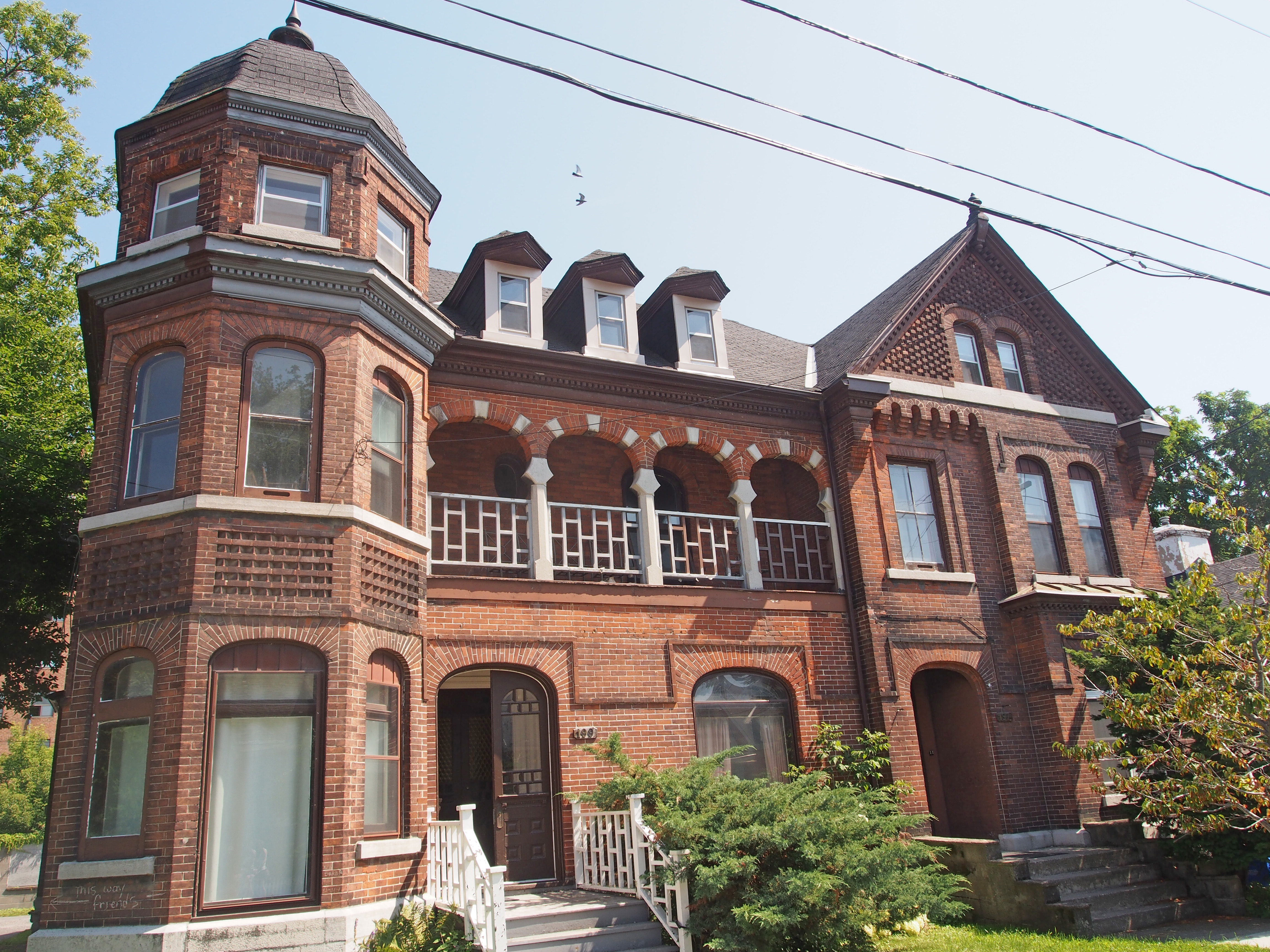
197-199 King Street East – Queen Anne – three-story turret, dormers, second floor sleeping balcony, dichromatic voussoirs, decorative brickwork in large gable
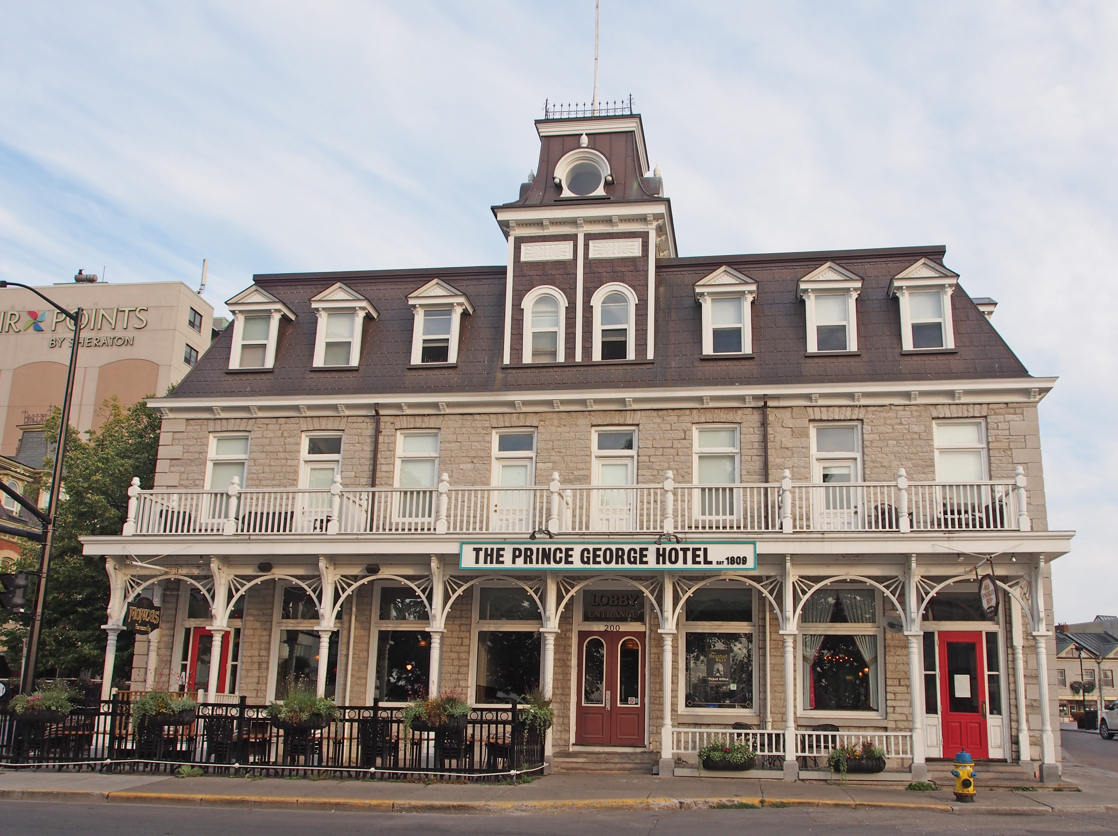
200 Ontario Street – The Prince George Hotel established 1809 – the facade is actually three separate buildings – the middle part is a stone house built about 1817; new stores were built on each side of the house in 1847 – later became a hotel – third floor with mansard roof added in 1892; iron cresting on the tower; copper roof; decorative woodwork on verandah – Kingston Book 2
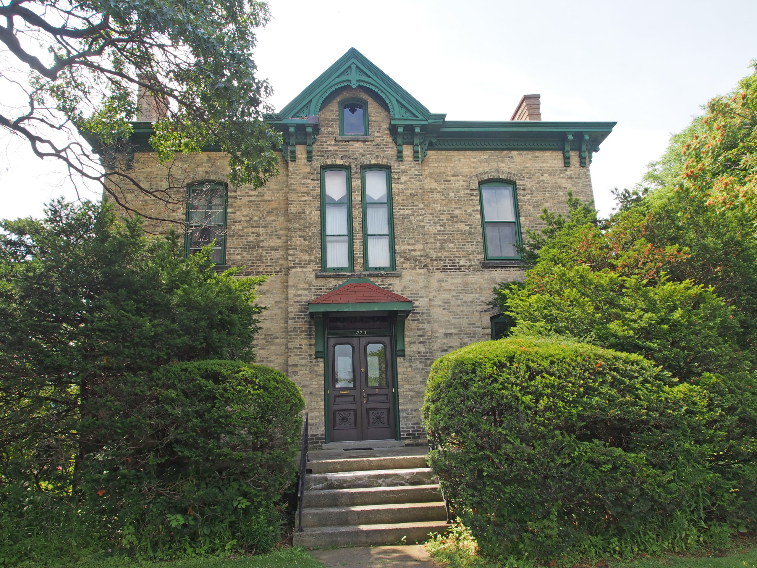
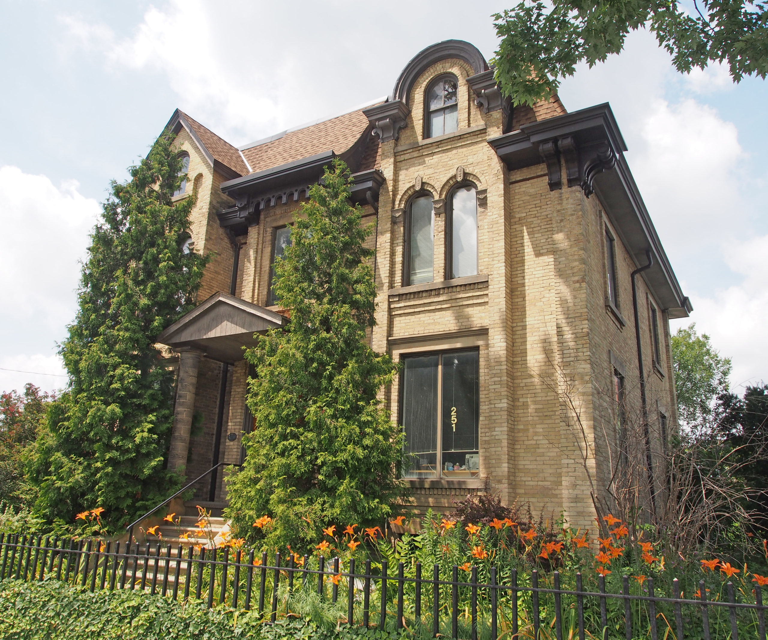
251 Brock Street – Elizabeth Cottage – Gothic Revival style – built 1840s – steeply pointed gables, projecting bays, oriel windows – accentuate play of light and shadow on smooth stucco walls; applied Gothic decorative details such as verge board trim, crockets, finials and drip moldings heighten the picturesque effect
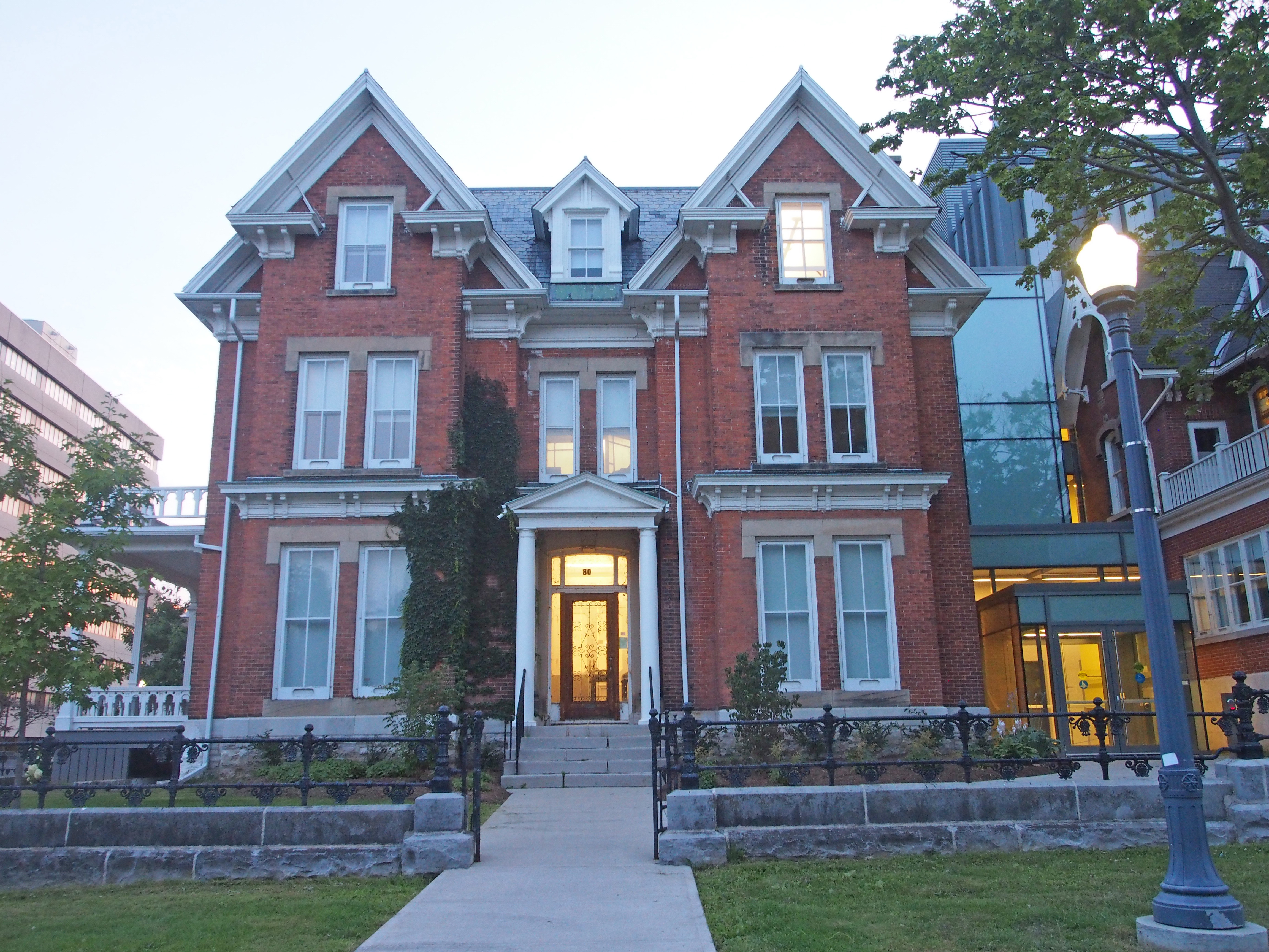
80 Barrie Street – Italianate – 2½-storey tower-like bays, cornice return on gables, dormer between gables, cornice brackets, pediment above door, sidelights and transom – Kingston Book 3
24 Sydenham Street – Hochelaga Inn – a French Victorian mansion built in 1879 by John McIntyre and his wife Harriet, who was a relative of Sir John A. Macdonald – transformed into an inn in 1985 – three-story tower, cornice brackets, bay window
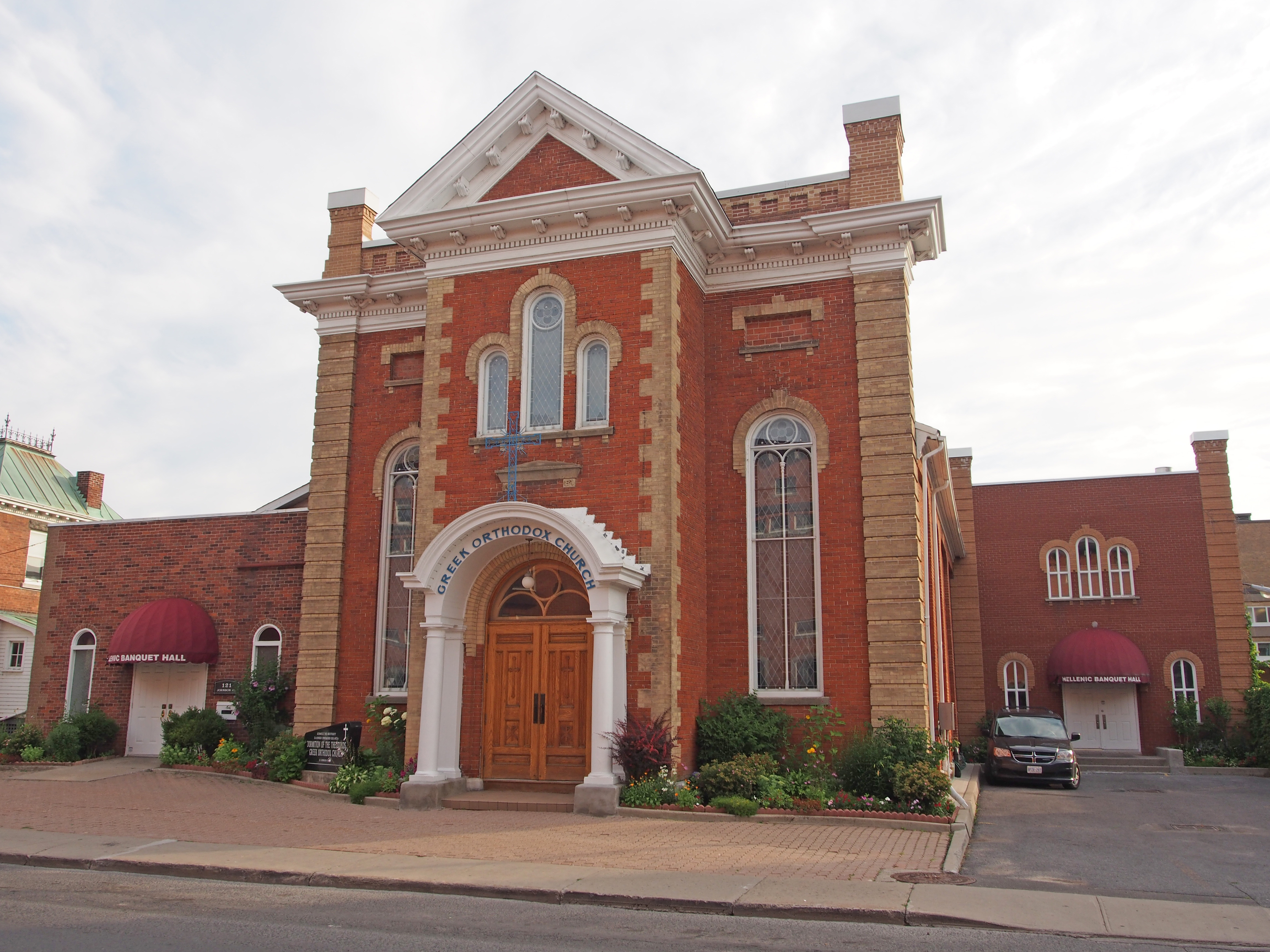
121 Johnson Street – Greek Orthodox Church – Romanesque style – two-story frontispiece topped with pediment, corner quoins, dentil molding
Johnson Street – Second Empire style – 2½ story, Mansard roof, dormers, iron cresting on roof, wraparound verandah
96 Albert Street – Queen Anne style, three-story turret, Palladian window above two-story bay window, pediment, voussoirs with keystone – Kingston Book 5
King Street West – two-story tower, lancet and semi-circular windows, transom window above door – Kingston Book 6
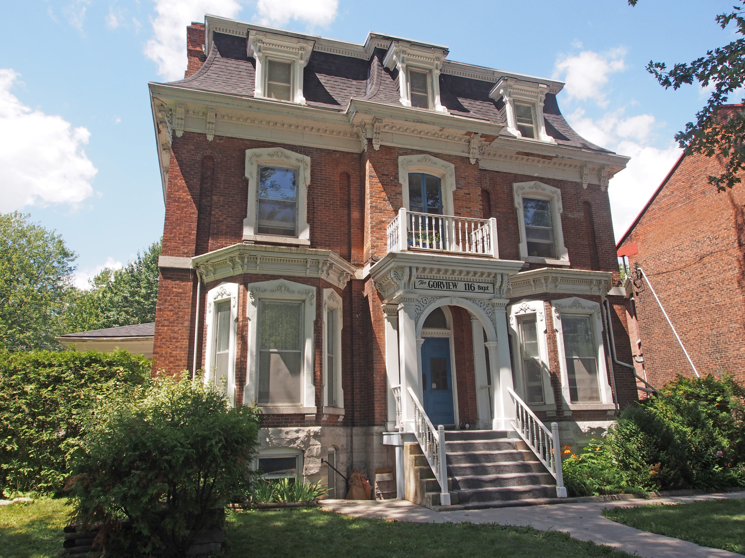
213 King Street East – Italianate – decorative brickwork below cornice and above first floor windows, dormers with fish scale pattern in the gables, pediment, columns with Ionic capitals supporting the verandah – Kingston Book 1169 King Street East – designed in 1885 by William Newlands for banker Donald Fraser – three-bay, two-story house is built on a high foundation; porch with paired columns on brick piers and a plain balustrade was added later; corner quoins with raised panels; channeled hood52 Earl Street – built by William Henry Smith in 1876 – Grove House – sunburst design on the facade; cornice brackets, oriel window, dormers12 Wellington Street – Second Empire, mansard roof, dormers with window hoods, two-story central verandahs – Doric columns on first story with semi-circular arch with keystone; Ionic columns on second story with identical arch743 King Street West – Romanesque style, voussoirs and banding, gabled dormer, eyebrow dormer, tall chimneys, corner quoins – Kingston Book 4222 Johnson Street; 226 Johnson Street – Mansard-like roof with dormers, semi-circular and rectangular windows208-210 Bagot Street – Edwardian, two-story tower-like bay, dormers110 Bagot Street – Tudor half-timbering style116 Bagot Street – Second Empire, Mansard roof with dormers and window hoods, second floor balcony, bay windows, cornice brackets, dentil molding, pillared entrance164 Queen Street – Gothic Revival – verge board trim on gables, corner quoins, and dichromatic brickwork462 King Street West – Stone Gables, 1924, part of the St. Helen’s Complex, is located on landscaped grounds bordering Lake Ontario. The grand, Tudor Revival, stone building features a steeply pitched gable roof, a projecting gabled frontispiece, prominent gable chimneys, and hipped dormer windows.163 Union Street – two stories, hipped roof with dormer, four Corinthian pillars supporting a semi-circular roof with balcony above, dentil molding, sidelights and transom windows around door169 Union Street – Mansard-type roof with dormers81 Lower Union Street – Gothic – 1½ story brick cottage built in 1875 – narrow sidelight windows, porch with Doric pillars – carved wooden barge board on gable, dormers
Welland is located in the center of Niagara. Within a half-hour, residents can travel to Niagara Falls, Niagara-on-the-Lake, St. Catharines, Port Colborne or Buffalo. It has been traditionally known as the place where rails and water meet, referring to the railways from Buffalo to Toronto and Southwestern Ontario, and the waterways of the Welland Canal and Welland River, which played a great role in the city’s development. The city is separated by the Welland River and Welland Canal which links Lake Erie and Lake Ontario.
The city was first settled in 1788 by United Empire Loyalists.
Welland, because of its proximity to the Sir Adam Beck hydroelectric station at Niagara Falls, was historically known for its steel, automotive, and textile industries. Manufacturing firms were the biggest employers in Welland, with companies like Union Carbide, United Steel, Plymouth Cordage Company, three drop forges, a cotton mill, and the Atlas Steel Company, as well as general manufacturing plants, influencing the shaping of early Welland.
The Plymouth Cordage Company was the first major industrial company to open a plant in Welland in 1906. It was a rope making company with headquarters in Plymouth, Massachusetts; it became the largest manufacturer of rope and twine in the world. Plymouth binder twine was popular among farmers to package farm crops such as grass, wheat and straw, and was the inspiration for the naming of the Plymouth brand of automobiles first produced in 1928. Many workers who relocated to Welland from the company’s operations in Plymouth were of Italian origin. To minimize the potential effects of cultural and language barriers, Plymouth Cordage sent four foremen to Welland: one was Italian, one was French, one was German and one was English.
131 Aqueduct Street – Bagar-Bison House – 1880 – Victorian – two-storey tower, pediment, fish scale pattern on upper storey, sidelights around door – Welland Book 1
30 Bald Street – Queen Anne style, two-storey turret with cone-shaped cap, second floor sleeping porch
24 Burgar Street – The Glasgow-Fortner House – 1859 – Queen Anne style – now Rinderlins Dining Rooms
204 East Main Street – Lawrence-Phillips House – c. 1890 – Victorian style with a mixture of Gothic, Tuscan Italianate and Queen Anne elements
195 East Main Street – Victorian style102 East Main Street – Welland County Court House – built in 1855-56, four years after the creation of Welland County; Neo-Classical style, built of Queenston limestone – the front of the building is dominated by a huge projecting portico surmounted by a classical pediment and four large Ionic columns, sidelights beside door28 Elgin Street East – Neo-colonial – gambrel roof, shed dormer124 Elgin Street West – Queen Anne style, decorative dormer with walkout balcony, two-story bay windowKing Street – Customs and Post Office – built 1901-02 – quoining, buttresses, dormers – Welland Book 2140 King Street – former Welland Public Library – 1923 – dark red Milton brick and Indiana limestone in the Beaux-Arts style123 Merritt Street West – Gothic, verge board trim on gable201 Niagara Street – Cooper Mansion – 1913-1914 – Renaissance Revival style, Jacobean gables (parapet), symmetrical facade with projecting wings, , dormers, stone trim, neoclassical doorway with elliptical fanlight and slender sidelights sheltered by a classical portico supported on six Doric columns71 Elgin Street East – Edwardian – Doric columns, dormer, Palladian-type window in gable
Petrolia is a town in Ontario twenty minutes from Sarnia, and fifty minutes from London.
Following the discovery of oil at Oil Springs in 1857, prospectors extended their search to the entire township of Enniskillen. At the site of Petrolia, which contained two small settlements with post offices named Durance and Ennis, a well was brought into production in 1860. The following year a small refinery was opened and the Durance Post Office renamed “Petroleaâ€. In 1865-66, the drilling of the King well established Petrolia as the major oil producing center in Canada and its population soared from about three hundred to two thousand three hundred.
Oil men from Petrolia traveled to the far reaches of the world (Gobi Desert, Arctic, Iran, Indonesia, the United States, Australia, Russia, and over eighty other countries) teaching others how to find and extract crude oil. Some oil fields in the area are still operational to this day.
Oil enticed people to come here, but Petrolia was created, nurtured, and sustained by hardworking visionaries, shopkeepers, builders, drillers, laborers, and leaders.
#430 – Italianate, hipped roof, corner quoins, iron cresting on roof (widow’s walk), paired cornice brackets
4200 Petrolia Line – The original Grand Trunk Railway Station was built in 1903. Designated heritage building now the Robert M. Nichol Library; turrets on each end, center tower
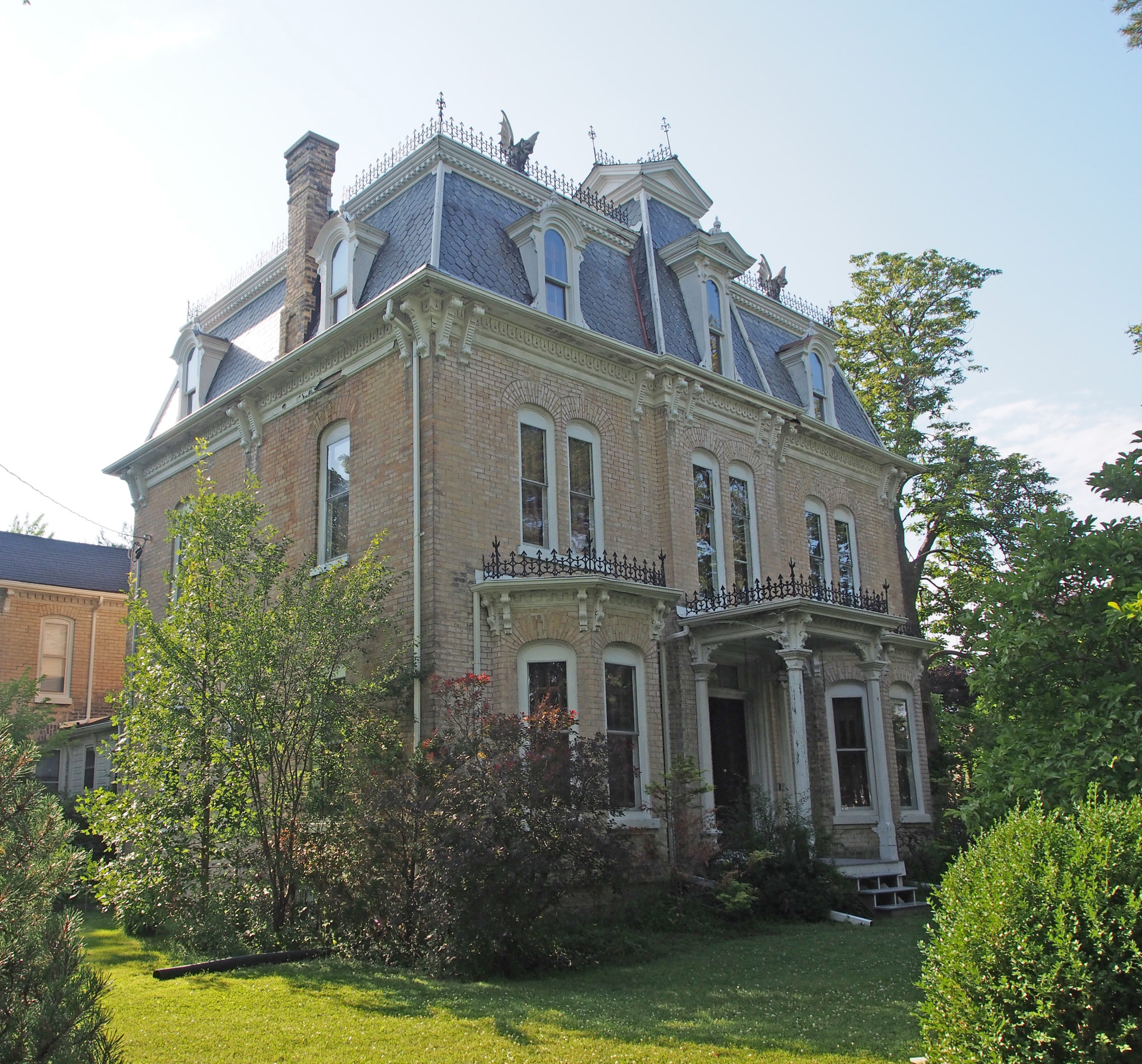
Petrolia Line – Romanesque, three-story turret, decorative iron railing on second floor balcony
Â
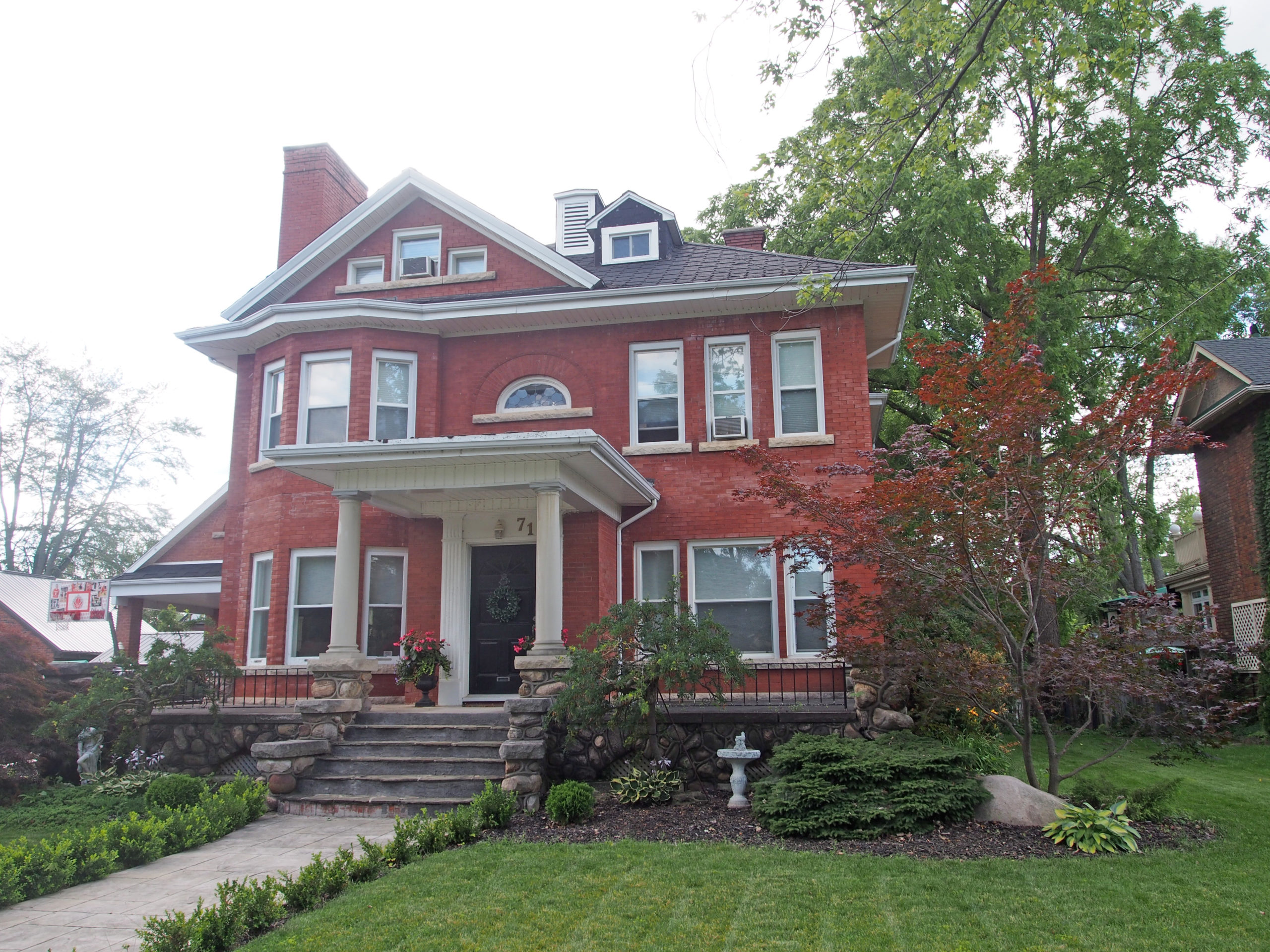
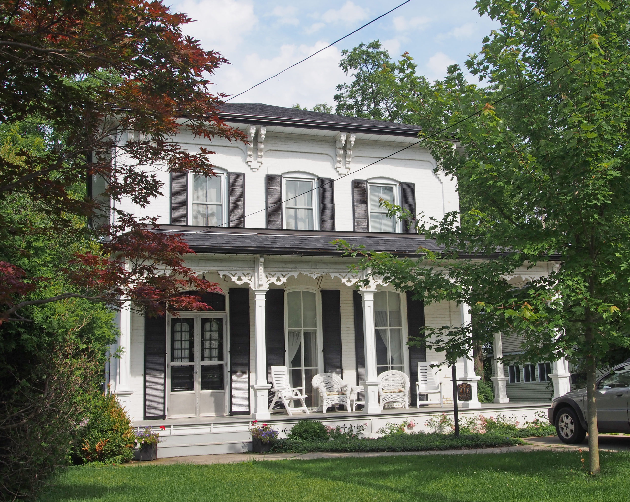
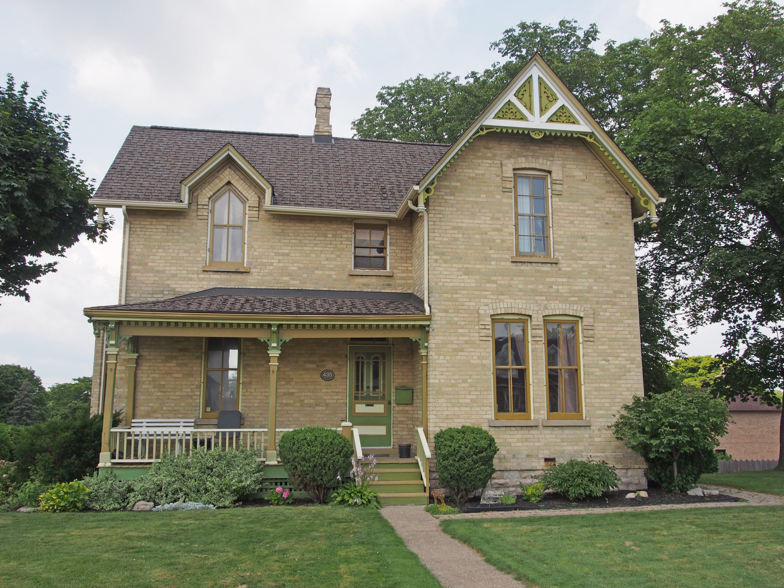
416 Warren Avenue – Italianate, hipped roof, cornice brackets, bric-a-brac on verandah429 Ella Street – Lancey Hall built by Henry Warren Lancey – c. 1876 – Gothic Revival – verge board trim and finials on gables, iron cresting above bay window and enclosed front porchQueen Street – heritage building – Second Empire style, mansard roof, window hoods, iron cresting, cornice brackets, pillared entrance, bay windows4142 Queen Street – manse for St. Philip’s Church – Italianate, hipped roof, dormers, pillared entrance with Ionic capitals, dentil molding, sidelights and transom window
Sarnia is a city in Southwestern Ontario located on the eastern bank of the junction between the Upper and Lower Great Lakes where Lake Huron flows into the St. Clair River, which forms the Canada-United States border, directly across from Port Huron, Michigan. It is the largest city on Lake Huron. The city’s natural harbor first attracted the French explorer LaSalle, who named the site “The Rapids” when he had horses and men pull his forty-five-ton barque “Le Griffon” up the almost four-knot current of the St. Clair River in August 1679. This was the first time anything other than a canoe or other oar-powered vessel had sailed into Lake Huron.
Captain Richard Emeric Vidal (1784-1854), one of the founders of Sarnia nurtured the little settlement for twenty years from his first visit in 1834. His wife, Charlotte Penrose Mitton (1790-1873) lived her last forty years in Sarnia and three streets bear her name (Charlotte, Penrose, and Mitton Streets).
Paul Blundy was born in Sarnia in 1918. He served in the Royal Canadian Navy in World War II. Following the war, he co-founded the McKenzie & Blundy Funeral Home. Paul served four years as a member of the Hydro-electric Commission, twenty years as a member of Sarnia City Council, eight of them as mayor. During his time on City Council, he was a strong advocate for the redevelopment of the waterfront. From 1977 to 1981, he served as M.P.P. for Sarnia. He died in 1992.
191 Brock Street South – Gothic Revival – 1890435 Christina Street North – 1890 – Gothic Revival – barge board trim on gable with stenciling, arched and rectangular windows with voussoirs254 George Street – McCormack Funeral Home, Stewart Chapel – 1880 – Italianate – three bay two story yellow brick building with a central frontispiece topped by a gable with projecting eaves; gable has a blinded round window; brick voussoirs over windows with carved oak leaf keystone; semi-elliptical brick arch doorway with a shared transom197 London Road, Mulberry House 1867 – Gothic/Georgian style – 1½ story yellow brick home, stone foundation; centered on the facade is a frontispiece with a gable roof – Sarnia Book 3223 London Road – 1880 – Italianate – three bay, two story yellow brick house with a centered frontispiece topped by a gable with a semi-circular arch decorated with barge board424 London Road – 1911 – gambrel roofed gables, sidelights and transom312 London Road – 1922 – Georgian – dormers, transom window144 Maria Street – Tudor style – Elizabethan Manor329 Vidal Street North – vernacular, cornice return on gable, wide cornice overhang, fish scale patterning, dentil molding – Sarnia Book 4280 Vidal Street North – 1872 – Gothic Revival, verge board trim on gables, voussoirs with keystones262 Vidal Street North – 1880 – French Canadian home – red and yellow brick detailing, gabled parapets, French bay window251 Vidal Street North – late 1870s – Christian Science Church – bell-cast mansard roof – Second Empire style, vousoirs and keystones, cornice brackets127 Christina Street South – Lawrence Family mansion – Mr. Lawrence was a lumberman – Queen Anne style – 1892303 Brock Street North – Victorian home – 1895 – Sarnia Book 1283 Brock Street North – 1900 – Queen Anne – turret, curved verandah279 Vidal Street North – Edwardian – 1900 – two-story tower with cone-shaped cap240 Vidal Street North – 1900 – Victorian – 3-storey tower with conical roof covered with cedar shingles, fish scale patterning in gable183 Vidal Street South – Queen Anne – three-story turret with cone shaped roof1031 Ellwood Avenue – 1890 – Edwardian – Sarnia Book 2270 Brock Street North – 1890 – Georgian
St. Marys is a town in southwestern Ontario located southwest of Stratford. The north branch of the Thames River flows through St. Marys and is the heart of the town. St. Marys’ early economic success depended on the mills, powered by the water in this river. The town’s prosperity was also helped by the presence of accessible limestone, taken in blocks from the riverbed and from quarries along the riverbanks. The name “Stonetown” is an apt moniker for St. Marys, as the town is filled with unique architecture featuring locally-quarried limestone. The stone buildings reveal much about the town’s history, and the development of the town can be witnessed in the architecture.
John Grieve Lind (1867-1947) was closely associated with the start of the St. Mary’s Cement Company. St. Marys was chosen as the location for the plant because of its abundance of limestone, clay and water, it was on two national railway lines, and it had access to hydro-electric power from Niagara Falls. The plant opened in 1912.
Once the cement plant was in operation, Lind turned his attention to parks and recreation. He purchased the seven acre Cadzow Park on Church Street South and build Cadzow Pool. Lind Park has a statue of Arthur Meighen, Canada’s ninth prime minister.
163 Church Street South – Queen Anne style, turret, dentil molding, dichromatic tile work, wraparound verandah
236 Jones Street East – Ercildoune was originally built as a wedding gift to George Carter’s daughter Charlotte when she married Henry Lincoln Rice in 1880. The home is built in the Second Empire style, a very rare style of home in St. Marys.
67 Peel Street South – built in 1883 for James Carter (wife Mary Box), only son of George Carter, a successful grain merchant in St. Marys – steep gable roofs, tall windows and chimneys with decorative brickwork – Queen Anne style – St Marys Book 2
175 Queen Street East – St. Mary’s Town Hall – This Romanesque Revival building was built in 1901 of local limestone with red sandstone as the contrasting elements for window arches and checkerboard effects in the façade. The massive entrances on the south and west façades of the building and the two towers on the south add to its lasting beauty. Due to its prominent location on the north side of the main street, and dominating as it does the sky-line of the Town, it plays an important role in the character of the downtown area.
96 Robinson Street – built around 1875 for Leon Clench and his wife Eunice Cruttenden. It is now the Riverside Bed and Breakfast. Clench was a lawyer, a builder, inventor, violin-maker, musician and furniture-maker. Italianate style – St Marys Book 3
146 Wellington Street North – Gothic Revival, verge board trim on gable, bric-a-brac and stenciling on porch
145 Church Street North – Gothic Revival, verge board trim and finial on gable, corner quoins, wood turned porch supports, sidelights and transom window surrounding door – St Marys Book 1112 Church Street North – pediment with decorated tympanum, wraparound veranda15 Church Street North – 1905 – Beaux Arts style, Public Library built of St. Marys limestone – pediment with dentil molding, pillars with Corinthian capitals217 Jones Street East – Italianate style – 1875 – verge board trim on gable, cornice brackets, pediment with decorated tympanum, pillars with Doric capitals supporting verandah, bay window with iron cresting above, corner quoins, curved window voussoirs with keystones226 Water Street South – corner quoins, bay window with iron cresting above, pediment17 Water Street South – The Post Office and Customs House built in 1908 – Romanesque style92 Wellington Street North – Italianate – paired cornice brackets, 2½ story tower-like bay with verge board trim on gable, iron cresting above entrance porch – St Marys Book 4127 Wellington Street South – spindled and stenciled bric-a-brac on wraparound verandah; Palladian type window with window hood and stained glass window
Oxford County is located in the heart of Southwestern Ontario and is made up of eight lower tier Municipalities. Zorra Township is located at the north-west corner of Oxford County. It is a rural municipality, and was formed in 1975 through the amalgamation of East Nissouri, West Zorra and North Oxford townships. The township includes the communities of Banner, Bennington, Brooksdale, Brown’s Corners, Cody’s Corners, Dicksons Corners, Dunn’s Corner, Embro, Golspie, Granthurst, Harrington, Harrington West, Holiday, Kintore, Lakeside, Maplewood, McConkey, Medina, Rayside, Thamesford, Uniondale, Youngsville, and Zorra Station.
Kintore, Medina, Thamesford and Uniondale are included in this book of photos.
Thamesford is located on the western boundary of Oxford County, half way between London and Woodstock on Highway 2 (County Road 68) and between St. Mary’s and Ingersoll on Highway 19.
Thames Centre is a municipality in Middlesex County east of the City of London. It was formed on January 1, 2001, when the townships of West Nissouri and North Dorchester were amalgamated. Communities in the township include: Avon, Belton, Cherry Grove, Crampton, Cobble Hill, Derwent, Devizes, Dorchester, Evelyn, Fanshawe Lake, Friendly Corners, Gladstone, Harrietsville, Kelly Station, Mossley, Nilestown, Oliver, Putnam, Salmonville, Silvermoon, Thorndale, Three Bridges, and Wellburn. Putnam is included in this book of photos.
128 Delatre Street West – St. Andrew’s Manse 1897 – “sleeping porch†on second floor, turned wood spindle supports, fretwork, pediment with decorated tympanum118 Delatre Street West – decorative gable and pediment, Romanesque style window voussoirsGeorge Street – Gothic Revival – within peak of gable is a decorative arch with applied scroll work, spindles and circular piercingWashington Street – Edwardian, decorative gable144 Washington Street – Regency cottage155 Allen Street – Neo-Colonial style, gambrel roof205 Allen Street – Gothic Revival – stone architecture, corner quoins, verge board trim on gablesGothic Revival, verge board trim on gable with finial